
‘You’re worried about a grasshopper jumping across a highway’: Internal documents show scientists reject Doug Ford’s environmental study of the 413 Highway
Late marine biologist and writer Rachel Carson, widely considered responsible for sparking the environmental movement, insisted human beings were not in control of nature but simply one of its parts. The survival of one part depended upon the health of all.
Why do we, then, forget this simple fact of planetary survival?
Anthropocentrism.
That’s what psychologists call the human-nature driven disconnection that stems from a deep-seated ego drive to view ourselves as special or superior to others in the biota.
Over the years, nature has been substituted by social excitements, indoor distractions and screens—even the traditional Canadian cottage getaway often places the outdoors in the backdrop now, as people leave the city only to recreate similar social networks up north—fostering what researchers describe as environmental amnesia, an extinction of experience.
Within the walls of our professional, personal and entertainment experiences, which provide a sense of constant engagement, we social animals also birthed the illusion that humans are somehow exempt from the ecological limits that govern all life on Earth.
For more and more people, caught up in the constant cycle of keeping themselves entertained and preoccupied, protecting the planetary systems their lifestyles ultimately depend upon, is a far too abstract inconvenience that just gets in the way of what they would rather be doing. And they do not want to be preached to.
This growing disconnect between lifestyle and its cost to nature may help explain part of the reason why Doug Ford’s PC government continues to push for Highway 413, a 52-kilometre “highway to hell” approved by his decision makers inside Queen’s Park, despite the harm it will do to at least 29 federally protected species at risk.
“Let's build the damn highway…We have been working on this environmental assessment since before Moses,” Ford said at a press conference in September 2024.
“There's hundreds of thousands of people stuck in their cars, backed up from here to Timbuktu and you're worried about a grasshopper jumping across a highway.”
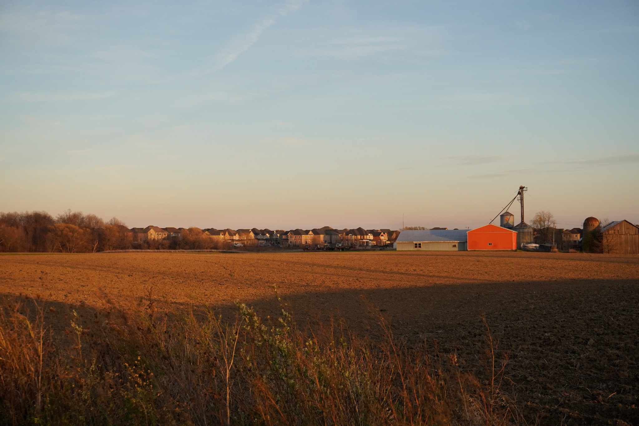
A farm that existed just south of the Highway 413 corridor is gone now, replaced instead by construction of new houses that will be accessed using the future 400-series thoroughfare.
(Alexis Wright/The Pointer)
In April that year, a joint working group was established under the federal-provincial Memorandum of Understanding (MOU) for Highway 413 to avoid and mitigate environmental damage, following the cancellation of the federal environmental assessment that had paused the project in 2021 due to concerns that it would violate legislation such as the Species at Risk Act (SARA), the Fisheries Act and the Migratory Birds Act.
The process remains opaque and federal officials involved in the working group have expressed frustration with the province “not effectively engaging” or simply providing minimal updates, leaving them reliant on media reports.
As of June 19, four Regional Species at Risk Specialist positions and one Fish and Wildlife Technical Specialist role remain vacant within the province’s Species at Risk Branch, according to Ontario’s Employee and Organization Directory.
New internal documents, shared with The Pointer by Environmental Defence, between the provincial and federal working group reaffirm those concerns including the Ministry of Transportation’s (MTO) efforts to fast-track the process and bypass standard environmental assessment timelines for a highway they expect won’t be built in the next 15 years.
Under the MOU, the MTO was required to assess the effects of the 400-series highway corridor on species habitats, particularly the Redside Dace, an endangered minnow known for its bold red stripe, if it was to obtain the necessary permits from the Department of Fisheries and Oceans (DFO).
Section 73 of the SARA relies on a jeopardy assessment, a science-based evaluation that determines whether a proposed activity will “jeopardize the survival or recovery” of a listed species by linking project-related habitat changes to impacts on vital rates such as survival and reproduction and ultimately to population growth to assess whether the overall population outcome remains within allowable limits of harm.
A March memo by MTO staff confirmed a “Jeopardy Assessment has not yet been completed, nor has a permit been issued for works impacting fish and fish habitat or Redside Dace that have Critical Habitat within the Contract limits”.
MTO indicated they are unable to do an overall jeopardy assessment until they reach detailed design, expected to take at least two years to reach. But DFO experts “pushed back” against MTO, advocating there is “likely enough information available” to complete a comprehensive jeopardy assessment and that not all data gaps can be resolved through detailed design work alone.
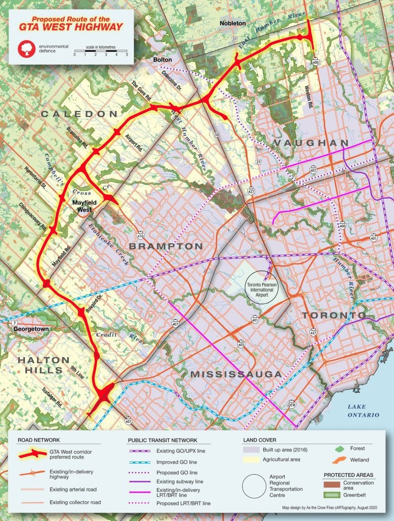
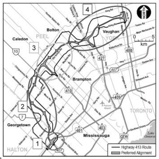
The province has divided Highway 413 design and construction into four sections: Section 1 runs from the Highway 407/401 interchange to Winston Churchill Boulevard including Trafalgar Road to Winston Churchill Boulevard. Section 2 spans western Brampton into southern Caledon from Winston Churchill Boulevard to Chinguacousy Road. Section 3 covers south and central Caledon, extending from Chinguacousy Road to The Gore Road and including the Highway 410 extension. Section 4 moves through eastern Caledon into Vaughan, from The Gore Road to Highway 400 and includes the Highway 427 extension.
(Government of Ontario/Environmental Defence)
Instead, the ministry proposed to subdivide the jeopardy assessment into four discrete assessments that align with the proposed construction segments.
The “relatively long length of highway” prompted the province to explore ways to phase both detailed design and construction to provide flexibility in managing financial, design, resource and construction demands while also responding to municipal requests to align highway construction with local infrastructure initiatives including Brampton’s Heritage Heights.
Because full detailed design information is not expected to be finalized until 2039, MTO argued that waiting for a single comprehensive jeopardy assessment for the entire corridor would delay permitting and “severely limit” completion of large portions of the project before the 2041 horizon year.
The ministry contended that the approach aligns with how the province has delivered its other major infrastructure projects including the Bradford Bypass, Highway 407 East Extension, Highway 11/17 four-laning and Highway 7 widening.
If given the go-ahead, the first assessment will be done for Section 3 to “support the Highway 410 extension” that covers south and central Caledon, extending from Chinguacousy Road to The Gore Road.
“The MTO is arguing it makes sense from a procurement perspective. But do you allow the procurement to drive your environmental assessment?,” Environmental Defence Associate Director, Mike Marcolongo, told The Pointer.
“Because it certainly doesn't make any sense from an ecological perspective.”
The federal working group warned that splitting the assessment could lead to incomplete coverage of species populations within individual sections, making it significantly more difficult to account for cumulative effects under a four-part approach and “understanding the project as a whole”.
“The four construction units appear not to be aligned with Redside Dace populations,” a scientist on the committee noted in an email.
“Splitting has the added challenge or providing an incomplete picture of how each highway section would lead to the overarching landcover changes that are anticipated to impact Redside Dace.”
DFO asked the province for an overall plan explaining how the jeopardy assessment will be carried out and how existing and future data will be used while also questioning how the proposed population modelling would define and apply thresholds beyond which a species cannot persist.
Scientists had already raised concerns about MTO relying on “old”, outdated information from 2012, “limited to that of the Humber River watershed” on redside dace populations within the Highway 413 corridor despite “all publications” pointing to “continued decline in the population”.
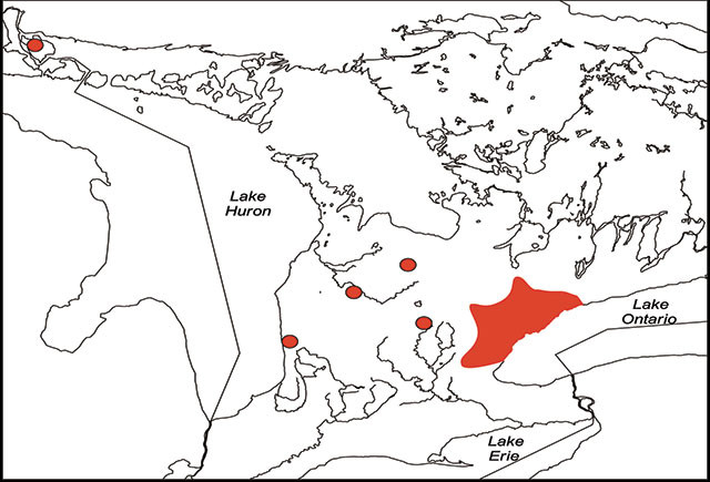
In Canada, Redside Dace are only found in southern Ontario and the Two Tree River on St. Joseph Island.
Listed as endangered in Ontario since 2009, the redside dace has been steadily disappearing from streams under pressure from habitat loss and declining water quality linked to urban expansion and agricultural runoff.
But why is this tiny, beautiful fish so important and why should Ontarians care?
The redside dace is the only known minnow that can leap out of the water to catch flying insects. In doing so, it plays a small but vital ecological role: linking land and water ecosystems by feeding on terrestrial insects like flies and mosquitoes, helping naturally manage localized pest populations and transferring that energy into the aquatic food web.
As part of the food chain across watersheds, this unique fish also acts as prey for larger fish and birds.
Its survival functions as a living indicator of stream health, as it cannot survive in warm, polluted or heavily disturbed waters, making its presence a signal of intact, high-quality habitat and its disappearance an early warning of the ecosystem’s decline long before other species are affected.
Once its population declines, its recovery is rare due to its highly specific spawning and habitat requirements. A 2016 provincial report noted redside dace typically matures at around two years but may not spawn until its third; even then, reproduction is limited to a narrow late-spring window when water temperatures reach 16 to 18 degrees Celsius. Although females can produce 400 to over 1,500 eggs, only a small number survive to adulthood.
Today, nearly 90 percent of its remaining Canadian population is concentrated in the Greater Toronto Area, where the species depends on cool, clear, slow-moving headwater streams.
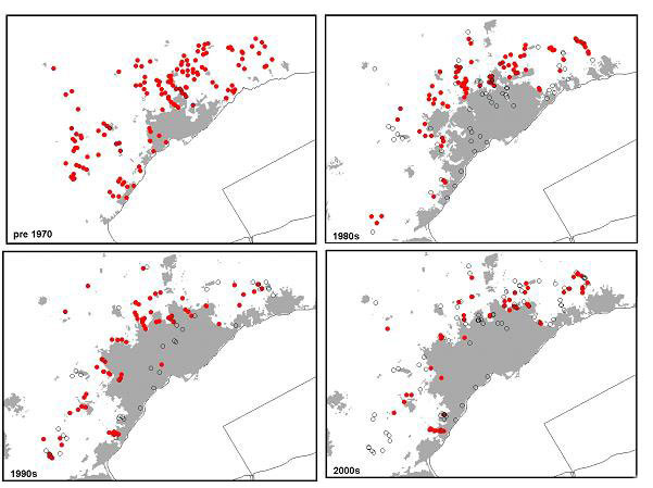
Historically, the redside dace was found in 24 watersheds across the province but its status has steadily worsened over time: from provincially vulnerable and a national “special concern” in 1987 to “threatened” in 2000 when it remained in about 20 locations and finally to “endangered” in 2009 as it declined to just 16 watersheds.
(Government of Ontario)
“If we're going to prevent the extinction of the redside dace in Ontario, you can't develop the highway through its existing rooting the way you intend to,” Marcolongo critiqued.
The province’s recent legislation has dramatically altered environmental governance, removing the remaining species protection in Ontario: with watershed protection potentially weakened through the consolidation of the 36 Conservation Authorities into nine regional bodies, overseen by the Ontario Provincial Conservation Agency (OPCA). Similarly, critics have noted protections for species-at-risk habitat have been significantly weakened under the Species Conservation Act introduced through Bill 5, a bearer of environmental “slaughterfest” — shifting much of the responsibility for protecting at-risk species onto the federal government. Currently, no member of COSEWIC participates in the Highway 413 working group since the body “does not have a role in project impact assessments or in addressing project risks”, an ECCC statement shared with The Pointer noted. “Regardless of whether a federal Impact Assessment is conducted, Ontario remains the decision maker for the project’s final design and must comply with all applicable federal legislation including the Fisheries Act, the Migratory Birds Convention Act and the Species at Risk Act.”
Renowned redside dace researcher and University of Toronto Conservation Biology Professor, Nicholas Mandrak, who is part of the working group, told the province that “there are no known approaches to mitigate Highway 413’s effects” — the federal government’s Fish and Fish Habitat Protection Program “confirmed agreement” with his “expert opinion”.
Marcolongo stressed that a jeopardy assessment would at least help understand both the “direct and indirect impacts” of constructing the corridor since building Highway 413 through the headwaters of the Humber, Credit and Etobicoke watersheds would not only disturb species habitat directly but could also introduce a cascade of secondary impacts from sediment and runoff during construction to road salt and contaminants washing into streams for decades after the highway opens.
“A highway doesn't stop affecting the environment at the edge of the asphalt,” he remarked.
“I'm not a scientist but you can't just look at the project itself and the project area itself. Because you're paving over the headwaters of the Humber, the Credit and the Etobicoke; and you're paving over thousands of acres with asphalt and you're introducing tens of thousands of cars per day—it will have significant impact, much further than the actual footprint of the highway.”
He questioned why more attention has not been given to redesigning or rerouting portions of the project to steer clear of critical Redside Dace habitat: “Instead of saying no to the highway, the question should be: can this highway be built while avoiding critical habitat, and what would the real cost of doing that be? That conversation hasn't happened.”
On June 2, Environmental Defence, Open the 407 Now, and representatives from the Ontario NDP, Ontario Liberals and Ontario Greens held a joint press conference at Queen's Park calling on Ontario's Financial Accountability Office (FAO) to conduct an independent review of the project's costs. Critics estimate the 52-kilometre highway could ultimately cost taxpayers between $16 billion and $18 billion, making it one of the “costliest” transportation projects in Ontario's history.
While the coalition is still waiting to hear back from the FAO, Marcolongo said the province has never adequately explored alternatives to the mega-highway. Regional road improvements, expanded public transit and greater use of Highway 407 have all been raised as options that could address transportation needs while avoiding some of the ecological risks posed by Highway 413.
He warned that advancing construction on some sections before securing permits for the entire corridor could expose taxpayers to financial risk if approvals for later segments are delayed or denied.
But the move might extend beyond “playing chicken with taxpayer money”.
He questioned whether the Progressive Conservative (PC) government’s decision to break the project into four permitting segments could create pressure on federal regulators later in the process.
The Ford government has already been making misleading claims about starting construction on Highway 413 when in reality it has been the start of “early works” that don’t require federal approval.
“While MTO is proceeding with some early project activities, no work that would affect Redside Dace critical habitat is expected to occur until DFO has completed its review of any MTO applications for a permit,” DFO Regional Director, Communications, Jordan E Charbonneau, told The Pointer.
However, the Province’s push is now flooding into Peel’s official documents. The Town of Caledon has accepted its fate under Mayor Annette Groves, who has switched her stance on Highway 413 since being opposed to it during her election campaign: At a June 16 Caledon Planning and Development Committee meeting, officials advanced an Official Plan Amendment to implement provincial designations for Highway 413 and the Northwest GTA Transmission Corridor — it included notable change in language from a “planned” highway to a “proposed” “Highway 413 Controlled Access Highway Corridor.
If the government wanted to build “trust and demonstrate that it is pursuing the least harmful option”, Marcolongo believes the Ford government would start with one of the most challenging portions of the corridor: Section 4 (from eastern Caledon to Vaughan) that intersects habitat for Redside Dace, Rapids Clubtail and Western Chorus Frog, and demonstrate how it plans to avoid or minimize impacts to critical habitat in the area.
“MTO’s showing their cards quite early in the process that their intentions aren't to follow the science to try and address the fact that unfortunately, there's a number of species that will be extirpated,” he noted.
“The approach is: let us move forward on the rest of the project and we'll chat with you later about the even more difficult permitting section.”
Email: [email protected]
At a time when vital public information is needed by everyone, The Pointer has taken down our paywall on all stories to ensure every resident of Brampton, Mississauga and Niagara has access to the facts. For those who are able, we encourage you to consider a subscription. This will help us report on important public interest issues the community needs to know about now more than ever. You can register for a 30-day free trial HERE. Thereafter, The Pointer will charge $10 a month and you can cancel any time right on the website. Thank you
Submit a correction about this story
