
Peel’s 11K-acre boundary expansion pushed by developers & the PCs, has not been reversed
Two years ago, hundreds of Peel residents descended on regional council to voice their opposition to a massive urban boundary expansion that would pave the way for 11,000 acres of prime agricultural land and greenspace to be bulldozed for future development.
This summer, those same residents, along with millions across the province, learned the startling truth behind what happened. Doug Ford’s PC government had worked secretly with developers to force urban boundary expansions throughout southern Ontario, compelling towns and cities to bend to their profit-driven policies.
Peel councillors on the planning committee who heard, loud and clear, how their residents felt showed no signs of being swayed by the delegates, but it was emphatically stated that even they did not like the plan in its current form, and that the 11,000 acres was only being approved because the provincial government had given elected officials no choice. In a cover letter attached to the approved official plan, councillors wrote they would like to share “our concerns with the rigid Provincially mandated policy framework.”
That was before two investigations laid the entire scheme bare.
Ontario’s Auditor General and Integrity Commissioner provided a step-by-step account of how the PCs worked behind the scene with powerful developers to force land use policies, which made little sense, onto municipalities.
The housing minister, Steve Clark, resigned. Business service minister, Kaleed Rasheed, resigned. Clark’s chief of staff resigned. The RCMP was called in, and launched a criminal investigation which is ongoing.
Then, last week, Bill 150, which gives municipalities the chance to change certain land-use policies forced by the PC government in 2022, received Royal Assent. For the Region of Peel the controversial Official Plan passed by council in April 2022, which included the substantial boundary expansion into 11,000 acres of farmland largely in south Caledon, could still stand, if councillors continue to ignore calls from their constituents to turn around all decisions made under the influence of powerful developer interests.
Following the adoption of the Region of Peel Official Plan, in November 2022, the Ministry of Municipal Affairs and Housing (MMAH) forced 44 amendments onto the blueprint for future growth in the area. Some were minor adjustments to protected areas, while others modified land-use designations following developer requests. The modifications did not align with comments on the Environmental Registry of Ontario (ERO) posted by the public, which urged the government to use existing urban boundary lands to create more density for future growth, instead of sprawling out across rural areas that should be protected.
The Ford government has been forced to reverse its developer-driven policies after the blistering reports from Ontario’s Auditor General and Integrity Commissioner. Constant questioning by opposition parties, and Freedom of Information requests, have helped show how the PCs allowed the development industry to dictate its planning decisions.
As part of his “priority to review past decisions”, on October 23, new Housing Minister Paul Calandra announced he would introduce legislation to walk back some of the Ministry changes to Official Plans in 12 municipalities.
“The process was one that I was just not comfortable with. I think there was a little bit too much involvement from individuals within the previous minister’s office on the official plans in these areas,” Calandra admitted, weeks after replacing the disgraced former minister. He stated the review of past decisions was necessary “to ensure that they support our goal of building at least 1.5 million homes in a manner that maintains and reinforces public trust.”
“In reviewing how decisions were made regarding official plans, it is now clear that they failed to meet this test,” he acknowledged.
Under Bill 150, dubbed the Planning Statute Law Amendment Act and introduced on November 16, municipalities were given until December 7 to make submissions regarding projects underway or changes to Official Plans. The posting on the ERO would be open until December 16.
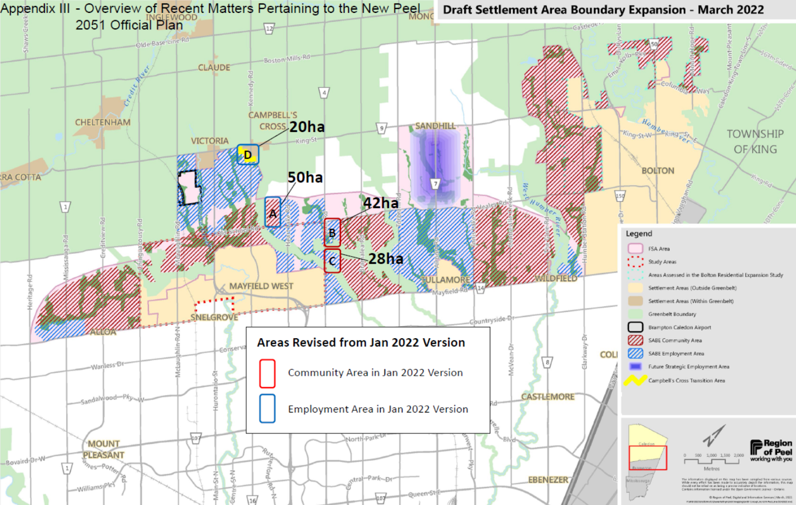
Land within the expanded urban boundary is designated as employment or community (residential) under the Official Plan.
(Region of Peel)
On November 28, Caledon councillors voted on a motion requesting the MMAH keep the vast majority of the modifications it implemented under former minister Clark, in the Peel Official Plan. Staff told council many of the modifications made by the Ministry were more closely aligned with Caledon’s own growth strategy.
Dissatisfied with some of the zoning designations in the Regional Official Plan, Caledon subsequently submitted a “made in Caledon” Growth Concept which would allow the Town to be in control of many of the planning amendments within its own borders.
“Caledon is welcoming and preparing for an unprecedented amount of growth in our community and it is important to do so responsibly, strategically and while delivering strong customer service to our industry partners,” officials communicated on the Town’s website regarding the Growth Concept. “This approach to planning will improve the quality of life for Caledon residents while welcoming growth by creating smart growth processes, unique to Caledon, that benefits everyone.”
But the modifications made under Clark also included more questionable zoning changes that have been overlooked by some Caledon council members and staff.
Ward 3 Councillor Doug Maskell had particular concern with modification number 40 which changes the designation of the lands between Old School Road and Mayfield Road, on the west side of Torbram Road from Rural Community Area to Employment Area. Documents received by environmental advocacy group Environmental Defence through an FOI request suggest these lands, owned by the Rice Group, were not originally being considered by staff for modification under the Official Plan until a letter was received by the Minister’s Office from representatives of the Rice Group requesting the lands be considered under the employment area designation.
“In my opinion, the changes would result in the PROP being more consistent with the Provincial Policy Statement (2020), more in conformity with the Growth Plan for the Greater Golden Horseshoe (2020), and represent the best planning in the public interest,” the letter, dated September 9, 2022 stated.
This designation was then included in the modified Official Plan.
Maskell was the only councillor opposed to the motion to allow the Minister’s modifications, which are in line with what the developer, Rice Group, lobbied for. Regional Councillor Christina Early abstained from voting due to a pecuniary interest.
Bill 150 makes Caledon’s position, in support of the developer, difficult to uphold, and Maskell said he thinks “this is good news for Caledon” which will be forced to conform with a Peel Official Plan more aligned with smart growth principles.
The week following Caledon’s discussion, both the City of Mississauga and the Region of Peel councils had similar reports on their agendas requesting the Province revert back to the previously approved regional Official Plan. Both councils passed motions to revert back to the Peel Official Plan. While Maskell does not have a seat at the regional table, he previously expressed concern to The Pointer that his fellow Caledon councillors did not fully understand the land-use implications they supported earlier at Town council when they voted to keep the Minister’s amendments, then later voted the opposite way at regional council.
Regional Councillor Mario Russo explained to The Pointer in an email statement that his motion at the Town level was carefully crafted with the help of staff to be very thorough regarding the Town’s desire to closely follow the Caledon Growth Concept.
Regardless, the final decision by the Ministry under the new provincial legislation is largely aligned with the decisions made by Regional Council, removing all developer requests from the Official Plan.
Of the 44 original modifications rammed through under Clark, nine survived Bill 150, and these items primarily deal with technical planning changes.
While the provincial legislation restores much of the planning authority of municipalities that was removed by Clark, the move does nothing to change the 11,000-acre urban boundary expansion that angered local advocates, farmers and environmental groups.
Caledon Mayor Annette Groves has long been a progressive voice at the Region of Peel, yet even she has made no move to reverse the 11,000-acre expansion.
(The Pointer files)
Of the 24 elected members on Peel Council, Caledon Mayor Annette Groves, who was a regional councillor at the time, was the only one to vote against the urban boundary expansion in April of 2022. Despite dozens of delegations and a flood of letters from residents and organizations on the agenda for the day, all fiercely opposed to the expansion, every member other than Groves ignored their concerns.
Mississauga and Regional Councillor Carolyn Parrish, who was at the time chair of the Regional Planning and Growth Committee, expressed concern that if council did not vote for the expansion, the PCs would force it on them (or something even worse) as was later seen in Halton Region and Hamilton.
“Had the the committee not accepted the staff recommended expansions, the province would have done it with a broad brush and no guidance as to easily serviced areas already adjacent to developed communities and away from areas that would have had severe impacts on environmentally sensitive areas,” Parrish told The Pointer following the province’s announcement to walk back legislation. “And as we saw with other municipalities, had the committee, staff and council not made our own carefully thought out decisions, the province would have done it for us based on their own criteria.”
Bill 150 allows affected municipalities to choose between their own official plan or the Ministry’s modifications; there was no third option for additional changes. Because of the timing of the vote back in April of 2022, Peel municipalities are stuck choosing between an 11,000-acre boundary expansion, or an additional 600-acre expansion on top of that, with 44 other provincial modifications.
Peel could reverse the boundary expansion through a new official plan but existing applications from developers to build in the expanded 11,000 acres would likely be grandfathered in. Staff predict the region will grow by an estimated 700,000 residents by 2051, bringing the total population to approximately 2.28 million. Using these projections, regional staff completed a land needs assessment (LNA) in 2021, determining that a balanced approach to future growth, with a mix of densities, would require an additional 10,873 acres mostly for residential expansion and some for employment lands.
According to the staff report on the agenda for the April 2022 meeting, the settlement area boundary expansion was created in consultation with municipal planners, stakeholders and the public. However, over 300 written comments were received by the Region in objection to the expansion, none of which were given any consideration.
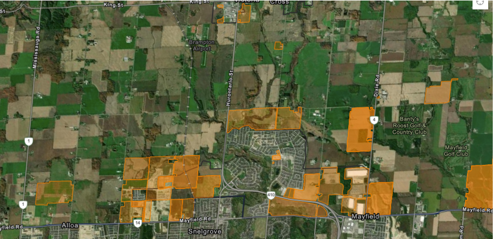
Current development applications (outlined in orange) will take out large chunks of farmland and greenspace.
(Town of Caledon)
Registered professional planner Kevin Eby produced a report for the advocacy group Alliance for a Liveable Ontario detailing land available within existing boundaries for development, offering a solution of medium density housing. His report, which has been widely accepted in the planning community across Ontario, concludes there is a minimum capacity for an additional 223,000 units within the previous Peel settlement boundary (which does not include the expanded 11,000 acres) enough to accommodate the 246,000 housing units mandated under Bill 23, if more dense urban planning is used. This type of housing, in more of a compact community design created with transit access in mind, is easily serviceable and accessible, and much more affordable for each of Peel’s municipalities.
Eby said that without studying the specific case scenario, including staff projections all the way out to 2051 and accommodations for larger family housing to meet “market” demand, he cannot comment on whether Peel would need the additional 11,000 over the next three decades.
The PC housing plan under Bill 23 only goes to 2031, the deadline for when the provincial government wants 246,000 units built across Peel.
Eby says his modelling covers needs to “2031” and Peel should not be planning as though the 11,000 acres is needed for growth over the next eight years, “because it's not, there's clearly more than enough land,” he told The Pointer. “But once you go to 2051, while we would encourage virtually every municipality to try to deal with the forecast within the boundaries, there were some that that transition would be very difficult.”
He said it is crucial that municipalities consider maximizing densities in order to minimize the amount of additional land needed. One of the issues he identified with the LNA model that was used by municipalities, is that the province decreased the density target from the 2017 growth plan, giving them the opportunity to sprawl outwards.
Regional staff have claimed that if Peel does not provide buyers with options for larger homes in less compact areas, they will “leapfrog” the region and go elsewhere for more space.
Eby says municipalities and the province cannot plan for the future by looking at the past. The same single-detached homes that were the dream of the baby boomer generation are not necessarily as desirable or affordable for today’s young adults. As older generations downsize toward the end of their lives, single-detached homes will be on the market, negating the need to build new ones.
“We just can't look at what we did before and extrapolate it forward. And the more land we bring in, and prematurely plan, the more difficult it is to course correct in the future, if we find we need significant changes,” Eby said. “If we know anything at all, it's that the future is not the past.”
For Eby, Bill 150 is a “huge step forward” because it takes away all of the land that was arbitrarily added by the province, in total absence of proper consultation.
“Bill 150 rolls that back and at least gets us back to the point where the municipal councils had gone through the proper process. Did they come to the right answers? I think in some cases that's questionable whether they did or not, but at least they did it in consultation with First Nations in consultation with the public. And conceivably, the lands that they've promoted, were properly supported by infrastructure studies that demonstrated they could be serviced,” he said. “So Bill 150 at least gets us back into the realm of possibly being good planning.”
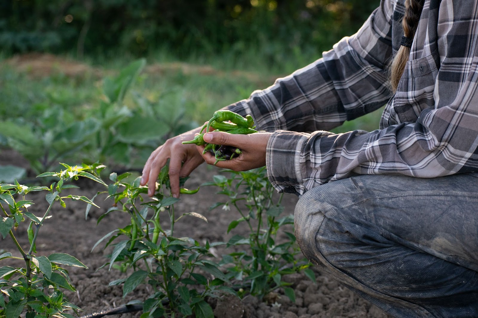
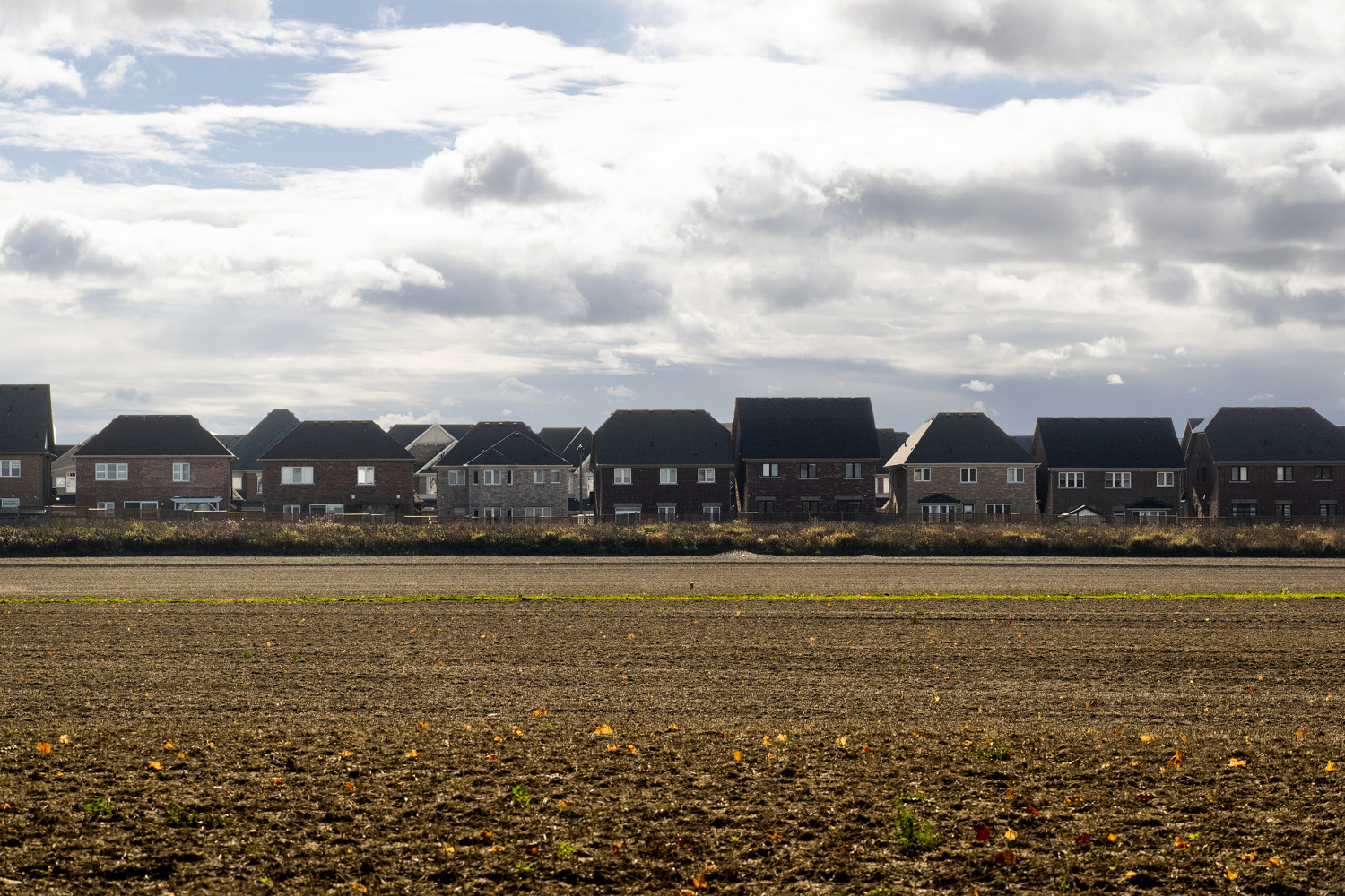
The Region of Peel holds some of Ontario’s most fertile farmland.
(Alexis Wright/The Pointer)
Previous reporting from The Pointer has shown the majority of the Caledon and Brampton land in the expanded urban boundary is vital farmland.
Ontario is already losing 319 acres of farmland a day and, bordering on the Greenbelt, the Region of Peel is blessed with some of the most fertile soil in southern Ontario. An 11,000-acre expansion—about a sixth of Peel—will render this land unusable at a time when food insecurity is rapidly increasing.
The urban boundary expansion pushes into the Greenbelt which serves as habitat to a wide range of species at risk. Given there is no mandate for the government to study the cumulative impacts on these species, even a single development could put them in harm's way. The selection of lands was seemingly made without consideration of natural features. The closer development encroaches to natural waterways, which flow out into the Great Lakes, it increases the risk of contamination to critical freshwater sources.
The late Jenni Le Forestier, a co-founder of Stop Sprawl Peel and leader of the Dufferin-Caledon Greens, previously told The Pointer that, “Even though people call it the white belt, and it's been sitting there, sort of waiting to be developed, it doesn't change the fact that the soil is actually prime farmland soil.”
Email: [email protected]
Twitter: @rachelnadia_
At a time when vital public information is needed by everyone, The Pointer has taken down our paywall on all stories to ensure every resident of Brampton, Mississauga and Niagara has access to the facts. For those who are able, we encourage you to consider a subscription. This will help us report on important public interest issues the community needs to know about now more than ever. You can register for a 30-day free trial HERE. Thereafter, The Pointer will charge $10 a month and you can cancel any time right on the website. Thank you
Submit a correction about this story
