
Peel approves urban expansion into nearly 11,000 acres of farmland and green space
The Region of Peel has voted to approve its Official Plan to 2051, which includes expanding the urban boundary nearly 11,000 acres.
The approved plan expands the Region’s urban boundary—the area within which landowners and home-builders are allowed to submit applications for development—past Mayfield Road in Brampton and around the Village of Bolton in Caledon, adding about 4,400 hectares for future development.
Peel was told by the Province of Ontario to adopt a strategy to accommodate its projected population and employment numbers in 2051. Local planners refer to this as the municipal comprehensive review (MCR), which is mandated under A Place to Grow: Growth Plan for the Greater Golden Horseshoe, the legislation that controls how much of Ontario plans for its future. The project has been undergoing studies, consultations, reviews and modifications since 2013, with a July 1, 2022 deadline.
The land within the expanded urban boundary is now designated as employment or community (residential) areas under the updated Official Plan.
(Region of Peel)
The Ontario government has told municipalities if they do not submit their planning visions on time, the Province has the option to step in and create a plan of its own. It was the threat of a developer-friendly PC government controlling Peel’s planning that councillors used as reasoning for approving a growth approach that critics have said will trigger more sprawl and not the dense, walkable communities the Region claims it wants to see in its future.
In 2020, the Places to Grow Act was amended by the current Progressive Conservative government to reflect the tight deadline of July 1, 2022 and loosened specific density and intensification targets, making it easier for Ontario’s sprawl-creating developers.
Under this legislation Peel is required to create a forecasted plan to 2051—an unprecedented timeframe of 30 years— to accommodate 700,000 people and 335,000 jobs the Province projects will arrive in Peel over that time.
Thursday’s meeting featured emotional pleas from residents, making one last ditch effort to convince councillors that their plan was setting Peel up for disaster, both in terms of planning and its contributions to the climate crisis.
The meeting also saw a last second push by Caledon Mayor Allan Thompson to unlock even more land for development. The motion, which would have extended the urban boundary further into Caledon and around Bolton, was labelled a “sneaky” trick, and eventually referred to staff to look into the need for even more land gobbling development.
Several delegations and hundreds of letters urged council to freeze the urban boundary, or at the very least, wait until after the June 2 provincial election to approve the MCR, as both a PC loss has the potential of a new government cutting planning horizons from the never-before-seen timeframe of 30 years set by the PCs.
Chair of the Regional Planning and Growth Committee (PGC) Carolyn Parrish raised concerns in a letter that is to be attached to the Official Plan when it is sent off to the Province. It details the pressure the municipality felt to plan so far in advance at such a quick pace.
“In adopting the new Official Plan, I wish to record on behalf of Peel Regional Council, our concerns with the rigid Provincially mandated policy framework which has removed the opportunity to stage Official Plan approvals of required new settlement expansions over several decades which has been afforded to Peel in previous long range planning cycles,” the Peel letter reads.
Members of the public urged council to defer the plan until after the election, which would still allow them to conform with the July 1 deadline if the PC government was reelected. The New Democratic Party have promised if elected the deadline Peel is so scared of would be put on pause. The Liberals have yet to confirm any details on the subject.
Twice during Thursday’s Council meeting Adrian Smith, the Region’s Chief Planner, was asked why Peel could not simply wait.
“The risk to not proceed with the adoption, the official plan now is that the province steps in and makes the decision for us,” he said to council. “Not only the decisions around settlement expansion, but also around updating and modernizing the policies in the plan that guide growth and investment, covering all aspects of complete communities and healthy development and climate change, all the priorities and divisions that have come through many years of public consultation.”
Smith also cited Mississauga, Brampton and Caledon staff are awaiting the Region’s final decisions so they too can move forward with the municipalities’ Official Plans.
Council and Smith’s fear are unfounded. The Province will not step in before the July 1 deadline. So even if the PC government is re-elected on June 2, that leaves Peel council weeks to bring forward the plan in its current form and vote on its approval. When asked to comment on this discrepancy, Smith reiterated his previous statement about the risk of the Province’s intervention.
“You're not breaking any rules by doing that,” Phil Pothen, environmental lawyer with Environmental Defence told councillors. “This is key because contrary to what we've heard, the official opposition has now made it crystal clear in black and white, that if they form government, they will remove the policies that have been cited by consultants as the reason why Peel might need to extend the settlement area boundary.”
The Pointer reached out to Councillor Parrish for a statement, who declined to respond, referring any further requests to Smith. Regional Chair Nando Iannicca did not respond to a request for comment.

The Official Plan will result in the destruction of thousands of acres of prime agricultural land in Caledon.
(Natasha O’Neill/ The Pointer)
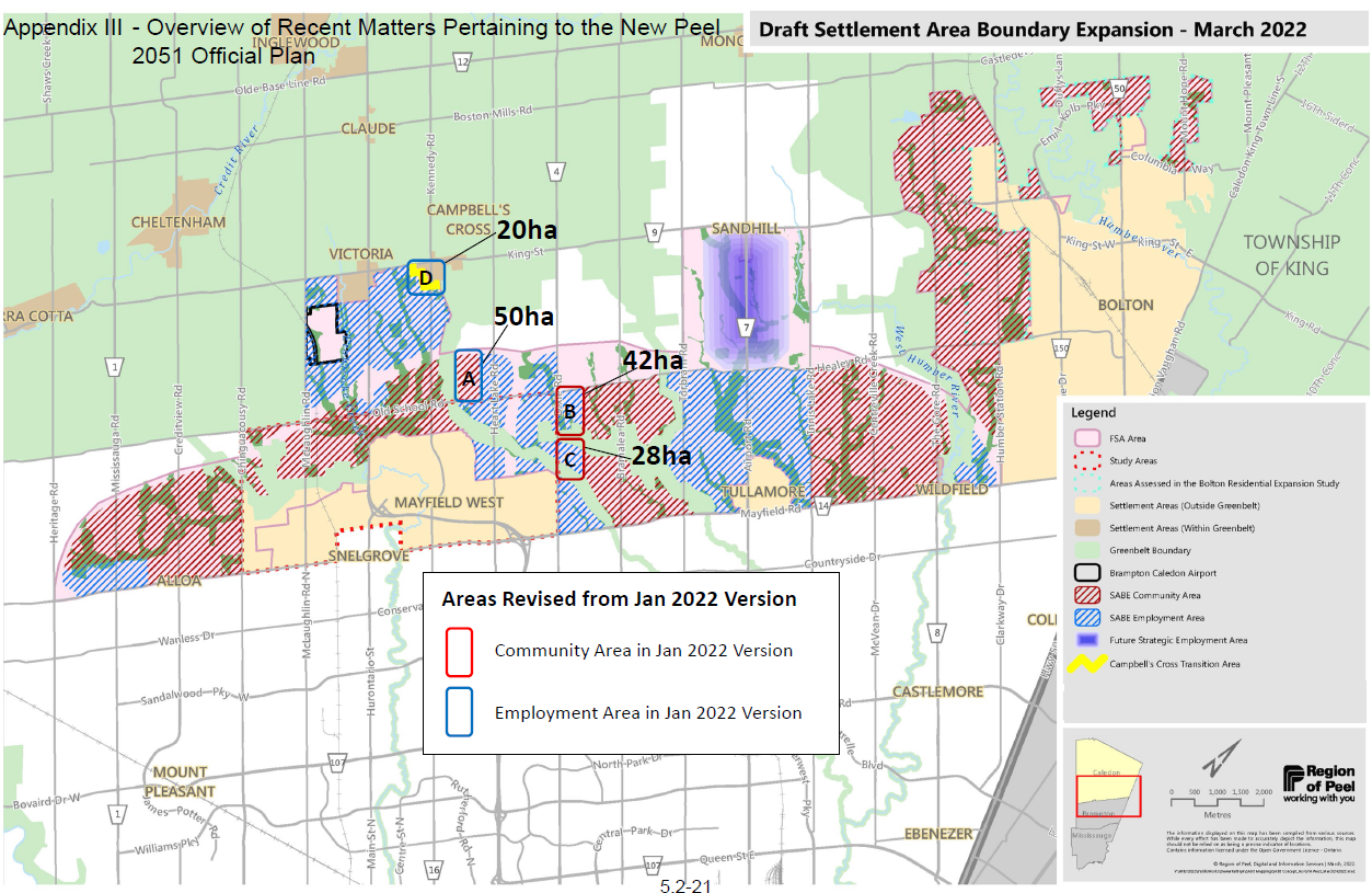
In the past few years, Regional staff conducted a land needs assessment (LNA), a study mandated by the Province, which drew conclusions for a Settlement Area Boundary Expansion (SABE), which led planners to determine Peel would need 4,400 hectares (almost 11,000 acres) of land outside of the urban boundary.
Staff and the PGC members have said this is a “balanced” approach, taking into consideration the need to accommodate future growth, while being cognizant of the environmental damage growth could cause and the impacts on the ongoing climate crisis.
Members of the public throughout meetings and consultations raised concerns, noting that the Region has targets to lower greenhouse gas emissions over the next few decades. Residents have also questioned whether the Region is utilizing all the current greenfield and brownfield land within Peel to its full extent.
These sites total about 14,000 acres of land the Region could use for both employment and residential land.
Under the Growth Plan, municipalities must undertake a LNA, which takes into account five different scenarios with ranges in density and land needed to accommodate the population. The Province set a minimum intensification rate for Peel at 50 percent. Staff’s recommended “balanced approach” has the intensification rate at 55 percent with boundary expansion. Without encroaching further into rural Caledon the intensification rate would be around 75 percent according to previous staff reports. Intensification rate refers to the percentage of new development that takes place within the exiting settlement boundary.
While there is a set minimum, the Province does not dictate a maximum intensification rate, allowing cities to build denser communities, if they choose.
The LNA also asks municipalities to consider the housing market, which ultimately results in the need for cities to sprawl when the focus becomes large single-detached family units. In response to how the LNA is conducted, Regional staff wrote in an October 2021 report, “the market-based approach is primarily determined by considering historic trends in housing.”
Staff determined there was a “historic preference” for single and semi detached homes over apartments and other more dense forms of housing.
In order for staff to comply with provincial legislation and accommodate the housing market, they must use historic data to determine future needs, a backward approach forcing cities to look to the past, not the future.

The housing market, and predictions of future demand for larger houses, played a significant role in staff’s reasoning to expand the urban boundary.
(Region of Peel)
Thursday’s council meeting brought fresh faces to the debate, including some young voices of opposition to the Region’s plan. Anne Biason-Hart, a 21-year-old resident from Caledon East told an endearing story about her rural upbringing.
“In kindergarten, my school backed onto a farm that produced corn. It was called St. Cornelius Elementary School,” she told councillors. “One time a cow wandered onto school property. It was swiftly returned to its owners, but these are the kinds of stories that will cease to exist in a future where Peel is completely paved over and where there are fewer green spaces and farmlands.”
Growing up, Baison-Hart witnessed the town she calls home dramatically change, with subdivisions increasing and prime agriculture being paved over for warehouses and parking lots.
“As councillors, I believe that it's your job to protect our communities, environments and people from things such as pollution and investing in the wrong industry,” she said. “It's a common occurrence for leaders to deflect the blame on others, or on the broad term of climate change when they themselves approved the plans to cause the pollution in the first place.”
When the delegations concluded, council looked over three motions from councillors. All passed successfully.
Caledon Mayor Allan Thompson drafted a motion to rezone a portion of landed owned by the Osprey Valley Golf Course rezoned from Prime Agricultural Area (PAA) to Rural Lands, which opens up significantly more opportunities for development. PAA designation allows only farming related activities on the land.
Located in the northwest corner near the Village of Alton, the rezoning would open approximately 39 hectares for development.
The owners have delegated to the PGC before and Thompson has routinely brought up the land, asking staff to change the plan. According to an April 14 report, the property is “high scoring” in terms of agricultural use.
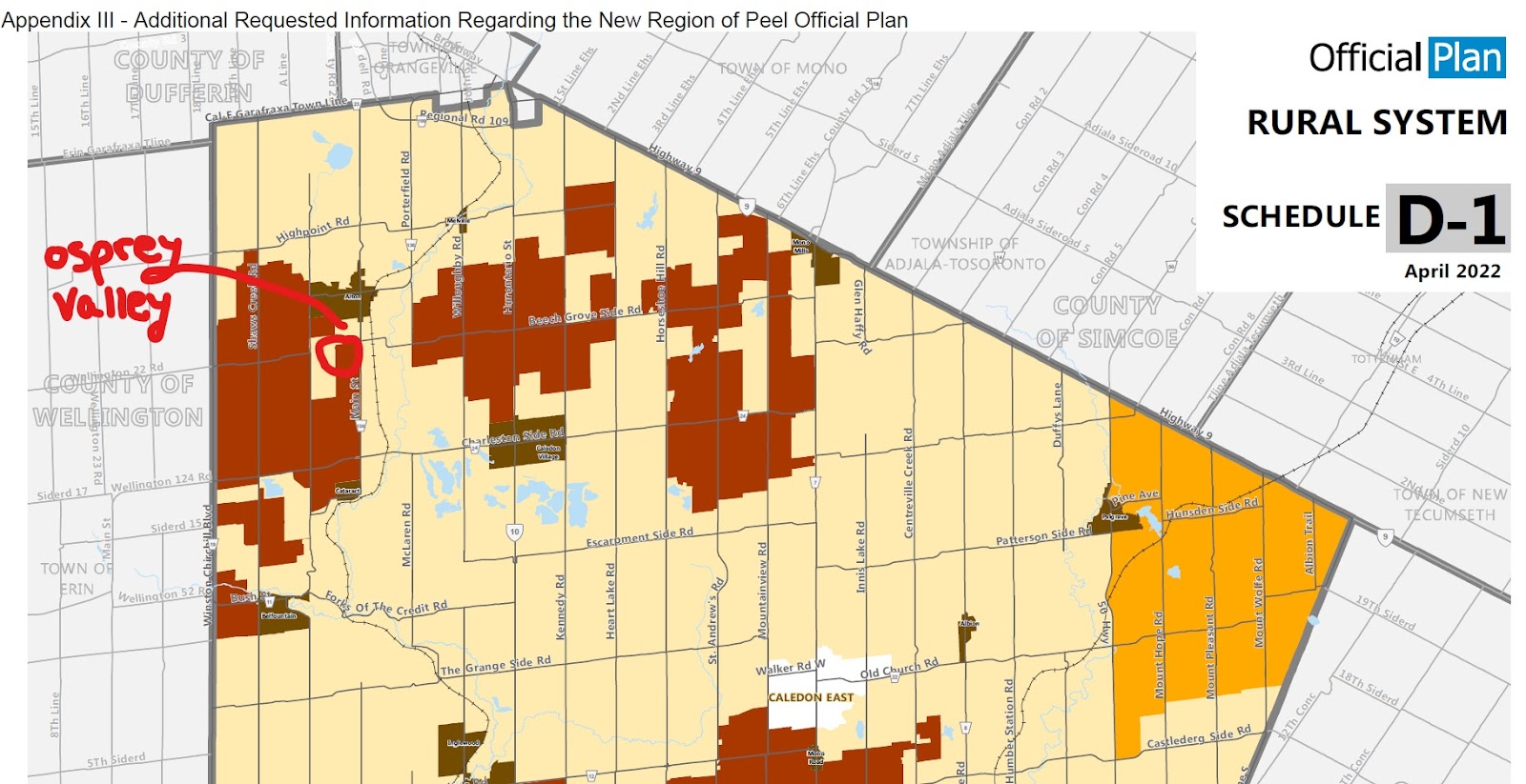
The above image shows Caledon Mayor Allan Thompson’s move to help Osprey Valley continue its development as a major golf destination.
(Region of Peel/ with notes from Natasha O’Neill)
In 2016, the Region along with the Town of Caledon undertook a Land Evaluation & Area Review (LEAR) which identifies prime land and its uses and informs official plans.
“The LE factors apply to physical components such as soil quality and climate while the AR factors apply to socio-economic considerations such as parcel size, fragmentation and conflicting land uses,” the study reads.
Staff initially recommended not to change the designation.
“The joint Region of Peel/Town of Caledon Land Evaluation and Area Review (LEAR) Study scored the lands as having a high potential to support agriculture utilizing a consistent soil classification dataset available at a regional scale along with additional factors,” reads an April 7 report.
The golf course is owned by the Humeniuk family. Three people with this last name donated the maximum amount during the 2018 municipal election campaign of Mayor Thompson. In total the three family members donated $3,600 to Thompson’s campaign.
The job of Peel planners and staff is to recommend the plan for council to take under consideration. Elected officials have the authority to make decisions based on staff opinions or to diverge from staff judgment.
This was also seen in a motion from Councillor Parrish which asked staff to convert a portion of the Heartland Town Centre in Mississauga from employment zoning, allowing the owner to create a mixed use residential area.
It is located on the corner of Matheson Boulevard and Mavis Road in the City of Mississauga and about 13.2 hectares in size. This portion of the complex is mostly a parking lot, which Parrish hopes can be turned into a thriving community.
Regional staff have consistently pushed back on rezoning because the land is located as a Provincially Significant Employment Zone (PSEZ) in the Pearson Airport Hub. To allow this project to go through, staff will need to request this change at the provincial level. The land is also in the Airport Operating Area which does not allow residential buildings within a particular radius of the airport due to noise levels.
“To permit residential uses, the City of Mississauga in collaboration with the Greater Toronto Airports Authority would need to be involved in technical studies demonstrating there would be no negative impacts on the long-term function of the airport and the risk to public health and safety would be minimized,” a staff report reads.
Two weeks ago on April 14 when the Official Plan first went to Regional Council, Parrish moved a motion to defer the decision for two weeks (April 28) citing there were some loose ends to tie up in each municipality. The following week Mississauga Council was paid a visit by Orlando Corporation, the property managers of the Heartland Town Centre.
Parrish explained to her colleagues that the corporation intends on making some of the units affordable, but it’s unclear how many and if there is a binding agreement stating this.
At the Mississauga Council meeting Parrish had to prompt Phil King to “nod” his head at her comments for a “generous amount” of affordable units.
Regional staff explained the area is not planned near or has existing higher order transit. Without any transit nearby at the time of the adoption of the MCR, Mississauga would not be allowed to issue an inclusionary zoning (IZ) bylaw in the development which according to the Province must be within a major transit station area (MTSA). Without issuing IZ, Mississauga has to hope on good will, the developer will make some units affordable, whether that is under the City’s definition of affordable is unknown.
The motion Parrish presented is known as an employment conversion request. Mississauga Councillor Pat Saito moved her own successful motion on the many employment conversion requests staff received asking the Region to come back to council within 18 to 20 months for other areas within Peel that could allow for further rezoning.
Brampton Councillor Gurpreet Dhillon presented a motion to council that was not attached to the public agenda during the meeting. It passed successfully and asked staff to convert a total of 13 properties from employment to residential.
Staff are concerned changes to one site in particular, 5923 Mayfield Road West in Brampton, would result in the reduction of employment area and impact the businesses located nearby. Mayfield Road is primarily a truck route and an important network to transport goods to employment areas. This site is also not planned within transit meaning no IZ policies can be applied for affordable housing.
The rest of the sites are located on Goreway Drive and staff have also explained it should not be removed from the plan’s employment areas. These properties are located within the PSEZ Pearson Airport Hub, and are outside the 800-metre radius from the Goreway MTSA.
Throughout the report staff explained each property councillors were pushing for should not be added to the MCR, but instead be included “in the subsequent phase of the MCR.”
Finally nearing the conclusion of the three hour discussion, Mayor Thompson attempted to pass a motion that was not on the public agenda during the meeting and would have opened up huge swaths of land around Bolton and north of Mayfield Road for development.
The motion was presented just before Council voted on the MCR and asked staff to convert land around the proposed Highway 413 from residential to employment. The motion was not available on the agenda and showed a map drastically different from the proposed Official Plan from staff.
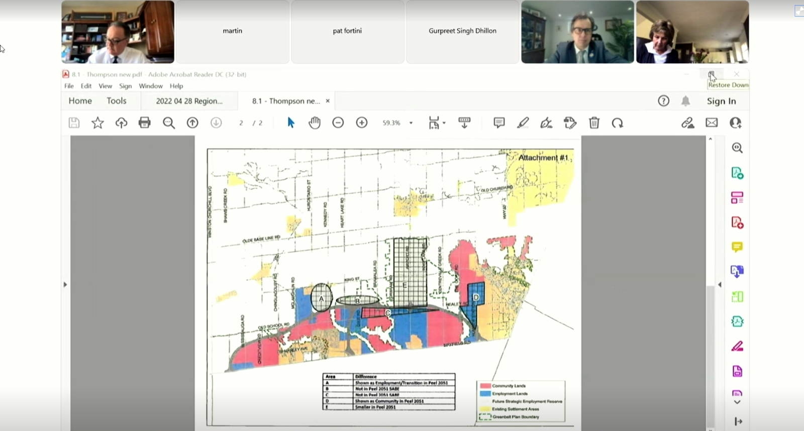
Staff and council members were frustrated by the last second motion Caledon Mayor Allan Thompson presented at the Region’s meeting. It included considerations for the proposed Highway 413, which Regional Council does not support.
(Screenshot)
Thompson explained that Caledon staff came to him at 3:00 p.m. Wednesday before the Regional Council meeting hoping to put through the employment conversions.
“I guess this resolution here I would consider a fairly substantial departure from where we were, where we had been as a regional staff and in shifting that to employment,” Smith said. According to multiple councillors and Smith the motion was not sent to council until Thursday morning.
“This is kind of a sneaky backhanded little trick,” Parrish said of the motion. “All the other motions that were passed today were passed by Adrian… . This is a major change.”
Thompson said multiple times that there was nothing “underhanded” about his failed move.
Parrish ultimately referred the motion back to staff for review.
Email: [email protected]
Twitter: @taasha__15
COVID-19 is impacting all Canadians. At a time when vital public information is needed by everyone, The Pointer has taken down our paywall on all stories relating to the pandemic and those of public interest to ensure every resident of Brampton and Mississauga has access to the facts. For those who are able, we encourage you to consider a subscription. This will help us report on important public interest issues the community needs to know about now more than ever. You can register for a 30-day free trial HERE. Thereafter, The Pointer will charge $10 a month and you can cancel any time right on the website. Thank you
Submit a correction about this story
