
Hope from above: study finds satellites could help Ontario conservation authorities protect wetlands
“Conservation authorities face a practical question: do we need to pay for expensive high-resolution satellite imagery, or can free imagery do the job?,” Toronto and Region Conservation Authority Senior Manager of Ecosystem & Climate Science, Jonathan Ruppert, wondered.
Nearly two years ago, Ruppert along with four other researchers set out to one of Brampton's most ecologically important nature preserves to get an answer to that question at a time when conservationists across Ontario are increasingly being asked to do more with less.
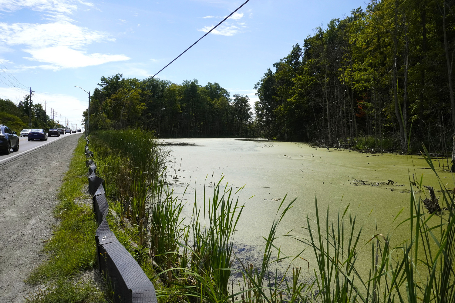
Nature's sponges—wetlands—sit at the edge of subdivisions and highways, connecting land and aquatic ecosystems while filtering water, storing carbon and protecting communities from flooding. Yet, they are among the first ecosystems threatened as Ontario's relentless urban growth consumes more land every year.
While Ontario holds around 24 percent of Canada’s wetlands (six percent of all wetlands on the planet), southern Ontario has lost an estimated 70 percent of its original wetlands with approximately 90 percent of the Greater Toronto Area’s wetlands gone—the highest recorded rate of loss on Earth.
Drained for agriculture, filled for housing developments, slowly fragmented by highways and industrial parks, they have gradually been erased from the province’s landscape even though decades of evidence indicate they perform services that engineered infrastructure cannot.
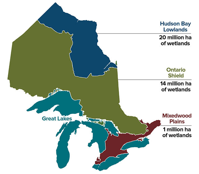
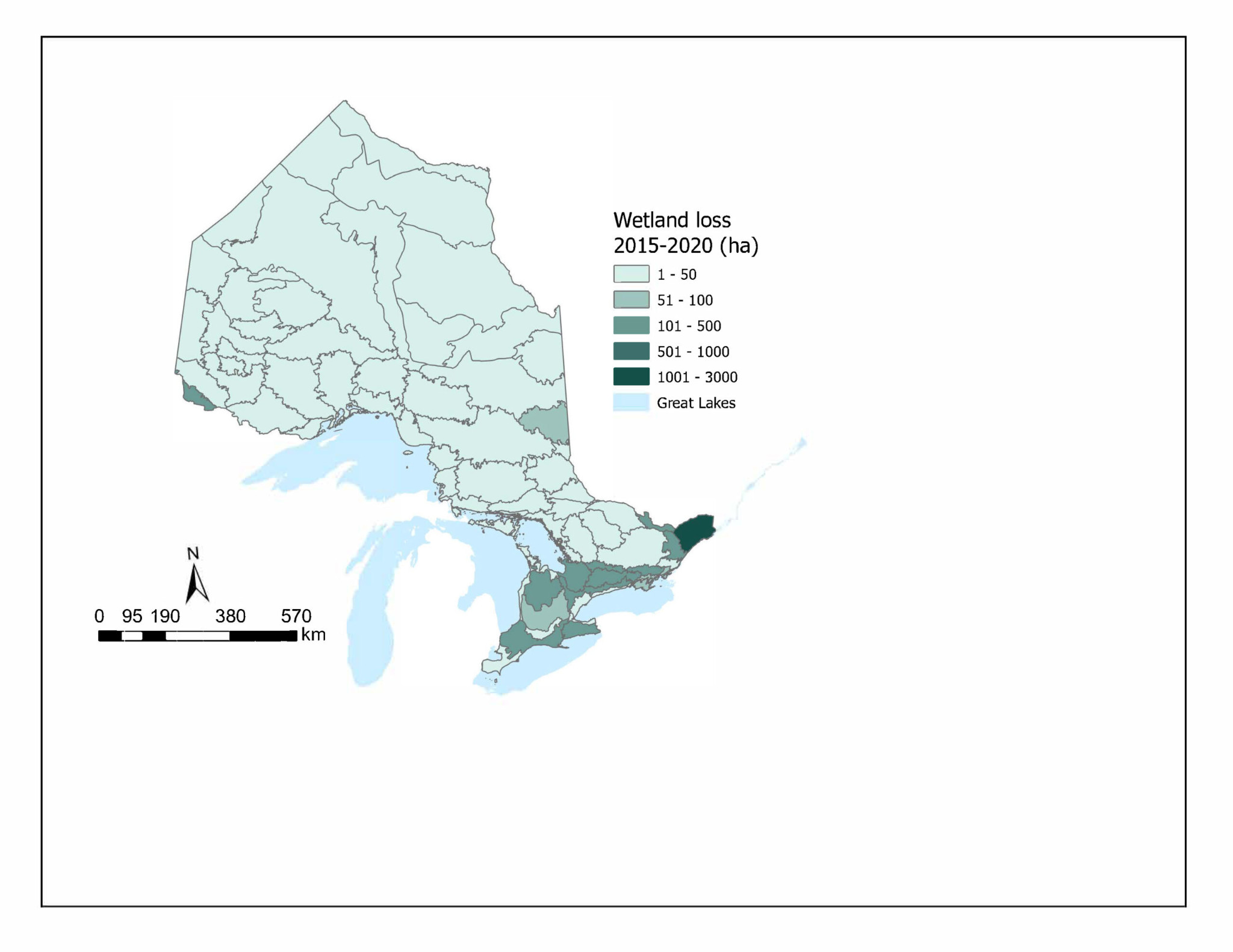
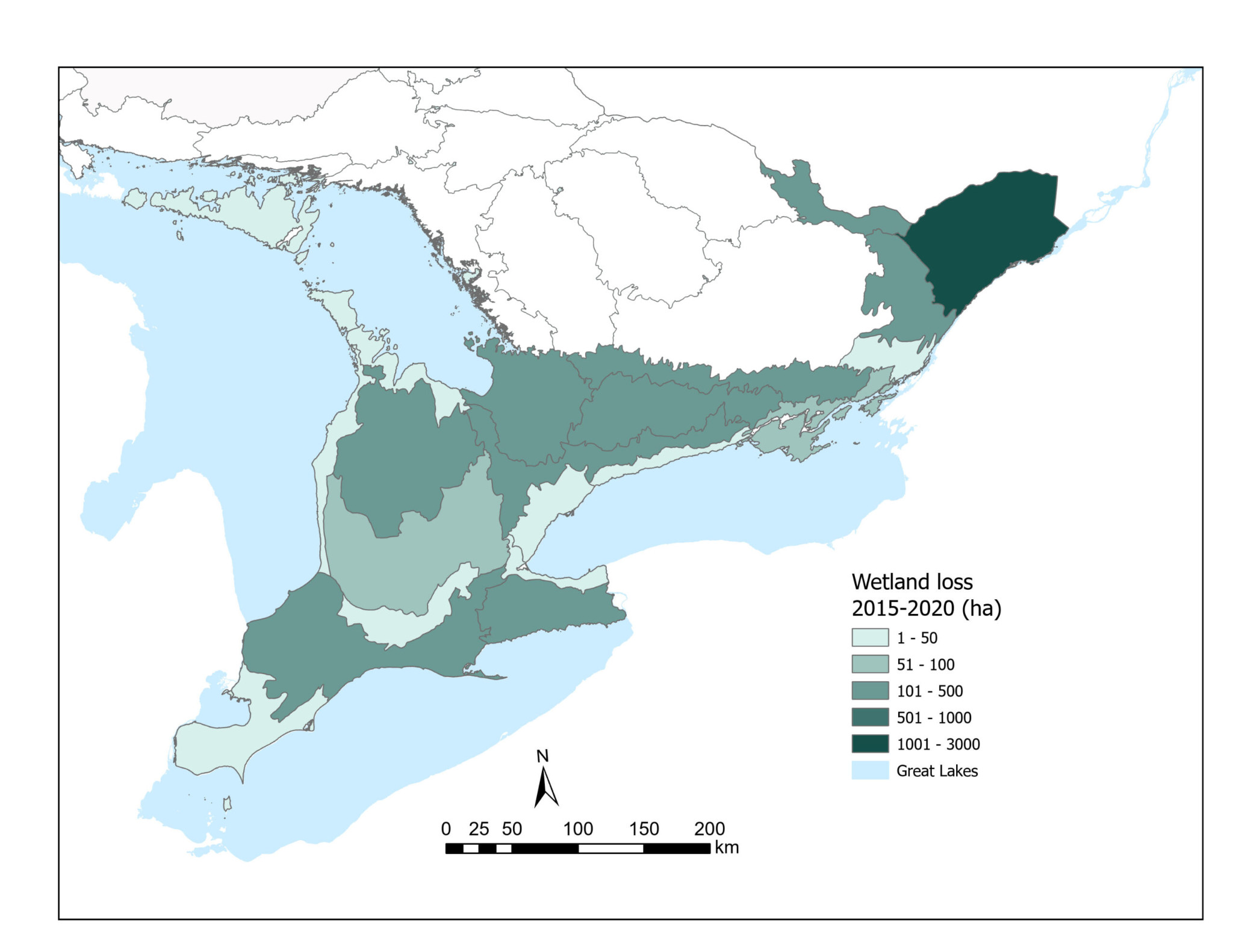
“Wetland loss has been greatest in southwestern Ontario, parts of eastern Ontario, Niagara and the Toronto area, where over 85 percent of the original pre-settlement wetlands have been converted to other uses. While land conversion is the primary cause of wetland loss in southern Ontario, pollution, invasive species, alteration to natural water levels and climate change also pose serious threats,” an Ontario Biodiversity Council report noted.
(State of Ontario’s Biodiversity)
Despite the loss, close to 95 percent of Ontario residents live in watersheds managed by conservation authorities that were created to prevent future disasters after Hurricane Hazel struck Toronto in 1954, a storm that dumped nearly 30 cm of rain, killed 81 people, destroyed bridges, and caused $1.3 billion in property damage.
The Province gave conservation authorities (CAs) the power to purchase land, restrict construction on floodplains by reviewing development applications within its watersheds and manage dams, reservoirs and channels to control floodwaters.
Rather than relying solely on municipalities, Ontario recognized that watersheds do not respect municipal boundaries. Rivers flowing through Caledon and Brampton pass through Mississauga before finally meeting Lake Ontario; decisions made upstream determine the future of downstream communities.
If a developer wanted to continue with a proposal to build in a risky area, despite the denial of a CA, Schedule 6 of the bill allowed the applicant to appeal directly to the provincial government and Queen’s Park had the veto power to order the CA to issue a permit even if their scientists said it was damaging to the environment.
“The gutting of Conservation Authorities shows that this Ontario government ignored the people. It’s a government for land speculators and the worst sorts of developers…[it] takes the province back over 70 years, to a more dangerous time when we didn’t know better,” Environmental Defence’s Executive Director, Tim Gray, said at the time.
But that was just a preview of what lay ahead for Ontarians under Premier Doug Ford’s leadership…
On March 10, environment minister Todd McCarthy and Ontario’s Chief Conservation Executive Hassaan Basit declared that the PCs are moving ahead with a plan to create nine CAs (instead of seven as originally proposed in October) under a new centralized agency called the Ontario Provincial Conservation Agency (OPCA), claiming the move is meant to speed up housing and infrastructure projects.
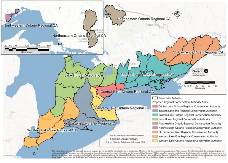
Updated boundaries for Ontario’s nine new regional conservation authorities.
(Government of Ontario)
The announcement was made despite widespread concerns shared by municipal and conservation leaders about minimizing local voices and knowledge. They cautioned against the PC strategy to reduce the regionalized CA system, which gave staff with specialized local knowledge the ability to push back against development proposals and Ford’s own plans for some of Ontario’s most ecologically sensitive areas, slated for highways, mines and other environmentally destructive projects.
“Regional conservation authorities would continue to be independent, municipally governed organizations,” McCarthy noted at a press conference.
“There will be no reduction in staffing levels. And secondly, local expertise will remain central to conservation work.”
However, experts including Ontario Headwaters Institute Executive Director Andrew McCammon are wary that the “devil may be in the details”, which are yet to be released by the province.
“We heard strong support for shared services, updated tools and data. We also heard loud and clear that local knowledge, local priorities and local relationships must remain at the heart of everything we do,” Basit said, referring to the comments received by the province to the bill’s environment registry.
“This new regional structure achieves both. And because of that, consolidation will strengthen the system, not weaken it. By combining expertise across regions, we can put more resources where they matter the most: the front line.”
The province then announced $3 million in funding for the transition annually, in addition to the $20 million announced last year. But critics pointed out the funding was not a “re-investment” since the broader CA budget across the province is expected to eventually see dramatically less money from the PCs; it has been clear over the years that CAs have been grappling with limited funding.
In 2020-21, the province approved $10 million in Water and Erosion Control Infrastructure (WECI) funding for 68 projects across 21 CAs, recognizing the benefit to local communities and to Ontario’s economic recovery. Despite the program being oversubscribed by almost twofold, with an estimated total cost of more than $19 million for 102 project submissions from 30 CAs, the funding levels were subsequently returned to $5 million.
A group of 74 retired political and conservation leaders spoke out about the significant pressure staff continue to face—issues they outlined in a joint letter to the PC government, which largely went unaddressed.
“We asked the province to pause the approval of the proposed regional consolidation and take time to engage in meaningful dialogue, conduct a transparent cost-benefit analysis and develop a reasonable transition where amalgamation is justified,” Ottawa City Councillor Janet Stavinga told The Pointer.
“Our concerns have not been addressed at all.”
Historically, the province funded roughly half the operating costs of CAs while municipalities covered the rest.
That model was altered dramatically in the mid-90s when the PC government led by Mike Harris implemented significant funding cuts to CAs as part of the Common Sense Revolution, reducing provincial support from approximately $50 million to $8 million per year. It forced CAs to cut staffing by 20 to 60 percent and dismantled a provincial conservation authority branch; they were left to develop their own tools and policies.
“Authorities had to pivot and rely more heavily on municipal partners to maintain operations,” Stavinga noted.
“So, it’s frustrating when ministers today say that funding relationships don’t need to change, despite this history.”
While the consolidation for conservation authorities is set to take effect starting in Spring 2027 despite a long list of concerns, scientists have been exploring lower-cost ways to monitor and protect wetlands—and experts at the Toronto and Region Conservation Authority (TRCA) and the University of Toronto's Remote Sensing Lab believe they have found one.
As they searched for a landscape that reflected the environmental challenges facing much of southern Ontario, researchers came across Heart Lake Conservation Area in Brampton.
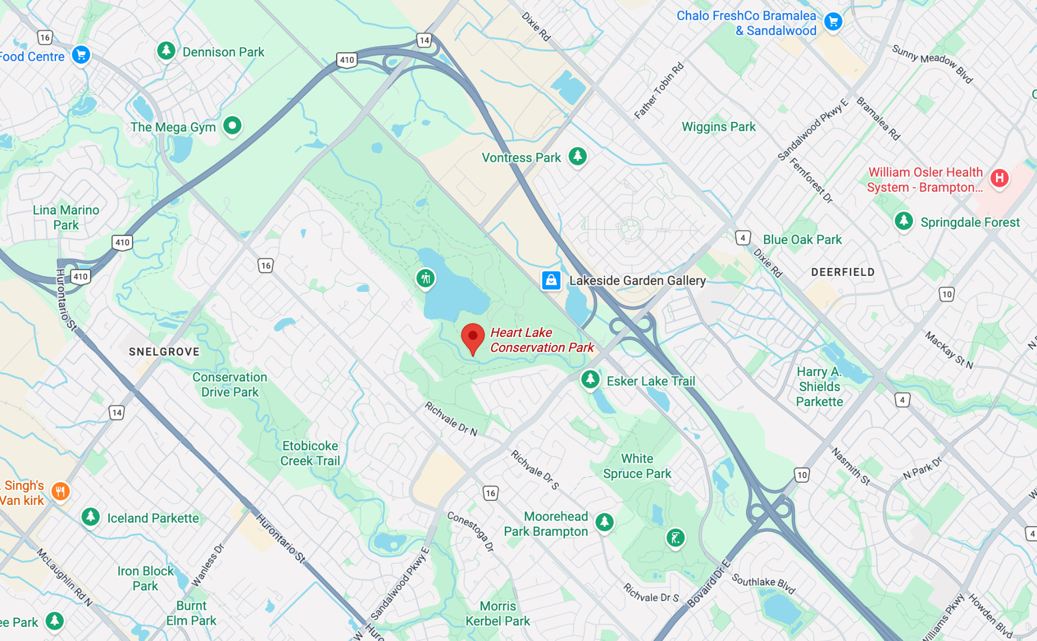

Located at 10818 Heart Lake Road in Brampton, Heart Lake Conservation Area beautifully embodies the intersection of nature and human growth. It protects sensitive ecological habitats like kettle lakes and wetlands for species under threat including the Snapping Turtle, listed as a species of Special Concern under the former Ontario Endangered Species Act.
(Top: Google Maps, Second; Bottom: Alexis Wright/The Pointer)
The 50.7 square kilometre study area contained one of the Etobicoke Creek watershed's largest remaining forest blocks, provincially significant wetlands, kettle lakes, meadows, agricultural lands, streams and urban neighbourhoods swelling at an unprecedented pace, creating a complex mosaic of natural and developed landscapes—making it an ideal location to test whether satellite imagery could reliably distinguish between different types of land cover in a highly fragmented, peri-urban environment.
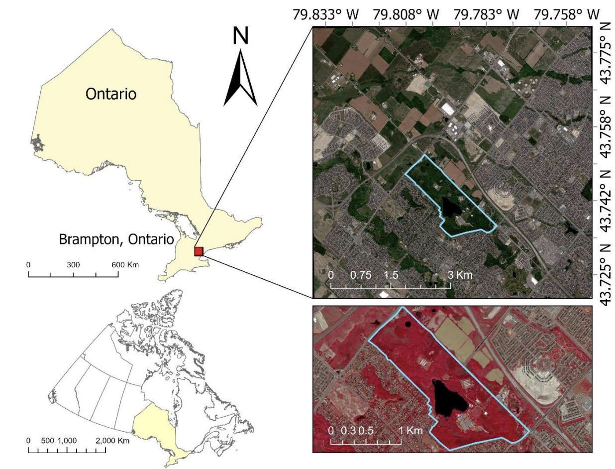
A two-year study published on June 29 focused on Heart Lake Conservation Area in Brampton, where the heart-shaped lake is surrounded by extensive forests and wetlands in a rapidly growing municipality.
(Science Direct)
Heart Lake is made up of multiple wetland types including bogs, marshes and swamps; they often appear similar from above but differ in their vegetation, hydrology and ecological function. Separating these wetland classes has long been one of the greatest challenges in remote sensing for conservation authorities.
Since TRCA has been conducting extensive field surveys and ecological monitoring throughout the conservation area for years, it provided researchers with a wealth of data on observations of vegetation communities, wetlands and land cover that could be used to verify if the satellite classifications were correct.
“However, these ecologically significant natural landscapes face anthropogenic threats from rapid urban expansion,” the study noted.
“Brampton has been a magnet for over 50,000 immigrants between 2016 and 2021, propelling it to become one of Canada's fastest -growing municipalities. Renowned for its advanced manufacturing sector, Brampton hosts major companies in the automotive, food, and commercial sectors.”
Years of rapid development coupled with an annual population growth of four percent have transformed Brampton's landscape, threatening some of the city's most ecologically valuable natural areas including Heart Lake Conservation Area—mirroring conditions CAs across Ontario are increasingly managing where natural ecosystems are embedded within rapidly urbanizing landscapes where development pressure and environmental protection are in constant tension.
After identifying the ideal location, researchers moved to the next step, comparing two different satellite systems: the freely available satellite imagery captured at a ten-metre resolution by Sentinel-2 (operated by the European Space Agency) and the commercial WorldView satellites operated by Maxar Technologies, which provide imagery between 1.2 and 1.8 metres in resolution but require organizations to purchase access.
Conventional wisdom would suggest the sharper imagery should produce better results but researchers found surprisingly little difference.
Using machine learning through a Random Forest classification system, Sentinel-2 achieved an overall mapping accuracy of 91.2 percent compared with 90.5 percent for WorldView imagery.
What improved the performance?
The answer was simple: combining images from spring, summer and fall increased mapping accuracy far more than increasing image resolution since capturing vegetation as it greens, matures and dies back contained more useful ecological information than simply being able to see the landscape in finer detail.
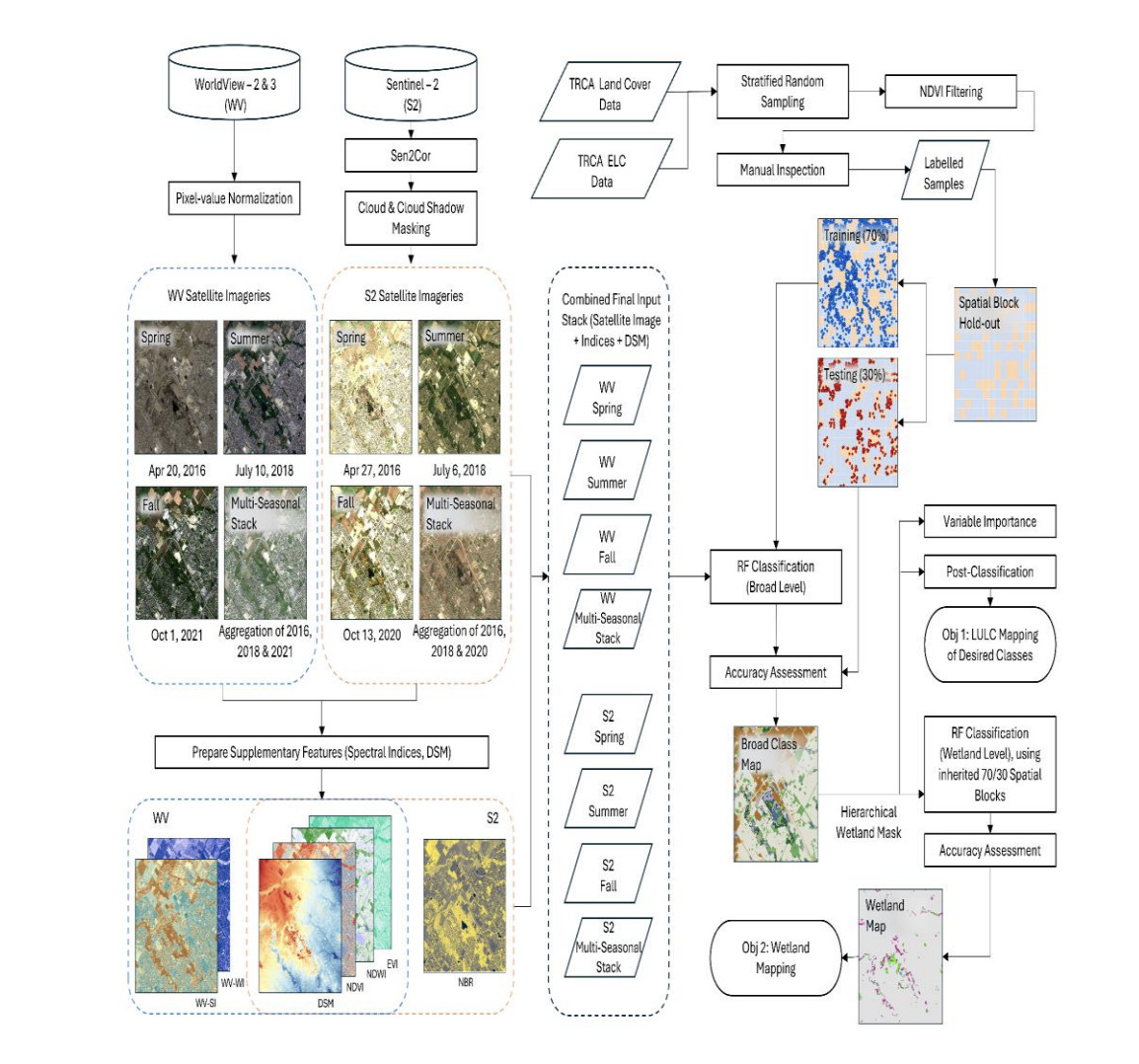
Sentinel-2 showed better results when comparing imagery from different seasons.
(Science Direct)
For Sentinel-2, using imagery from multiple seasons improved accuracy by 5.1 percent over the best individual season while seasonal stacking increased accuracy by 8.6 percent for WorldView.
The free satellite imagery also consistently outperformed WorldView when identifying moisture-sensitive natural landscapes since Sentinel-2 included specialized shortwave infrared (SWIR) and red-edge spectral bands that are unavailable in the standard WorldView imagery tested; it classified wetlands and herbaceous vegetation more precisely despite its lower spatial resolution. For bogs and swamps specifically, Sentinel-2 outperformed the commercial imagery while both systems performed similarly when identifying marshes.
Since the “central motivation” of the study was filling “the gap between what provincial policy demands and what existing mapping products can deliver”, TRCA’s Rupper believes the findings will help lower “the cost barrier for routine wetland inventory and long-term monitoring, especially for smaller agencies or municipalities with limited budgets”.
By lowering the financial barrier to high-quality environmental monitoring, agencies may now be able to track changes in wetlands, forests and surrounding natural landscapes more consistently as urban development accelerates, particularly in the Region of Peel where the province has mandated the construction of 246,000 new homes by 2031 (120,000 units in Mississauga; 113,000 units in Brampton; 13,000 units in Caledon).
Email: [email protected]
At a time when vital public information is needed by everyone, The Pointer has taken down our paywall on all stories to ensure every resident of Brampton, Mississauga and Niagara has access to the facts. For those who are able, we encourage you to consider a subscription. This will help us report on important public interest issues the community needs to know about now more than ever. You can register for a 30-day free trial HERE. Thereafter, The Pointer will charge $10 a month and you can cancel any time right on the website. Thank you
Submit a correction about this story

