
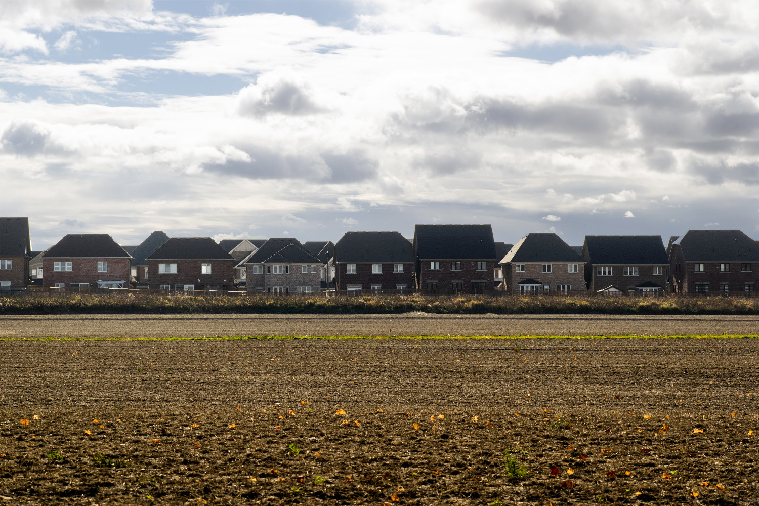
Questions swirl around Caledon’s proposed zoning shift to convert farm land into future homes
Back in 1974, a sweeping provincial restructuring nearly tripled the size of Caledon Township, after parts of Chinguacousy Township north of Mayfield Road, the villages of Bolton and Caledon East, and Albion Township were absorbed into one county, Peel—later transformed into the Region of Peel.
But Caledon’s character was shaped long before that.
First settled in the 1820s by Irish and Scottish immigrants, the community (known over time as Raeburn’s Corners, Charlestown and Caledon) had a rural economy rooted in agriculture and poultry. By 1869, Belfountain became a small village of just 100 residents along the expansive Credit River, connected to nearby communities like Erin and Georgetown only by stagecoach routes through the countryside.
At the time, land was sold for about $20 an acre — valued for what it could grow, not what it could become.
More than a century later, the same land, still among the most fertile in Canada, is facing fierce development pressures — parcels once sold for modest sums are now valued in the hundreds of thousands and millions as the provincial government, failing to meet its housing targets, continues to push municipalities to build 1.5 million homes by 2031.
What remains unchanged is residents’ love for the land that runs as deep as Caledon’s lush green fields, pristine waters and open skies — reflected in the farming traditions that have long defined life in the town.
At a statutory public meeting on April 7, residents, local advocacy groups and the Town of Caledon’s planning officials debated a proposed zoning bylaw amendment that would apply a Future Development (FD) label to approximately 9,000 acres of land already identified for long-term urban growth.
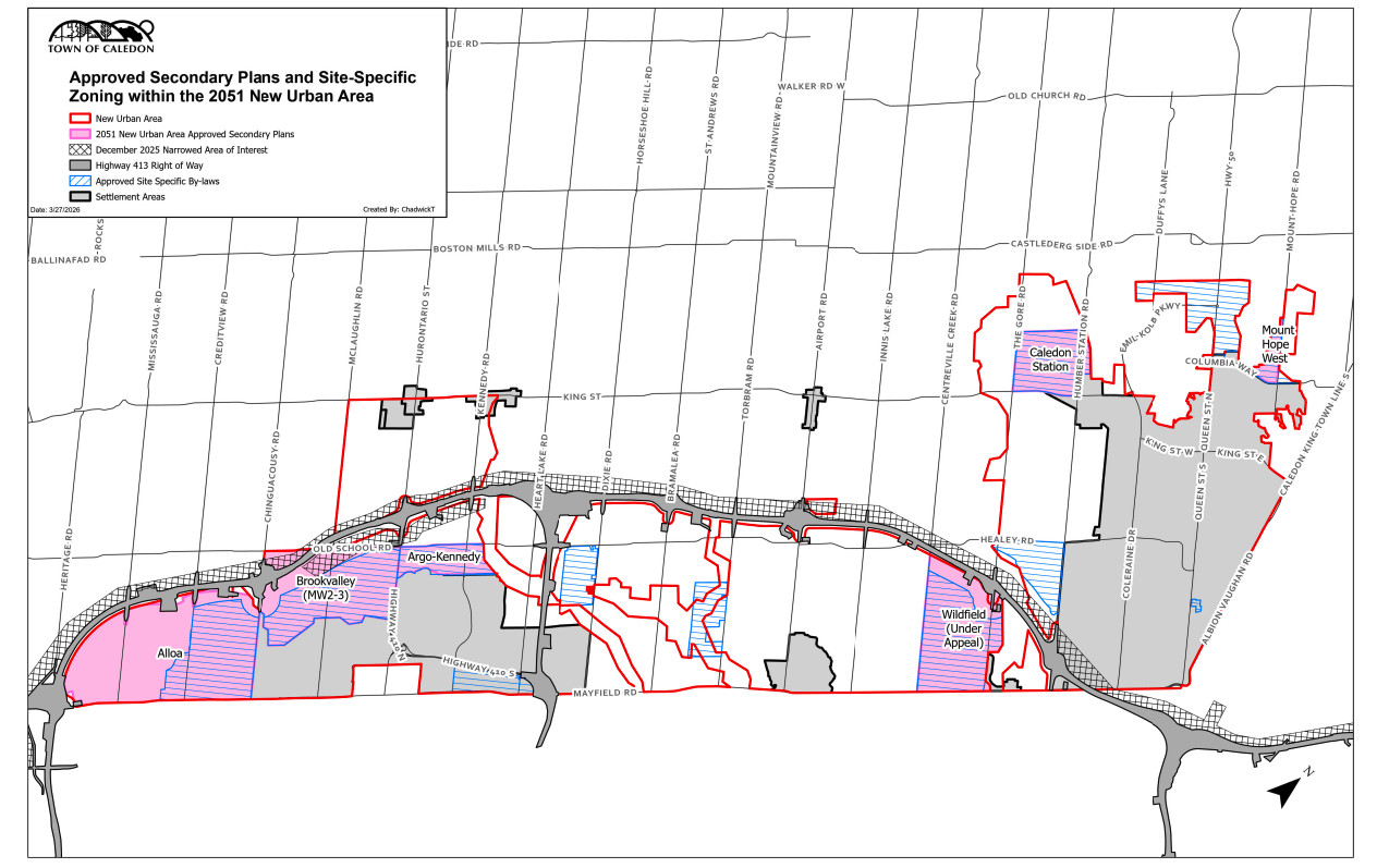
Of the 9,000 acres proposed to receive a Future Development zoning label, about 5,000 acres were already prematurely zoned for urban residential use by Caledon council in 2024—an additional 4,000 acres have been added in the recent proposal. It includes lands near the future Highway 413 route.
(Town of Caledon)
For the Town, the move is about transparency and planning clarity. For locals who lost trust in Mayor Annette Groves after she pulled a similar move in 2024 by prematurely approving the rezoning of land for 35,000 homes, it is a premature signal—one that risks locking in the destruction of critical farmland decades before development is necessary.
“This is a lot of land,” Democracy Caledon president Debbe Crandall said, noting the additional 4,000 acres of land in question surround roughly 5,000 acres that Caledon council prematurely zoned for urban residential use in 2024 — also, the subject of Democracy Caledon’s legal challenge against the Town since December that year.
She framed the move as both unnecessary and potentially harmful as it risks cementing an urban destiny for farmland that may not be needed for decades to come, if at all.
“I don't think the majority of this council has demonstrated that their actions are for the benefit of the town or the residents of Caledon.”
According to a staff report presented at the meeting, the proposal is a Town-initiated zoning amendment tied to the Future Caledon Official Plan, approved by the province on October 22. The plan maps out how the municipality will accommodate population and employment growth through 2051, directing most of that growth to designated New Urban Areas.
Many of those lands are currently zoned for agricultural use.
The proposed “FD” label would not immediately change what landowners can do with their properties. Instead, it would be appended to existing zoning categories (turning A1 agricultural zoning into A1-FD) to signal that the land is intended for future urban development.
“This information will allow landowners and prospective purchasers to factor the long-term planning objectives into financial decisions including land acquisition and construction plans on their properties,” Town of Caledon Senior Planner, Tanjot Bal, said at the public meeting.
In simple terms, the Town’s rationale appears to be twofold: to signal to prospective buyers that the land is slated for urbanization and to alert current landowners that future development permissions may apply when seeking building permits.
“There’s some logic to it,” longtime planner and chief architect of the Greenbelt, Victor Doyle, told The Pointer.
“I don't really trust the mayor, given what has gone down there.”
Two years ago, Mayor Groves used her Ontario-appointed strong mayor powers to fast-track development approvals tied to roughly 35,000 homes across 12 projects in the community. But Doyle cautioned that the timeline for much of this buildout remains highly unpredictable.
“Some municipalities use this type of advanced notice on lands that have been urbanized, that won't be developed for a long, long time,” Doyle noted. “But there's no guarantees.”
He pointed out that most of the lands are likely already in the hands of development interests and sophisticated buyers would already be aware of long-term designations. As a result, the “buyer beware” rationale may not carry much weight.
In routine scenarios such as farmers adding structures or homeowners seeking building permits for renovations or new builds, zoning and official plan designations would typically already be reviewed through standard due diligence and the building permit process with lawyers and building officials flagging applicable restrictions.
If the proposed changes are adopted, how the policy functions will remain critical to the town’s future. Doyle explained a landowner group seeking to preserve agricultural use indefinitely could, in theory, apply to remove the “future development” designation but would likely face resistance given the municipality’s stated planning direction.
“So, it does create a hurdle in that regard,” he said.
On the flip side, any proposal to develop or intensify land use would still need to proceed through the full planning process including official plan and zoning amendments.
The draft bylaw, first put forward on March 12, would have rezoned the area entirely to future development, but the Town has since shifted its approach: it is now proposing to retain the existing agricultural zoning in most areas and add the FD label alongside it.
Former Ward 1 Councillor and Caledon resident Ian Sinclair, who has closely followed planning decisions in the area, identified three key issues with the proposal: need, an obscure aspect of the Ontario Building Code and concerns around the lack of prior notification to the public.
Much of the contested land sits in the whitebelt, areas outside the provincially protected Greenbelt (established by former Ontario Premier Dalton McGuinty's Liberal government in 2005) but within settlement boundaries earmarked for eventual growth.
That designation alone has already shaped land ownership patterns with much of the land in the whitebelt now in developer and/or investor hands.
“There’s no provincial designation or plan for the whitebelt,” Sinclair said, noting that long-standing discussions around regional and local official plans have left residents with a general awareness that these lands are earmarked for growth.
“The FD suffix raises a fundamental question of necessity…to simply warn people about future development intentions.”
While the Town maintains that the FD suffix does not change land-use permissions, Sinclair argues that the implications may be more complex, particularly when viewed through the lens of Ontario’s building regulations.
Under Ontario Regulation 305/03 under the province’s Building Code Act, applicable law requires a chief building official to ensure that any building permit complies with other relevant statutes, plans and regulations before approval.
Sinclair explained that applicable law spans a wide range of legislation, from the Planning Act and Ontario Heritage Act to conservation authority regulations and environmental assessment requirements, making the permitting system highly complex.
“You don’t want a chief building official issuing a house permit in an area without knowing whether there are development constraints or required approvals,” Sinclair said, citing examples such as the Niagara Escarpment Plan and Oak Ridges Moraine regulations.
The proposed bylaw introduces a requirement for landowners to “consider” long-term planning objectives when making decisions.
“But there’s no definition of what that entails,” he observed.
It could create uncertainty for homeowners and landowners navigating routine building permits, even where no actual change in permitted use is intended. It could also complicate financing, as lenders assess risk tied to properties flagged for future redevelopment.
Another point of contention is how the public meeting itself was communicated.
Under the Planning Act, the Town placed a notice in a local newspaper and on its website. But because no development is immediately proposed, it did not follow its own enhanced notification requirements, which include mailing notices to landowners within one kilometre of the affected area.
For a proposal affecting thousands of acres with long-term implications, Sinclair views this as a missed opportunity.
“This would have covered almost all of the whitebelt, possibly at least two thousand different letters to all the landowners,” he added. “And staff didn't think it was necessary to do this, but they gave no indication why.”
Beyond planning, there is little detailed information on the environmental impacts of the proposal.
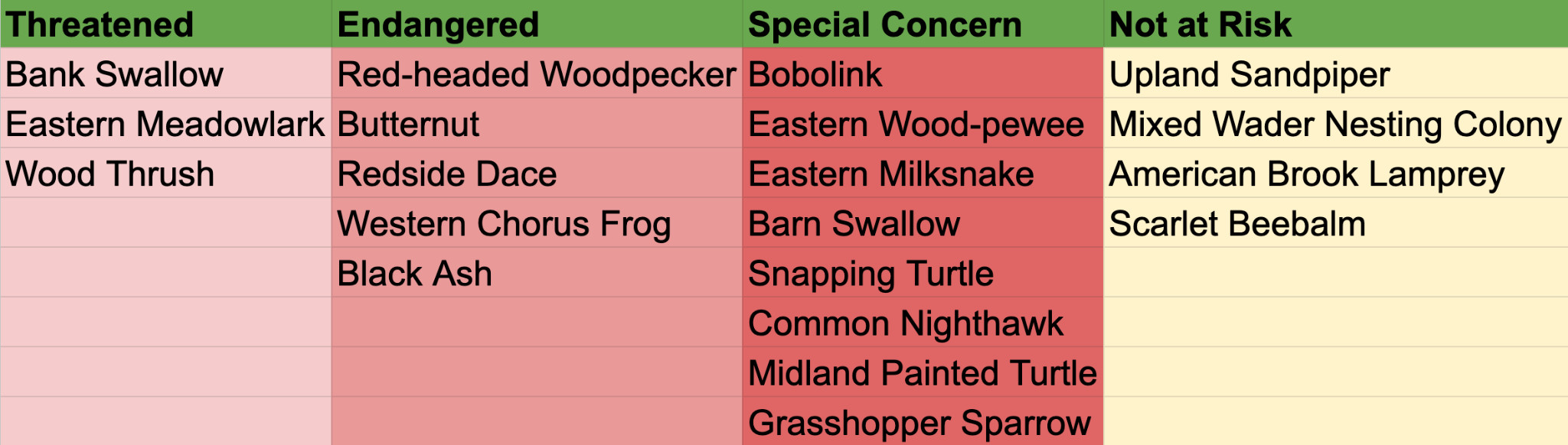
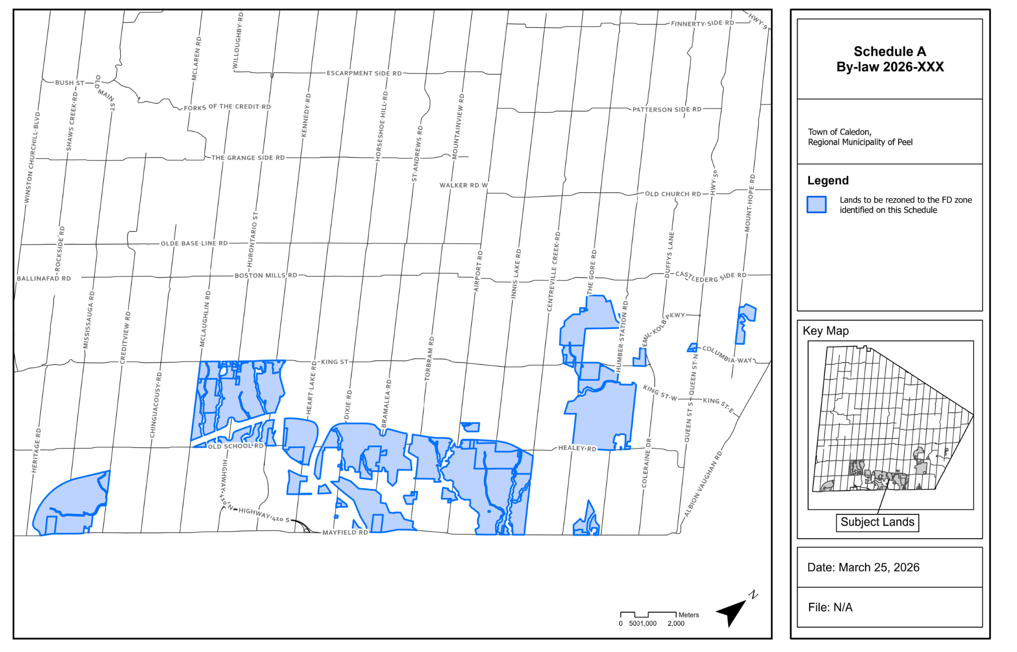
At least 20 species, including many at-risk, have homes in and around the 9,000 acres of land included in the proposed new bylaw for future development.
(Anushka Yadav/The Pointer)
An investigation by The Pointer using data from the province’s Natural Heritage Information Centre (NHIC) found at least five federally threatened species, three endangered species, and six species of special concern in and around the lands in question — the list is longer for provincial species but with the latest repeal of the Endangered Species Act under Bill 5, many have lost that protection. A previous investigation by The Pointer of the original plan pushed by Groves to rezone parts of these lands for 35,000 homes found at least 24 species at risk rely on lands in the area.
“They completely eviscerated the old act, and now the protections are far less,” Doyle said. “Developers can pay to do compensation somewhere else to eradicate whatever's on the land they want to develop…The pay-to-slay framework is just archaic if you're actually protecting endangered species.”
While some environmentally sensitive lands like those owned by the Toronto and Region Conservation Authority are excluded from the rezoning, broader ecological considerations appear largely deferred to future studies.
For critics, that omission risks setting the town in a direction without fully grappling with the consequences.
Ultimately, Doyle questioned the logic of continued residential construction in areas slated for future change. “If somebody owns a lot and they want to build a new house—there are some big new homes right where the 413 is supposed to go—I just think, who would spend that kind of money to build there, given what’s going to happen?
“But people do, not just in Caledon. It doesn’t really fit with what the future urban fabric is going to look like. On the surface, it seems to make some sense too because you need a building permit.”
He questioned what the town is ultimately achieving with the change, suggesting the approach effectively communicates the same intent without altering the underlying zoning. He advocated for maintaining agricultural zoning with a designation marker that may be sufficient to reflect long-term planning intent.
The Town’s position aligns with provincial policy, which requires municipalities to plan for 20 to 30 years of growth. The Future Caledon Official Plan designates sufficient land “to accommodate approximately 175,000 people and 19,000 supporting jobs” by 2051.
Residents say they do not oppose growth, but want to see “well-planned, sustainable, smart urban growth” paired with stronger protections for prime farmland. Ward 1 Councillor Lynn Kiernan shared that since the bylaw was put forward, staff and council have already received multiple truck parking permit proposals.
“These are Class 1–3 agricultural lands,” Crandall said.
“And here we are suggesting that the best use of that land is to urbanize it. And that's what we are challenging…We need to create, promote and protect a ‘Foodbelt’ for all Caledon farmlands outside the Greenbelt.”
On May 13 last year, Ontario Green Party leader Mike Schreiner put forward Bill 21, dubbed the Protect Our Food Act, at Queen’s Park to protect farmland from “unnecessary sprawl”.
“Ontario farmers grow more than 200 different crops on 49,600 farms across the province, and the sector contributes over $52 billion to the provincial economy, employing over 875,000 people—1 in 9 Ontario jobs,” Schreiner said in a statement.
“All of that is at risk because Ontario is losing 319 acres of farmland every day.”
If passed, the Protect Our Food Act would establish a permanent Foodbelt to safeguard agricultural lands from development pressure. It also proposes a task force of farmers, agricultural experts and land-use planners to develop recommendations for a long-term Foodbelt Protection Plan.
Democracy Caledon will soon be asking the Town of Caledon to support the legislation.
“We need to make a strong statement as a municipality that we have a responsibility to use some of the land to grow food. This is about growing food for people to eat,” Crandall said. “But if you immediately say that anything within this urban settlement area boundary is going to be urbanized, I think that is unrealistic in today's climate — political, economic as well as environmental.”
Staff will come back with a finalized draft bylaw for the zoning amendment before it goes to council for a vote.
Email: [email protected]
At a time when vital public information is needed by everyone, The Pointer has taken down our paywall on all stories to ensure every resident of Brampton, Mississauga and Niagara has access to the facts. For those who are able, we encourage you to consider a subscription. This will help us report on important public interest issues the community needs to know about now more than ever. You can register for a 30-day free trial HERE. Thereafter, The Pointer will charge $10 a month and you can cancel any time right on the website. Thank you
Submit a correction about this story
