

11 years, 2 destructive floods, millions in damages: why hasn’t Mississauga moved quicker to protect residents?
It was a nightmare version of déjà vu for some Mississauga residents on July 16th.
The rain poured down and the water level of Etobicoke Creek continued to creep upward, first lapping against its muddy banks before rising through thick reeds and grasses and eventually spilling free.
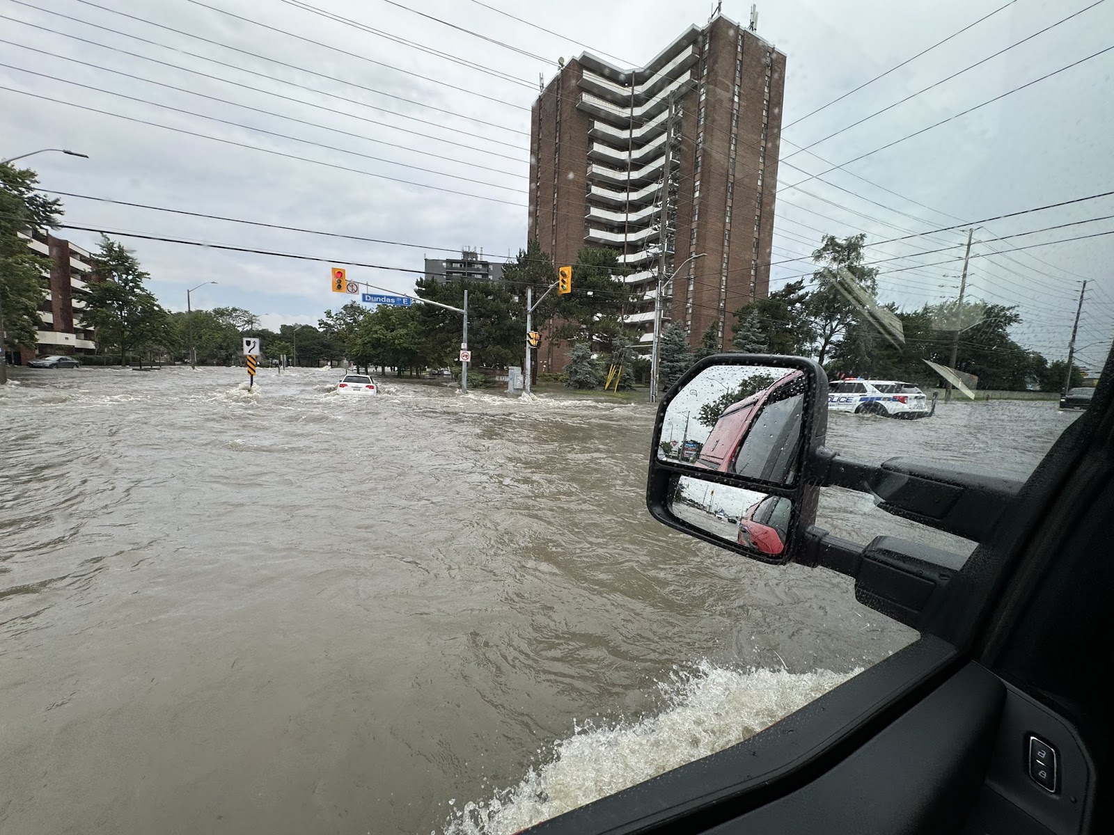
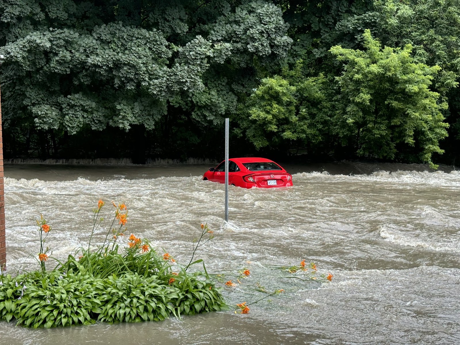
Images quickly began appearing on social media of cars navigating streets flooded with water that nearly reached the tops of their tires. People were being evacuated from their homes, water cascaded into basements and power flicked off.
For residents in south Mississauga, the experience is all too common.
The July 16th flooding was eerily similar to a storm that walloped the city just over a decade ago. In 2013 heavy rains triggered flooding in many of the same locations, causing $932 million worth of damage across Mississauga, Brampton and many other parts of the GTA. A report released a year later by Amec Environment & Infrastructure Inc. revealed 138 milimetres of rain fell in about 10 hours — representing a fifth of the city’s yearly rainfall, according to data from the Toronto Pearson weather station.
It doesn’t end there. In August 2005 a storm dumped 130 millimeters of rainfall which caused approximately $500 million in damages. Then in August 2009, the City received 120 millimeters of precipitation and another $500 million bill.
A report released earlier this year from the Insurance Bureau of Canada revealed that, for the second consecutive year, Canada exceeded $3 billion in insured damage from severe weather events, primarily from flooding.
After the 2013 event, the City of Mississauga began to think differently about how to manage its stormwater. The “100-year storm” was no longer happening every century and climate change was making it all but a certainty that increased precipitation and flooding were here to stay.
A City of Mississauga spokesperson previously told The Pointer the flood “reinforced the City’s need to formally maintain and increase investment in our aging stormwater infrastructure,” and make flood prevention a top priority.
The City is spending millions of taxpayer dollars annually to upgrade its stormwater infrastructure. But has the system adapted quick enough?
Seemingly not. Images of the destruction from the 2013 storm and the July 16th flood show almost identical scenes at Mississauga’s Dundas Street and Queen Frederica Drive intersection. The heavy rainfall caused the nearby Etobicoke Creek to overflow, sending water onto cars, homes and businesses that were unfortunate enough to be caught in its path. The financial toll of the damage has yet to be tallied.
It was a record-breaking rainfall for that day. One that left approximately 50 cars stranded on Queen Frederica Drive in Mississauga. Reports of manhole covers lifting and drivers trapped in their cars filled the call lines for Mississauga Fire and Emergency Services and Peel Regional Police who spent the day responding to cries for aid across the city. Residents at Tyndall Seniors Village were evacuated to safety from their flooded nursing home, with reports of three to four feet of water inside the main floor of the building. The rescue mission saw more than 100 residents moved out of the home, both by raft and foot once the water diminished.
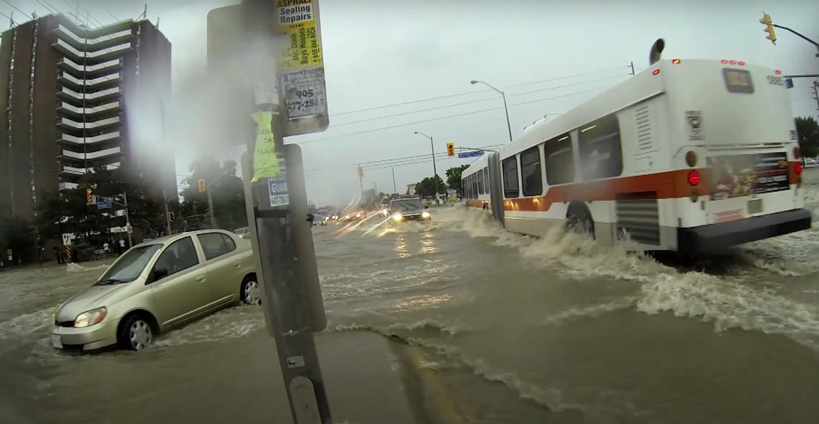
2013
2024
TOP: The intersection of Dundas Street and Queen Frederica Drive during the flood in 2013. (YouTube)
BOTTOM: The same intersection 11 years later. (X/Twitter)
The situation has left many residents frustrated, and those with flooded basements, left holding a bill for repairs that reaches into the thousands of dollars.
“Despite the passage of time and advancements in infrastructure, the recurrence of such a disaster indicates that more robust measures are needed to safeguard our community,” resident Winston Harding writes in a letter to councillors urging the City to construct a retaining wall along Etobicoke Creek to hold back future floodwaters. “The implementation of such preventative measures is crucial for the safety and wellbeing of our community. By taking proactive steps, we can avoid the recurrence of such devastating events and provide residents with the assurance that their property and lives are protected.”
The severity of the storm has prompted a motion from Councillor Chris Fonseca, who represents one of the areas hardest hit by the flooding, to be presented to Mississauga City Council on Wednesday. It requests staff report to council in the fall with options on how to best mitigate the damage from any future storm events. It also asks that the City continue to partner with the Region of Peel and surrounding conservation authorities on finding solutions to mitigate flooding and provide flood protection to residents and businesses.
City staff will not have to look far for answers on how to fix the issues in Mississauga’s south end. It has been studied several times in recent years.
In 2021, the City completed the Dixie Dundas Flood Mitigation Study, which determined that replacing the Dundas Street East crossing with a larger bridge structure is the best approach to eliminate the upstream spill to Queen Frederica Drive. High-level cost estimates, which includes bridge and road work as well as floodplain improvements, put the price tag for the upgrade between $8.3 million and $9.5 million.
“This is a large-scale, long-term infrastructure investment that is fully funded in the City’s Capital Plan through the Stormwater Charge,” a City spokesperson explained. The project is currently in the detailed design phase. It’s unclear when construction is planned to begin.
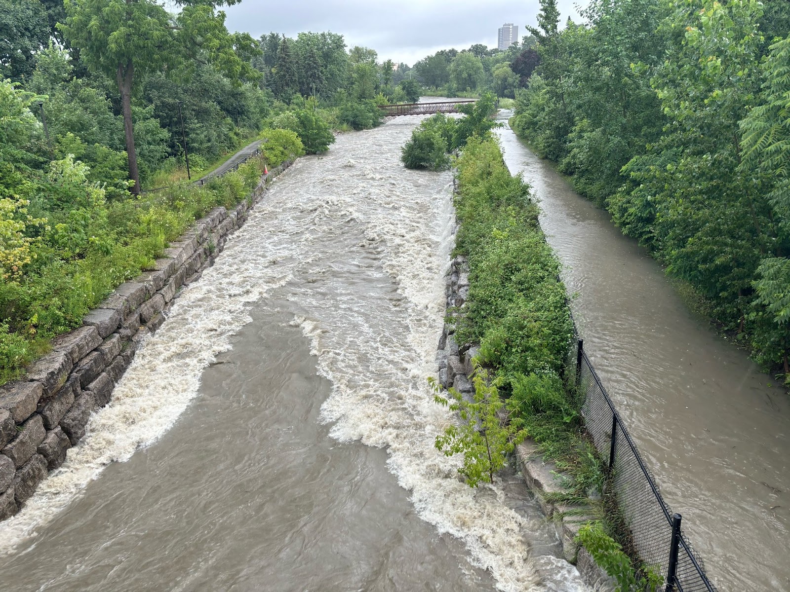
An environmental study of the project released last month revealed the Little Etobicoke Creek watershed has experienced flooding and erosion concerns dating back to the 1970s. Primary river spill occurs upstream of Dixie Road near Queen Frederica Drive, where flood waters leave the creek and flow south through approximately 1,000 commercial and industrial businesses and residential homes. This, the study highlights, creates “extremely unsafe conditions for vehicle and pedestrian traffic.” Flooding in this particular area is caused by “an undersized main channel and floodplain, undersized bridges and culverts, and large contributing upstream flows that have intensified through the effects of upstream urbanization.”
Because of its susceptibility to flooding, the area of Dixie Road and Dundas Street East were designated as Special Policy Areas (SPAs) by the province in the 1980s. The SPA designation limits development within an area that was built around a flood plain. The Toronto and Region Conservation Authority has also designated lands associated with the project area as flood vulnerable, with a high priority for mitigation.
The longstanding classification indicates City staff and elected officials have been aware of this areas vulnerability to flooding for decades. Why has more not been done by the City in that time to mitigate the problem?
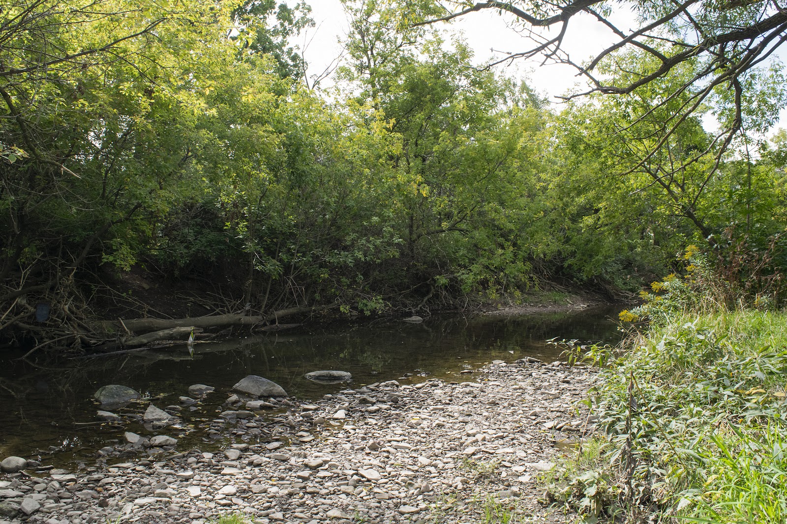
The Little Etobicoke Creek watershed is the primary source of the spillover that causes flooding in the Dixie-Dundas area.
(Alexis Wright/The Pointer Files)
Mississauga has several infrastructure programs designed to mitigate flooding, but with a strict budget overshadowed by a growing infrastructure gap, it leaves the municipality with limited resources to respond to these extreme weather events, which are becoming increasingly common due to climate change.
Climate projections from the Region of Peel highlight that the amount of precipitation is increasing, with more severe and consecutive rain events anticipated in the future. This increase in frequency is putting more pressure on municipalities to expand stormwater management capacity to reduce potential flooding.
Managing stormwater is especially crucial in Mississauga which is not built to withstand these extreme weather events. Its largely urban, concrete design is a key contributor to its vulnerability to flooding during heavy rainfall. Hard asphalt and concrete surfaces that cover large parts of the city puts the municipality at greater risk as heavy rainfall cannot soak into the ground. These impenetrable surfaces cause the water to pool or flow off land more rapidly, generating heavy stormwater runoff and increasing the potential for flooding and erosion.
Meanwhile, Mississauga is home to five major watersheds, including: the Credit River, Humber River, Etobicoke Creek, Mimico Creek and Sixteen Mile Creek. The city’s concrete makeup, paired with its surrounding waterways, makes the municipality extremely susceptible to flooding.
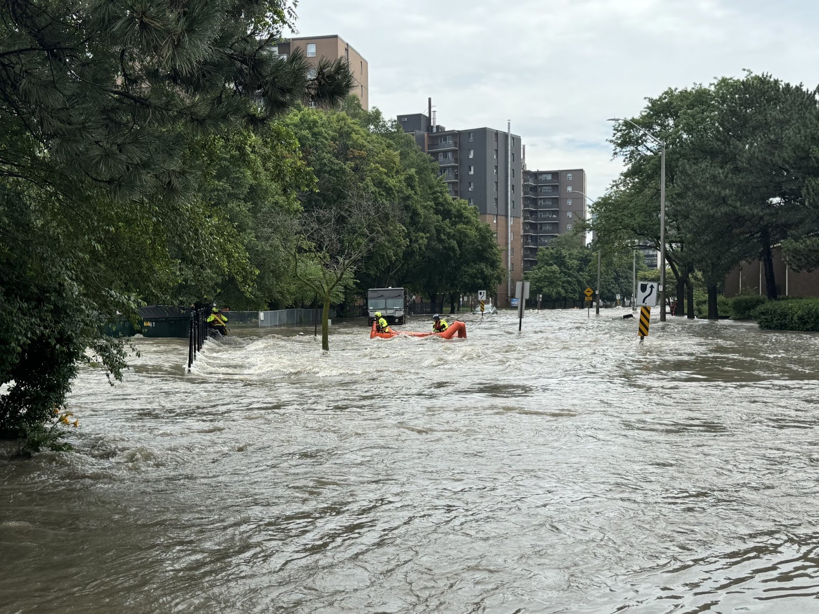
The July 16th flood turned roadways into rivers and submerged cars across Mississauga and many other parts of the GTA.
(Mississauga Fire and Emergency Services/X)
Mississauga’s climate projections for 2050 are already showing severe weather events every six years as opposed to a previously anticipated 40 years, and 70 mm more in annual rainfall, according to the City’s Climate Change Action Plan.
This increased flood risk could create cascading consequences for the City, including damage to electrical infrastructure resulting in blackouts; increased exposure to illness and pathogens; and stormwater and storm runoff causing flooding or washing out roads and basements in low lying areas, with economic impacts.
“The systems, infrastructure, and population characteristics that contribute to a functioning city are dynamic and often interconnected; failure of one system can have a cascading effect on the failure of other systems,” the Action Plan states. “Localized flooding can saturate and exceed the capacity of local stormwater infrastructure leading to disruptions in the road network — such as road closures, washout conditions, road blockages (e.g. downed trees), and slippery road conditions — which in turn can impact local emergency services.”
“These impacts, if not mitigated or planned for in advance, can have substantial economic, environmental, and social consequences.”
Along with the challenge of trying to determine just how much capacity the stormwater system will need to handle the storms of the future, municipalities also must work out how to pay for the necessary upgrades.
In June 2023, the City of Mississauga approved Build Beautiful, the City’s official Stormwater Master Plan. It outlines a framework of actions to guide stormwater management systems and infrastructure investments in the short and long term. The strategy laid out 22 actions with recommendations for managing stormwater.
It remains unclear what the total costs of damages from the July 16th storm will be. A City spokesperson said staff are still assessing the financial impact for the municipality.
(Mississauga Fire and Emergency Services/X)
This includes implementing a stormwater charge — something Mississauga has been a leader in the province on — to generate funding for ongoing system management and investment. The estimated fees for 2024 for smaller residential units are $84.21, while costs for medium homes are estimated at $120.30 and $144.36 for larger homes. The stormwater charge generated $44.6 million in revenue for the City in 2022 (the latest available data). This was estimated to increase to $47.3 million by 2025.
The City also has plans to explore the use of green infrastructure to manage stormwater (e.g., permeable paving, blue roofs) and develop neighbourhood-based flood mitigation strategies (for urban overland and sanitary flooding) to identify opportunities to decrease flood risk.
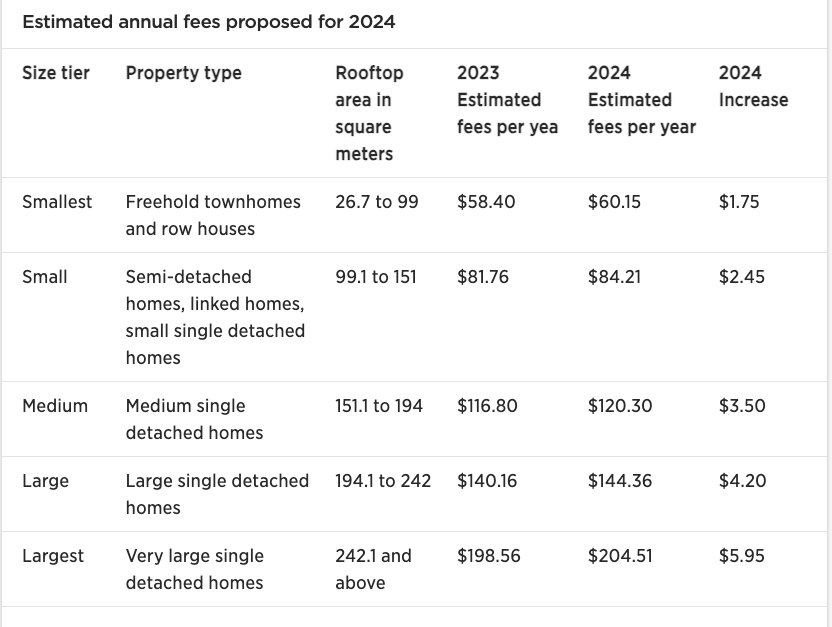
Estimates of the annual stormwater charge for Mississauga residents based on the size of their property and rooftop area.
(City of Mississauga)
“As Mississauga continues to grow and evolve, the City’s stormwater system faces more pressure to accommodate increased population and additional stormwater runoff from both greenfield and intensified development, as well as challenges associated with aging infrastructure,” the City’s master plan states.
With a drainage system spanning 1,911 kilometres worth of sewer pipes, it is an impossible task to update the City’s entire stormwater system all at once, which includes 270 kilometres of ditches, 150 kilometres of creeks and 52,000 catch basins, all of which drain into Lake Ontario. In 2024 the City invested $33.7 million of its capital budget toward stormwater with plans to invest $342.5 million over the next decade. On average, the City forecasts spending $51 million per year on its stormwater pipe infrastructure, according to the document. To ensure stormwater pipes are replaced at the end of their useful life, an additional $30 million per year from 2024 to 2123 is required to fully fund the City’s stormwater pipe program.
As multiple financial pressures continue to weigh on the City’s budget, it remains unclear what the added costs of last week’s flooding will bring. In the days that followed the relentless downpour, emergency crews and city staff continued to responded to flooding complaints, dislodged maintenance holes, uprooted manhole covers and catch basins that had become obstructed, but the severity of the damage has yet to be determined.
Asked whether there are any initial cost estimates, a spokesperson said the City is still assessing the financial impacts to the municipality.
Email: [email protected]
Twitter: @mcpaigepeacock
At a time when vital public information is needed by everyone, The Pointer has taken down our paywall on all stories to ensure every resident of Brampton, Mississauga and Niagara has access to the facts. For those who are able, we encourage you to consider a subscription. This will help us report on important public interest issues the community needs to know about now more than ever. You can register for a 30-day free trial HERE. Thereafter, The Pointer will charge $10 a month and you can cancel any time right on the website. Thank you
Submit a correction about this story
