
Brampton’s Riverwalk master plan promises to breathe life into the city centre; construction to start in 2024
The City of Brampton is intrinsically linked to the watercourse through the Etobicoke Creek corridor. It had provided sustenance, transportation and a power source for local industry. It has also been the cause of a constantly looming flood threat.
This is why the Riverwalk project was conceived.
For the last 70 years the City has been handling the risk of water rising above the creek’s banks by diverting it around the town through a concrete-lined bypass channel that has protected the area from flooding, but a provincial Special Policy Area (SPA) designation due to the continued threat has hurt the city’s ability to redevelop its outdated downtown core.
According to the City of Brampton, under current and forecasted conditions, the bypass channel doesn’t do enough to prevent the area from being vulnerable to flooding.
In 2014, Brampton Council approved the Downtown Etobicoke Creek Revitalization Feasibility Study that included an urban design vision for the area. In 2018, a subsequent, more detailed feasibility study was completed which reiterated success of the urban vision was tied to the removal of flood risk in the downtown area.
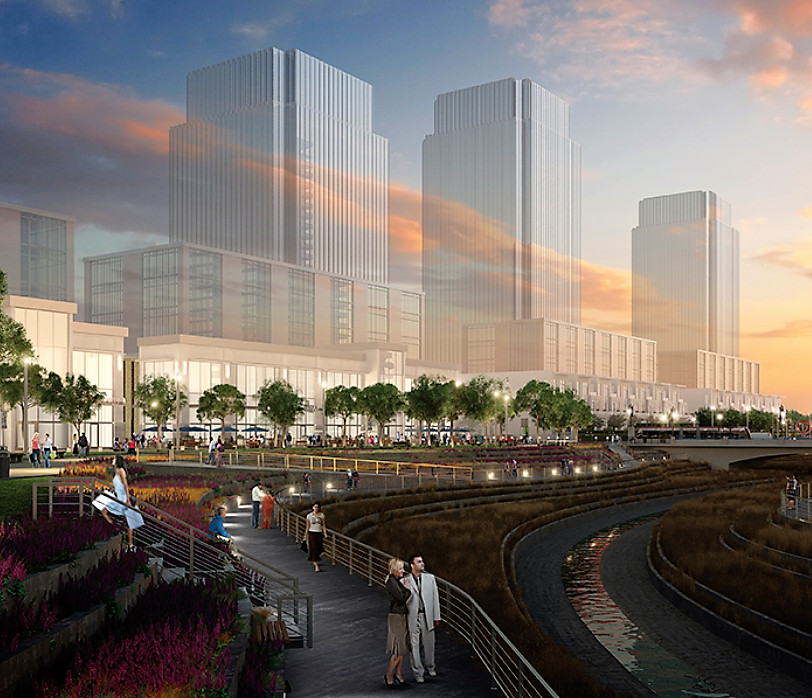
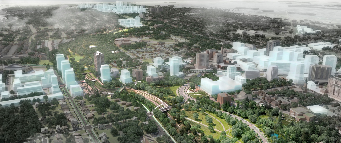
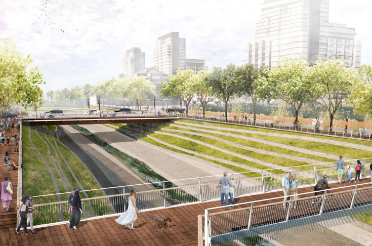
A conceptual rendering of Brampton's future Riverwalk.
(City of Brampton)
Following this, an Economic Development Study was completed to support the case for investing in the Riverwalk, and concluded every dollar invested would result in a 700 percent return on investment over the long term.
In 2020, the Downtown Brampton Flood Protection Environmental Assessment (DBFP EA) was completed and approved by the Toronto and Region Conservation Authority (TRCA).
The assessment indicated the Riverwalk project could eliminate the flood hazard and remove the SPA designation, which severely limits what can be built in the area, through parts of the corridor.
The project, involving partnerships with the TRCA, the City and the Region of Peel, involves reconfiguring the channel to provide more capacity to deal with higher water levels. This includes widening and deepening Etobicoke Creek in the city-centre area, replacing bridges with larger spans and making changes to some of the major streets in the corridor.
Once the flood risk is mitigated, an area of approximately 19 hectares will be removed from the floodplain, finally allowing parts of Brampton’s aging Four Corners area to be redeveloped.
The Riverwalk Urban Design Master Plan, presented to a committee of council at the start of summer outlined the project timeline.
The plan is a guiding document and a framework for future design and capital investment initiatives as well as smaller projects in local areas.
The preliminary cost estimate included in the 2020 Downtown Brampton Flood Protection Environmental Assessment (DBFP EA) is between $85 million and $106 million, not including costs related to urban design improvements outlined in the Riverwalk master plan.
Following the presentation of the plan earlier this year, City staff began working on land acquisition for the project, including the expropriation process to acquire a property at 125 Queen Street East which staff noted is “critical” to the development of the Riverwalk.
The master plan uses three phases for implementation.

Phase 1
Phase 1 is set to begin staged construction in 2024 till 2027.
The ten projects identified for Phase 1 implementation are those most closely related to the flood protection solution identified in the Brampton Flood Protection Environmental Assessment (DBFP EA) and short-term projects that will unlock the various benefits of the central portion of the Riverwalk.
They include:
- bypass channel improvements, widening and deepening the existing floodway
- realignment of a portion of Ken Whillans Drive north of Church Street
- new bike lanes, widened sidewalks with pedestrian priority crossings, street tree planting/stormwater tree trenches and other integrated stormwater management facilities
- the creation of the Rosalea Park North meadow with new pathways and trails down to the Etobicoke Creek and under the Church Street bridge, a new pollinator meadow landscape, new site furnishings and integrated stormwater management facilities
- upgrades to Queen, Church, Scott Street bridges -enhancements to these bridges for bike lanes, widened sidewalks, enhanced railings and lookouts and potential access and egress to the creek below
- the John Street Pedestrian Bridge
- improvements to John Street, on the east and west banks of the channel, which are proposed to strengthen pedestrian and cycling connections in the area (bike lanes and pedestrian priority crossings, enhanced paving materials for shared use and street tree plantings)
- the CN Rail Pedestrian underpass
- the reconstruction of the Centennial Park North Pedestrian Bridge, with a wider crossing, enhanced materials, lighting, better, more accessible connection to Wellington Street
- a new switchback ramp to Wellington Street up to the cul-de-sac at James and Wellington, to provide barrier-free access to the southern portion of Riverwalk.
- a water quality unit at Wellington Street.
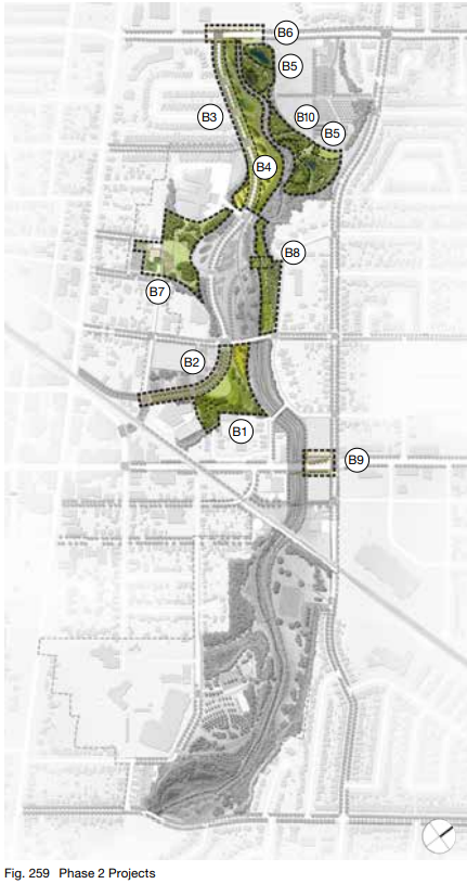
Phase 2
The projects identified in Phase 2 enhance connections within the Riverwalk and surrounding neighbourhoods and integrate parts of downtown Brampton.
Pending approval and funding, the master plan states Phase 2 projects could be implemented within a three to seven year range, depending on further coordination with other projects and developments. Detailed design is set for 2023 to 2025.
Projects include:
- the Rosalea Park Revitalization, which is planned to become the heart of the Riverwalk and a catalyst for open space improvements throughout the area. Improvements include the creation of a multi-use kiosk with event hosting capacity, public washrooms, an open sloped lawn and informal performance space with seating, new pathways and a new ramp connection to Maple Avenue from the park
- the Ken Whillans Drive extension, to allow it to become the Riverwalk’s signature street. The extension will include bike lanes, sidewalks and multi-use trails, pedestrian priority crossings, enhanced paving materials for shared use and integrated stormwater management facilities
- the reconfiguring of the northernmost portion of Ken Whillans Drive North. It will extend to complete the Riverwalk’s signature street and connection to downtown Brampton. Enhancements include new bike lanes, widened sidewalks with pedestrian priority crossings, tree planting and integrated stormwater management facilities
- the Etobicoke Creek Recreational Trail and SWM Landscapes along Ken Whillans Drive. The portion of the Etobicoke Creek Recreational Trail north of Church Street is proposed to be realigned and widened to have a closer relationship with the natural beauty of the valley and better connection to the creek. The aim is to establish the identity of the Riverwalk through its strong narrative expression and integrated stormwater management landscapes.
- the creation of new stormwater management facilities in Duggan Park to help protect the water quality of Etobicoke Creek and contribute to the overall stormwater management function of the Riverwalk area. The solution will define how the facilities will integrate with the Phase 3 Duggan Park redevelopment and other recommendations in the plan, such as improvements to the riparian edges and new boardwalks and lookouts
- Vodden Street bridge improvements, including protected bike lanes, widened sidewalks, enhanced railings and lookouts to the creek below
- the revitalization of Central Public School grounds and park, which includes the creation of a new terraced landscape with horticultural beds, new community gardens, a new fitness loop and connections to the adjacent senior’s residence, significant new tree plantings and integrated stormwater management facilities. The plan notes that the revitalization could also include the expansion of the Central Public School community centre as a green public amenity including a maintenance and operation facility and creation of integrated green roof and rainwater harvesting systems
- a new pedestrian bridge in Rosalea Park North, which aims to create new connections to Scott Street and increase the pathway network north of Church Street. The new bridge is planned to be implemented along with a new pathway connection and lookout on the east bank of the creek and would further enhance the experience of the Rosalea Park North Meadow
- the implementation of a Queen Street transit plaza at the corner of Queen and Centre Streets, which will become an important link in the City’s higher-order transit system. The creation is dependent on agreements between the City and adjacent developments. The document notes it should be considered in conjunction with the upgrades to the Queen Street bridge in order to ensure integration with the Riverwalk trail system
- a nature-based playground in Duggan Park to encourage a strong connection to nature for the park’s youngest users. The project includes nature-based play structures and equipment, integration with the site’s natural topography and interaction with the riparian edge of the creek.
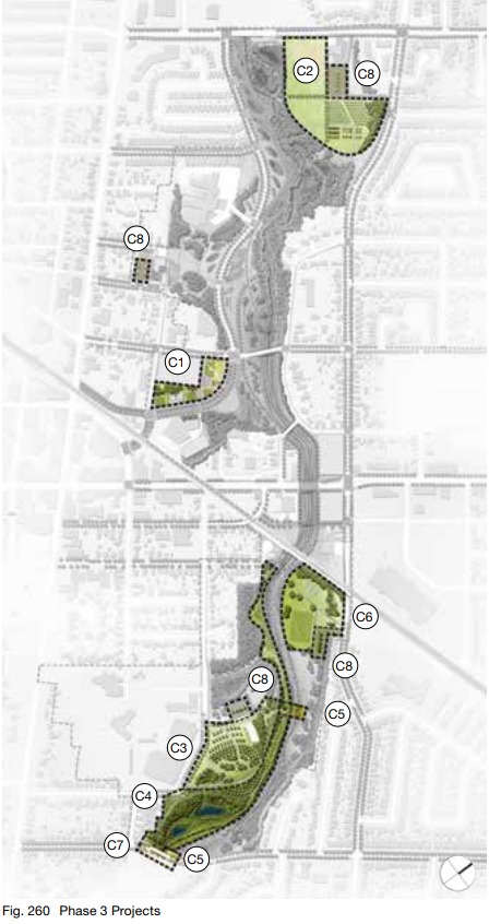
Phase 3
The Phase 3 focus is on projects that continue to elevate the Riverwalk into a showpiece within the city and promote further community and neighbourhood engagement. The projects in Phase 3 do not have established timelines and will be dependent on available funding, partnerships and City priorities.
Projects Include:
- the Rosalea Park West Plaza, which includes the creation of a new public open space with an amenity and washroom kiosk, urban water features, playground, skating loop, planting, horticultural beds and integrated stormwater management facilities
- the relocation of some of the existing sports fields from Duggan Park will allow the reallocation of open space and the creation of new, flexible park space, community gardens and potential space for urban agriculture. The removal of sports fields from Duggan Park is contingent on securing space that can accommodate larger-scale community sporting events that are currently held in the park
- the revitalization of the existing arboretum in Centennial Park. The project includes reforestation and curation of a native tree collection, realignment and creation of new trails and lookouts and the integration of stormwater management facilities
- the protection and enhancement of the existing wetland in Centennial park. It will include the creation of new wetland boardwalks, pathways and lookouts
- the creation of two new pedestrian bridges in Centennial Park to form new connections within the park, allowing pedestrians to remain within the area rather than rerouting to adjacent streets; providing new connections from the parking lots to either side of the creek
- the reconfiguration of sports fields at the north end of Centennial park to provide new flexible open space, potential reconfiguration of the tennis courts, existing children’s playground, soccer fields and the creation of a signature entrance landscape along Centre Street
- Clarence Street Bridge improvements. This is expected to include protected bike lanes, widened sidewalks, enhanced railings and lookouts to the creek below
- sustainability improvements to the existing parking lots in the Riverwalk area. Timelines are not determined but the inclusion of trees, bioretention and permeable pavements are being considered to replace the current parking lot surfaces.
Email: [email protected]
Twitter: @JessicaRDurling
COVID-19 is impacting all Canadians. At a time when vital public information is needed by everyone, The Pointer has taken down our paywall on all stories relating to the pandemic and those of public interest to ensure every resident of Brampton and Mississauga has access to the facts. For those who are able, we encourage you to consider a subscription. This will help us report on important public interest issues the community needs to know about now more than ever. You can register for a 30-day free trial HERE. Thereafter, The Pointer will charge $10 a month and you can cancel any time right on the website. Thank you
Submit a correction about this story
