
Bradford Bypass threatens ancient Indigenous site ‘more significant than 95 percent of all historic/archaeological sites in Canada’
In October 1793, a British loyalist familiar with First Nations languages travelled the forested trade paths around Lake Simcoe and wrote in his journal:
“11th: About 9 O’clock, left our encampment, embarked and soon got out of the Lake, paddled up the River about three miles, then got into another River, and about 2 O’clock got to the landing place at the red pine fort.”
The man was former military officer and Home District Sheriff, Alexander McDonnell, who was on an expedition alongside Lieutenant Governor John Graves Simcoe—the founder of York (now Toronto) and the first lieutenant governor of Upper Canada—on their way back to the capital from Georgian Bay where they were searching out future routes to support further expansion.
McDonnell had no way of knowing his words scratched in ink on the journal pages would be used nearly 230 years later to help prove the location of what heritage experts have described as one of the most significant historical sites in Canada—The Lower Landing.
Premier Doug Ford and his PC government are rushing forward with the Bradford Bypass which threatens to destroy what remains of this profoundly significant piece of Indigenous history.
The Lower Landing tells the story of pre-Canadian times and the organized system of commerce and cultural exchange between First Nations in what we now call Southern Ontario. Historians say the site was used for millennia by Indigenous peoples as a critical junction.
What came to be known as the Toronto Carrying-Place Trail, from the Mohawk word tkaranto (meaning, “where there are trees in water” which was used to describe Lake Simcoe and Lake Ontario) linked the two bodies of water and the northern Great Lakes. The word was specifically used to describe a part of Lake Simcoe with the descriptive features that gave rise to the name, and served as a significant landmark for travellers who journeyed along the route. From Lake Ontario along the Don River; the Rouge River; and starting from the Humber River, the Toronto Carrying Place and its trails terminated around The Lower Landing area. It was a key junction that grew once dirt roads began to stitch together early Canada.
“The Road from York to the Headwaters of Lake Huron has been opened, and by these means, a very excellent Tract of Country is rendered available to future settlers,” Simcoe wrote in a letter to the British Secretary of State for the Home Department.
The area was also used during the first decades of the century as the annual location for the distribution of gifts to the First Nations communities. After the landing was used as a strategic naval depot during the War of 1812, from the middle of the 19th century onward it served as a busy docking spot where steamboats carried passengers, mail and other cargo to early settlements around Lake Simcoe.
Almost two hundred years later, plans emerged to pave across much of these lands, for cars, regardless of the thousands of years of history hidden away along the watery forested corridor.
Throughout the turbulent saga of the ill-advised highway through the Holland Marsh—an idea that has gathered dust on a shelf at Queen’s Park since the 1970s and only recently revived by Ford and his PCs—there have been a number of archaeological studies done of the spot where a bridge for the four-lane highway will cross over the east branch of the Holland River.
These studies all came to the same consensus: the area was literally covered with history.
One assessment, which analyzed only 1 percent of its entire study area, found nearly 4,000 artifacts. But researchers could not agree on one crucial point: whether this exact spot, where a future highway bridge would span the river, was the location of The Lower Landing.
A plaque installed by the Ontario Heritage Trust a few kilometres south advised viewers that the Holland’s Landing Depot stood “just north” of that significant historic site. But researchers didn't agree on where the exact location was. Evidence suggested the true location was further north of the landmark highlighted by the plaque, but those who have conducted studies for the government of Ontario couldn’t draw any conclusions about where The Lower Landing was specifically located.
“This can only be determined if the site is completely excavated,” reads a 2006 study done by New Directions Archaeology, a private firm hired to consult the Province on the early work for the Bradford Bypass. The site was instead labelled with the nondescript title of BaGv-42, designating that the area had been reviewed, even though no conclusive finding on the location of The Lower Landing was reached.
Until Premier Ford was elected in 2018, this is where things stood.
The true location of The Lower Landing remained a mystery. But that was okay. The history was safe.
The preservation of a site that was a traditional meeting place for multiple First Nations in the area over hundreds, if not thousands of years, and later used as a strategic gathering place for the British effort during the War of 1812, would not be paved over for a highway being pushed by developers aggressively lobbying to construct new houses.
Along the adjacent Holland River, building foundations, trade currency, stone tools, even weaponry—naval cannons were said to have been sunk in this section of the waterway—might remain undisturbed, packed snugly within the earth or silt-thick bottom of the river.
But now, to save this site from a government bent on development at all costs, The Lower Landing’s secrets must finally be revealed, and critical questions must be answered.
Historians and local advocates working tirelessly believe they have the answers—and the true location of The Lower Landing.
Premier Ford and Transportation Minister Caroline Mulroney have shown nothing will stand in their way to get the Bradford Bypass built.
Not the provincially significant Holland Marsh wetland that the 16-kilometre highway will bisect in one of the most destructive examples of habitat fragmentation this province has ever seen.
Not the numerous at-risk species that rely on this marshy area to feed, breed and thrive.
Not the threats to Lake Simcoe, which could effectively become a dead lake if chloride and phosphorous levels continue to increase.
Not the Province's own studies showing the Bypass will fail to solve local congestion issues the government claims is the reason for the project.
Not the numerous pieces of evidence that show how environmentally destructive the Bradford Bypass would be and how it would create significant GHG emissions, contrary to both provincial and federal carbon reduction targets.
Not even the numerous First Nations communities who have said the highway could disturb sacred burial sites—many in and around The Lower Landing.
While environmentalists and local advocates raise these concerns, the PC government proceeds with early work on the project—a gambit designed to get shovels in the ground before the June election, preventing the future cancellation of the project. Both the Liberals and NDP have promised to scrap the entire plan if elected.
Public support for the project has also gone against the ruling party—a poll of three key PC ridings in the area commissioned by Lake Simcoe Watch, shows only 29 percent of local residents support the project, 48 percent are opposed.
Yet the province moves ahead, continuing to openly mislead residents in the area about the damaging highway.
“The need for the project was identified decades ago, and today, gridlock in this region has only gotten worse,” Mulroney told a local media outlet. “The Bradford Bypass will cut through gridlock on Highway 400 and existing east-west roads, making life easier for drivers and businesses in the region.”
According to studies conducted by the Ministry of Transportation, this is not true.
Traffic volume scenarios with and without the Bypass show that traffic on Highway 400 actually gets worse by 2041. The Bypass itself will see similar congestion at that time. A clear example of induced demand, increasing traffic volumes by building more roads to maximize those volumes, a fact of highway design that has plagued Southern Ontario for decades. But the PCs refuse to listen to their own experts and the Bypass, if Ford and his developer friends get their way, will be built.

The Province’s own studies show the Bradford Bypass will not significantly alleviate congestion in the area by 2041, and traffic on Highway 400 and 404 will actually get worse.
(Images from Government of Ontario)
Now, not even one of Canada’s most significant historic sites, a place that tells the story of centuries of First Nations’ life, can stop the PCs from getting their way.
“The Lower Landing site is more significant than 95 percent of the historic and archaeological sites in Canada,” reads an internal briefing note sent to the Minister of Transportation in 2005, obtained by local advocates through a Freedom of Information request and shared with The Pointer. “However, it has not been shown that the new site is actually The Lower Landing.”
At that time, it was believed the site of The Lower Landing was approximately 2.5 kilometres south of where the Bypass was planned to run.
New evidence shared with The Pointer and collected by local residents, historians and previous land owners, create a compelling case that the proposed route of the Bradford Bypass will run directly over top The Lower Landing site.
The evidence consists of historic maps and documents, all of which suggest that previous estimates of The Lower Landing’s location were mistaken.
The proposed route of the Bradford Bypass in its current alignment looks like this:
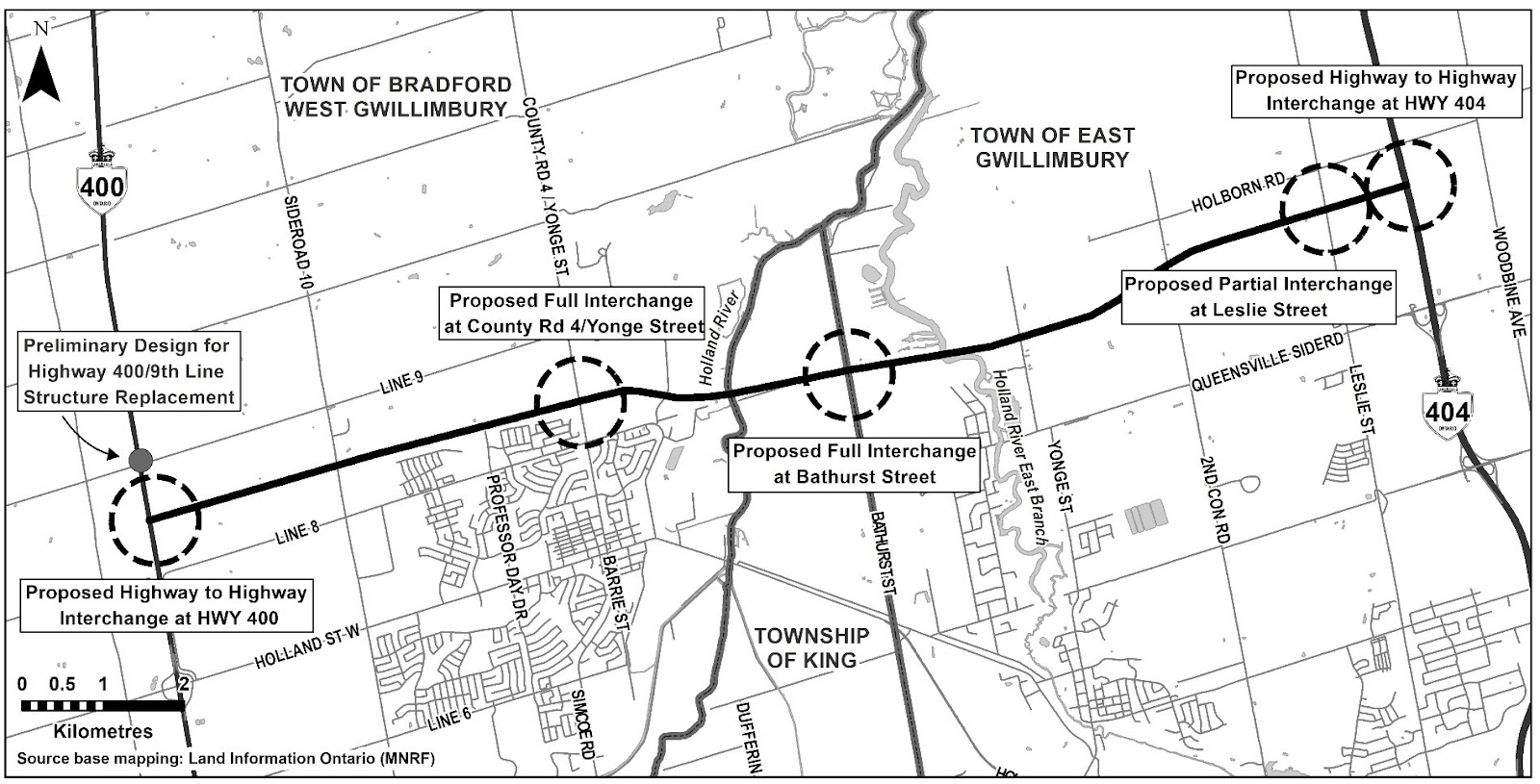
Also known as the 400-404 Link, the highway will span the distance between two of the GTA’s main north-south arteries—cutting directly through the Holland Marsh wetland complex.
The Province has promised residents that it is doing all it can to mitigate the potential environmental destruction this highway will cause.
But in October the PCs exempted the Bypass from all the requirements of the Environmental Assessment process, a system designed, under legislation, to ensure all the proper studies and potential mitigation measures are identified for a project before construction begins.
The exemption allows the government to move ahead with the project while forgoing crucial studies, including a Transportation Environmental Study Report (TESR), which would look at alternatives to driving a highway through an area that is the heart of a watershed, providing approximately $1 billion in value to the local area. Other work to ensure the preservation of areas of historic significance, protect species at risk and their habitat, and guarantee all First Nations' concerns have been comprehensively addressed, has also been missing from the PC government’s process.
The last full EA was approved almost 20 years ago.
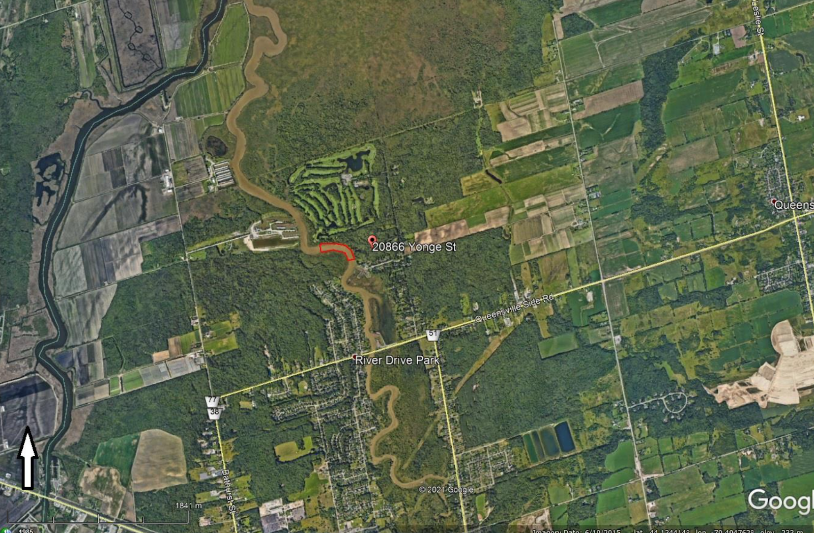
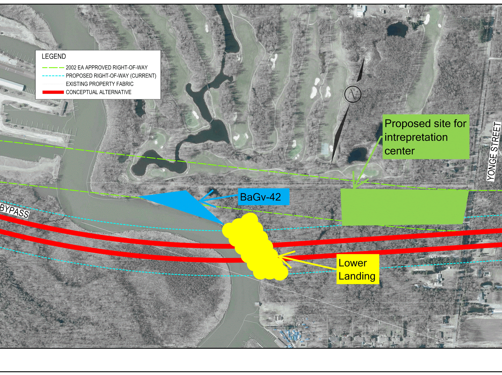
To find The Lower Landing on available maps, one must look closer. The arrow on the map below shows the approximate location where bridges will cross over the east branch of the Holland River, directly adjacent to the Silver Lakes Golf Course. The preferred route in 2002 saw the Bypass running over a corner of the golf course, but this recently changed. The owner of the Silver Lakes Golf Course is the father of PC MPP Stan Cho, the associate minister of transportation.
The Bypass alignment was reportedly changed to accommodate concerns raised by Cho’s father, regarding the impact on his golf course.
The lower map (below) provides more detail from a satellite image (the Bypass would run immediately along the golf course) and shows the impact to another property, at 20866 Yonge Street, owned by Thomas To.

The small length in red, above, has been the subject of a pair of previous archaeological assessments in connection to the Bradford Bypass, both of which discovered a significant historic site, but were not able to conclude that what was discovered was The Lower Landing. Instead, the location was simply labelled as BaGv-42.
“The East Holland River site is a large, very significant site. Given the peaks in artifact frequency, it has been occupied many times,” the 2006 report from New Directions Archaeology states.
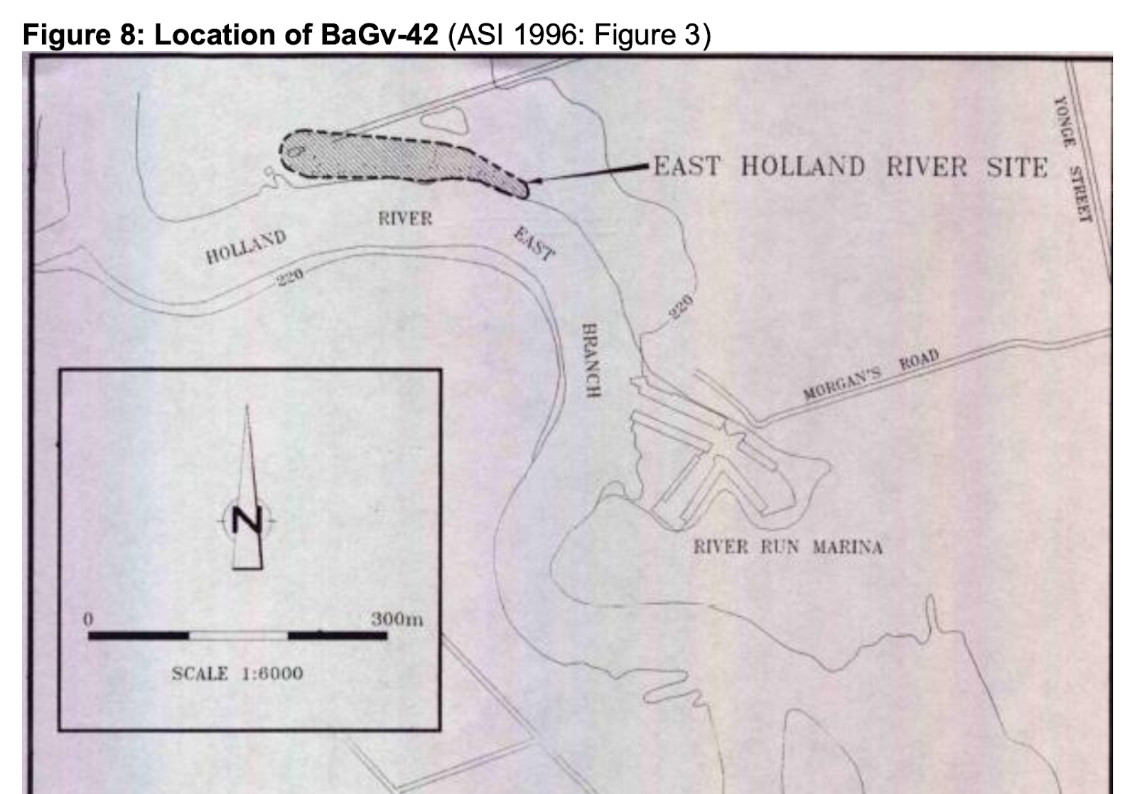
The location of site BaGv-42, which would make up the northern portion of the red area shown in the previous map.
(Image from Ontario Heritage Marine Committee)
During its study, New Directions excavated a total of 97 test squares, covering an approximate area of 60 x 220 metres—or 1 percent of the overall study area.
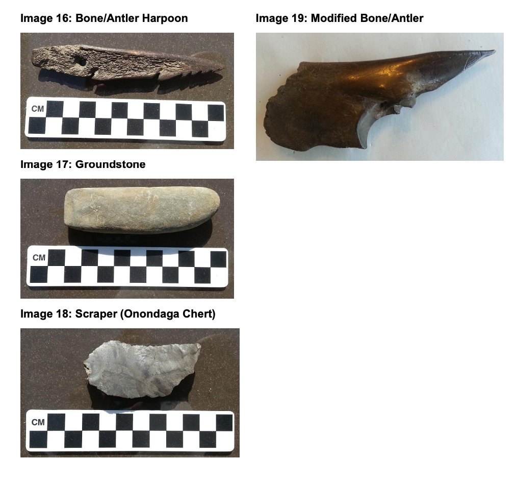
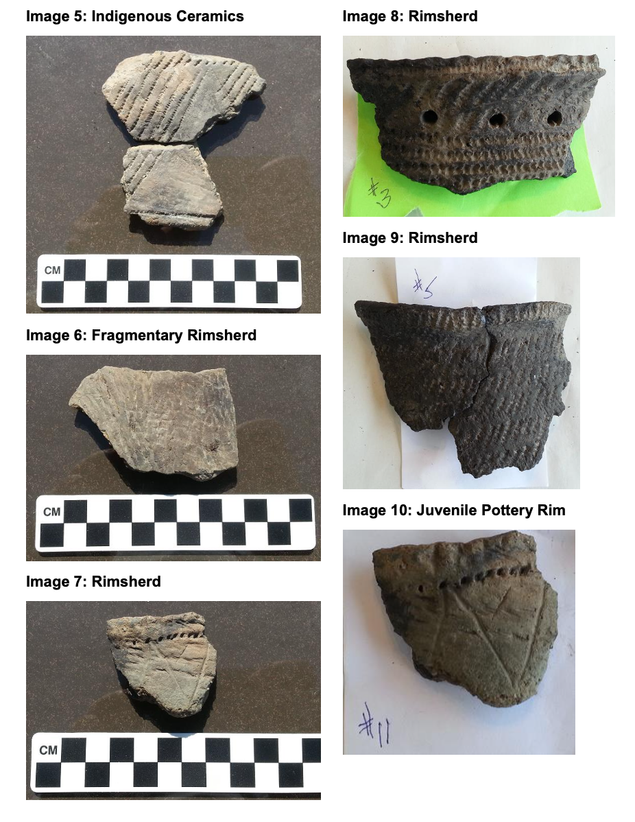
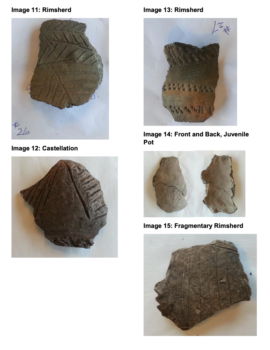
A total of 3,943 artifacts were found during this study—a “very high frequency” the report notes—including Indigenous artifacts like debitage (flakes left behind by the forming of stone tools), 13 projectile points, and thousands of ceramic sherds from historic pottery. Other artifacts found during the study include: a trade axe, cut nails, wire nails, window glass, brick fragments, buttons, and fragments of a smoking pipe.
A previous study of the area in 1996 discovered similar artifacts, including pieces of clay daub (fired clay similar to brick) and bone fragments.
“If the East Holland River site (BaGv-42) cannot be protected within the proposed bypass development plan, the site should be subject to comprehensive salvage excavation,” a 1996 report noted.
A similar recommendation was made by New Directions in 2006, urging Stage-4 mitigation, which would involve hand excavation of the top soil to avoid damaging artifacts buried in the ground.
Neither the 1996 nor 2006 study were able to conclusively state that BaGv-42 was in fact The Lower Landing, despite the volume of artifacts found at the site believed to be near the place where First Nations gathered for centuries.
A sample of the artifacts discovered at the site by previous landowners and local residents.
(Images from Ontario Marine Heritage Committee)
Archaeologist Scarlett Janusas, who runs her own Tobermory-based firm that consults on projects across Ontario, says these first two reports commissioned by the Province fell far short of what is considered an in-depth assessment, especially work that should have been done for the background research of the site.
“The first did none and the second one hardly anything, but did note that research needed to be done,” she explained. “The reports sadly fell very short of what the standards of today are and they are areas that were totally missed.”
At the time of these assessments, standards and guidelines designed to outline the scope of work involved in these types of archaeological assessments had yet to be created by the Province. These did not come into effect until 2010/2011. It means past studies of the area have not looked at crucial background documents and evidence.
The initial study also omitted 2 hectares from the study area, noting it was too wet.
“This river floods continually, so yes you’re going to get wet areas, and chances are things are buried in those areas,” Janusas says.
If past researchers had done their homework, they would have easily concluded that while BaGv-42 was not The Lower Landing—it was its next door neighbour.
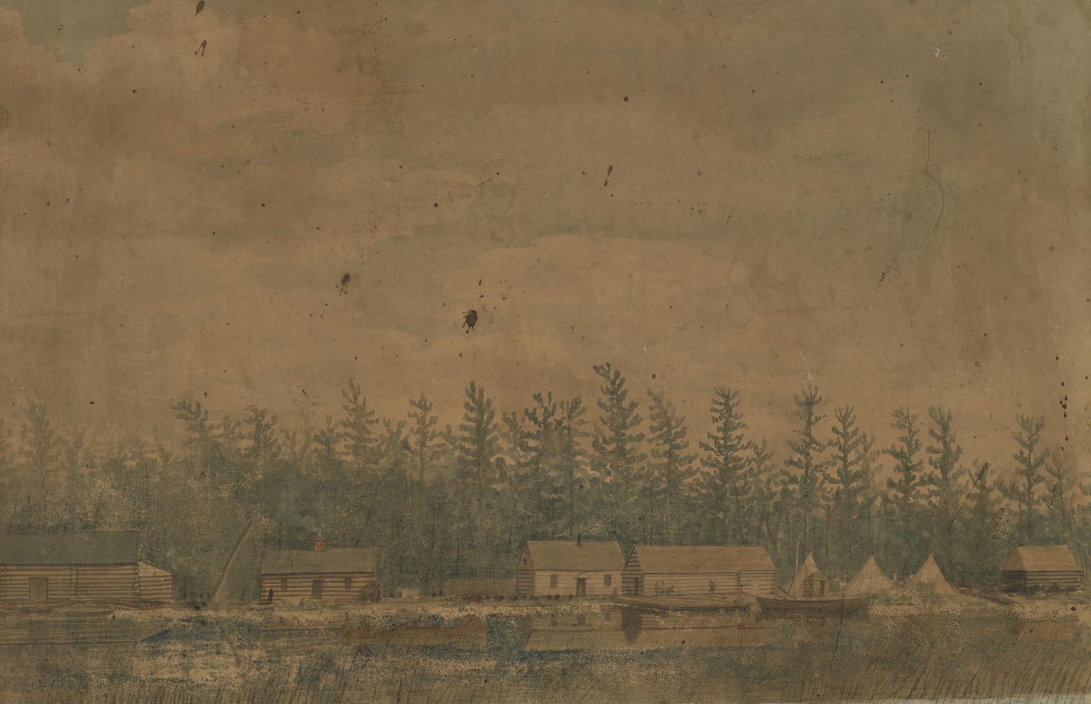
McDonnell’s journal entry from October 1793 is the earliest recorded visit to The Lower Landing, but other evidence from that time places the location in the same area of the Holland River. The location went by many other names, including Steamboat Landing, Soldier’s Landing and “old Indian Landing”.
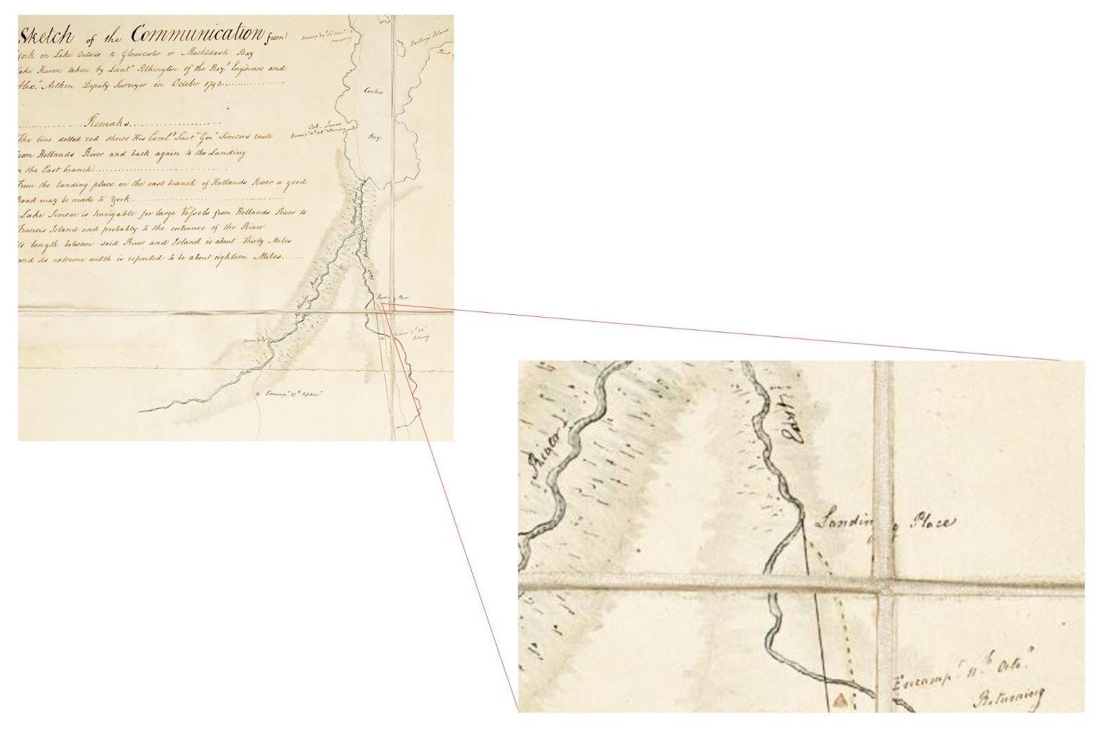
A 1793 sketch of the area notes a “Landing Place” along the meandering east branch of the Holland River.
(Image from Ontario Marine Heritage Committee)
A 1793 sketch is one of the earliest mentions of the “Landing Place” on the east branch of the Holland River. At the time, the location served many purposes, especially for Indigenous peoples. The Holland River was used as a jumping off point en route to many other locations around Lake Simcoe, and the river would have been rich with fish, waterfowl and other resources valuable to inhabitants of the area at the time.
Using historic deeds, and other hand drawn maps, it’s quite clear where The Lower Landing was located.

The map above shows the current, amended route of the Bradford Bypass where it will cross the Holland River. Where the red line hits the river is 20866 Yonge Street—or Lot 118 as it is known on property records: The land owned by Thomas To.
Historic maps identify this spot as the true location of The Lower Landing .
The first, a map drawn in 1860, overlaid with modern property lines, places The Lower Landing directly at the river’s edge on Lot 118. The second map, on which the information is illegible, places The Lower Landing in the exact same location.


(Images from Ontario Marine Heritage Committee)
“That is confirmation The Lower Landing is in this area,” Janusas says, “... it’s quite significant.”
This evidence was submitted to the Province through a report created by the Ontario Marine Heritage Committee (OMHC), of which Janusas is a member. It conducted its own survey of the area using a series of modern techniques to attempt to discern whether any heritage artifacts lie beneath the river.
The Province did not acknowledge the implications of OMHC’s findings, Janusas says.
The issue has also been raised in a series of letters sent by Margaret Prophet, the executive director of the Simcoe County Greenbelt Coalition to MPP Lisa MacLeod, the Minister of Heritage, Sport, Tourism and Culture Industries. Despite repeated attempts, Prophet has not received a response.
The Province did not respond to questions from The Pointer regarding the implications of the submitted information on The Lower Landing.
Ironically, previously proposed routes for the Bypass would have missed The Lower Landing, but in shifting the route slightly south—avoiding the BaGv-42 site—the highway is now on a collision course with one of the country’s most important historical sites, an area with incalculable significance to many of our First Nations.
The previous 2002 proposed route of the Bradford Bypass, highlighted green, was shifted recently to the one shown in red, cutting right over The Lower Landing.
(Image from Forbid Roads over Greenspace)
Even if the route was shifted further south, or back to its original route, without a full excavation of the site, Janusas says it will have significant impacts on the historical artifacts that remain in the area—which previous landowners have described as the foundations of buildings, partially submerged beneath the Holland River (which has meandered quite significantly over the years) and even naval cannons, abandoned to the elements after the conclusion of the War of 1812, which involved the British repeal of the American attacks on Upper Canada, with the help of First Nations.
“They are treating it with overwhelming disregard,” Janusas says. “The pollution is going to effect what’s in the river, the artifacts in the river. There’s an increased salt component to this. The Maskinoge River was completely destroyed in terms of salinity that was added because of a bridge that went over it.”
The Maskinoge, a tributary of Lake Simcoe, has seen a dramatic increase in salt levels since the Highway 404 extension was completed in 2014.
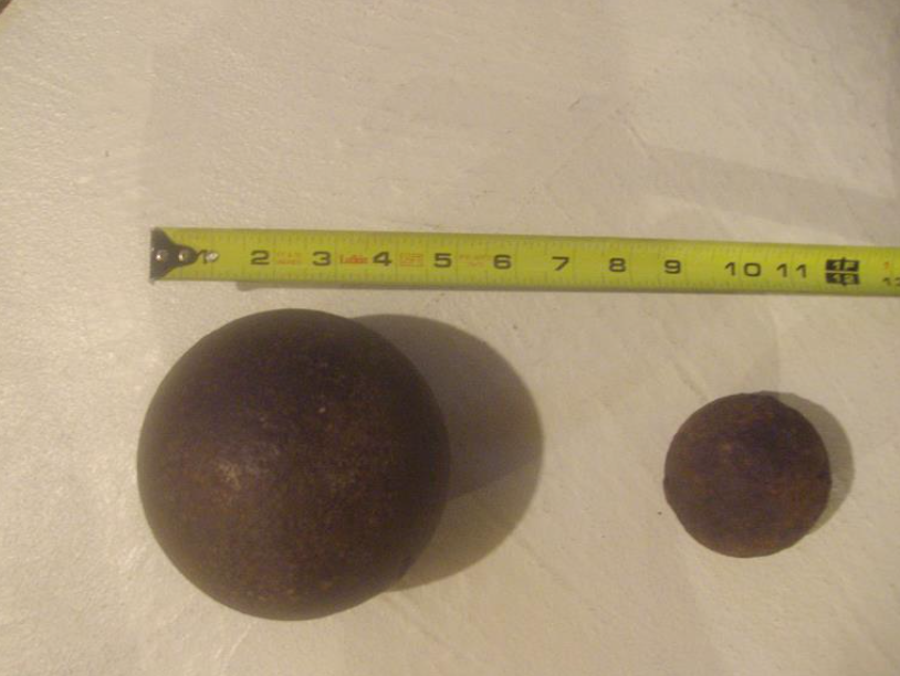
Cannonballs found at The Lower Landing site by previous landowners.
(Image from Ontario Marine Heritage Committee)
As part of its report, the OMHC relied heavily on information received from local residents and previous landowners in the area, including Willard Petersen, Dave Ladell, and Glen Penoyer (who initially contacted Janusas about studying the river area) who conducted their own archaeological studies previously. The trio removed approximately 700 artifacts from the river in 2014.
Through the use of side scan sonar (a device used to detect any rise off the bottom of the river) and magnetometers (similar to a metal detector) OMHC studied the river in the area of The Lower Landing for further evidence.
According to information from Petersen, eight or nine cannons were taken out onto the ice at the end of the war and left there to sink.
Janusas says that during the magnetometer study, 7 good hits were detected that could potentially signal the presence of several metal items at the bottom of the river.
“Could it be a cannon? Maybe, don’t know,” she says. “Probably there is something in there, what it is we don’t know because everything is buried in the sediment.”
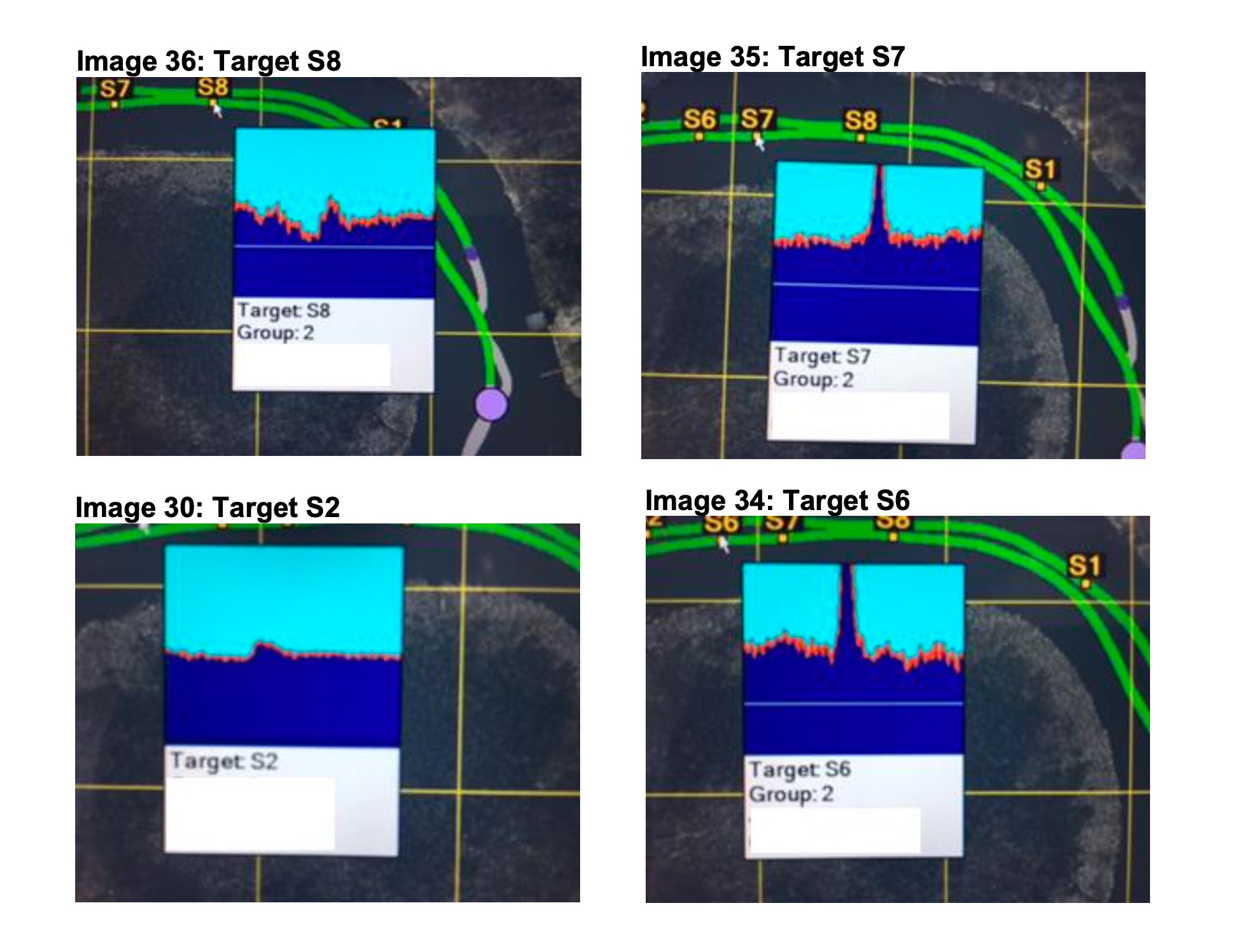
Magnetometer readings show potential metal objects resting at the bottom of the Holland River.
(Images from Ontario Marine Heritage Committee)
Janusas has met with officials responsible for the heritage elements of the Bradford Bypass study. She received no commitment from them that the Province is willing to protect the site, and was only told there is an “intent” to avoid and protect heritage elements of the area.
“Intent is a big step away from actually doing something, so I do have fears for this site,” she says.
The Province has not conducted any marine surveys of the area, which Janusas says could be used to confirm whether what her and other OMHC members detected are or are not cannons associated with The Lower Landing.
“They have told me it is not on their list of things to do at this moment,” she says.
“It is doing its damndest to bury any reference to this site because they want a highway through here,” says resident Bill Foster, whose property lies adjacent to the proposed route.
“I’m sure along the whole river stretch there is tons of history,” says To.
According to the Province’s Bradford Bypass website, archaeological assessments of the area will be completed “as required”. However, experts fear the government’s level of commitment will not be enough to protect the site.
Previous archaeological reports have indicated it would be a massive undertaking to excavate. The New Directions study completed in 2006—referring to BaGv-42, not The Lower Landing—indicated Stage-4 assessment would take years to complete.
“To provide an overall impression of how much work is involved to excavate this site, at least 8,000 one-metre squares will have to be excavated to clear this entire site. Once the site is excavated, all of the artifacts will have to be washed, catalogued, analyzed (including distribution maps), and incorporated into the final report,” the document reads. “Given the very high frequency of artifacts recovered during the Stage 3 testing, a significant number of person years would be required to complete the analysis and reporting for this site.”
With little confidence in the Province, local residents and historians are turning to the federal government and the Impact Assessment Agency of Canada, which is considering a second request to designate the project for a federal impact assessment, that could take the Bradford Bypass out from the hands of the PCs.
In May of last year, the former environment minister Jonathan Wilkinson, turned down the initial request for a federal designation, citing confidence with the provincial government’s ongoing study process to mitigate the concerns raised by environmentalists and First Nations communities.
This was before the Ontario government exempted the Bypass from requirements under the regular EA process.
The federal government has been sent the new information regarding The Lower Landing as part of the second request for designation.
“The construction of a bridge over The Lower Landing site will have a negative and permanent impact on the ability for the property to yield or have the potential to yield information that contributes to an understanding of Canada’s history, the property’s aesthetic, visual and contextual importance to Canada, as well as its association with events of important to the country,” writes Bertrand Duclos, a former heritage outreach consultant with the Ontario Ministry of Culture, to Steven Guilbeault, the current Minister of Environment and Climate Change.
Duclos says the pivotal role of The Lower Landing to the survival of the young Canadian colony during the War of 1812 is “immeasurable” due to its strategic location and access to the Great Lakes.
The decision to not designate the Bradford Bypass for an impact assessment in May of last year is one still surrounded by confusion.
At the same time, the federal government designated the Highway 413, or GTA West Highway, for an impact assessment, citing concerns to Indigenous rights and species at risk. It could result in the cancellation of the project, despite Ford’s determination to build it, making good on his promise to developers in 2018 to open up greenspaces, including the legislatively protected Greenbelt, for new home construction.
The federal government was aware of the exact same concerns with the Bradford Bypass. In letters to the Impact Assessment Agency, several First Nations communities raised serious issues around impacts the construction of the Bypass would have on their traditional territories, and the lack of effective consultation on behalf of the Province with Indigenous groups.
“As you are likely aware, the Huron-Wendat Nation (HWN) has a sacred obligation to ensure respect for and protection of our archaeological and burial sites,” Grand Chief Rémy Vincent wrote to the federal government in March 2021. “We are therefore very concerned regarding the proposed Bradford Bypass Project as it poses real risks to the integrity and protection of such sites, and, most worryingly, poses real risks to the undisturbed repose of our ancestors’ remains.”
The letter further details that the HWN has been involved in “limited consultation” with the Ministry of Transportation Ontario and has only been provided with “basic information” about the proposed project.
“We have asked MTO multiple times for confirmation that the HWN will be consulted and engaged with during any remaining archaeological fieldwork and assessments. Our requests have gone unanswered to this point,” Vincent stated, noting that the MTO has not adequately addressed all of their concerns, and there is little confidence the MTO will adequately consult with them moving forward.
“MTO consistently disregards its obligations to the HWN and ignores the HWN’s requests for meaningful consultation and involvement. That pattern has repeated itself with respect to the (Bypass) Project.”
In a separate submission, Tom Cowie, on behalf of the Hiawatha First Nation, detailed similar concerns.
“There is a high potential of archaeological sites belonging to First Nations and we also feel that there would be significant cultural heritage loss as well,” Cowie wrote to the federal government. “There is a potential destruction of burial sites as well as sacred sites. These concerns need to be discussed and consultation with all seven Williams Treaties signatories needs to take place.”
In a presentation to York Regional council earlier this month, officials from MTO noted they had consulted with the Williams Treaties First Nations, the HWN, and the Scugog First Nations, but the details of those consultations were not explained and no documentation of the First Nations’ position was shared.
Prior to the renewed push for the Bypass, concerns were raised by First Nations about the proposed route through the area of The Lower Landing.
“This site was critical and instrumental to the formation of Canada and one of the contributing factors which brought our people to take up a permanent settlement on Lake Simcoe’s south shore,” wrote Rob Porte of the Chippewas of Georgina Island in July of 1998. “It is not our intention to impede progress, however we do not want to see a significant piece of history such as this lost forever. Not only is the camp a home of our forefathers, but given the nomadic nature of the times, and the length of time this site was used, there will undoubtedly be burial ground in this area.”
Porte wrote to the Province again in December 1998.
“Georgina Island First Nation is opposed to any construction or development or development including road construction and archaeological digs at the site known as The Lower Holland Landing. We will continue to be opposed to anything that disturbs or destroys this ancient place,” he writes. “My reason not to call for a designation by Historical Sites Monuments Board is that these people may dig up this site and open it like a tourist attraction. This place must remain undisturbed. I assure you we will be opposed to this as long as it is considered an option.”
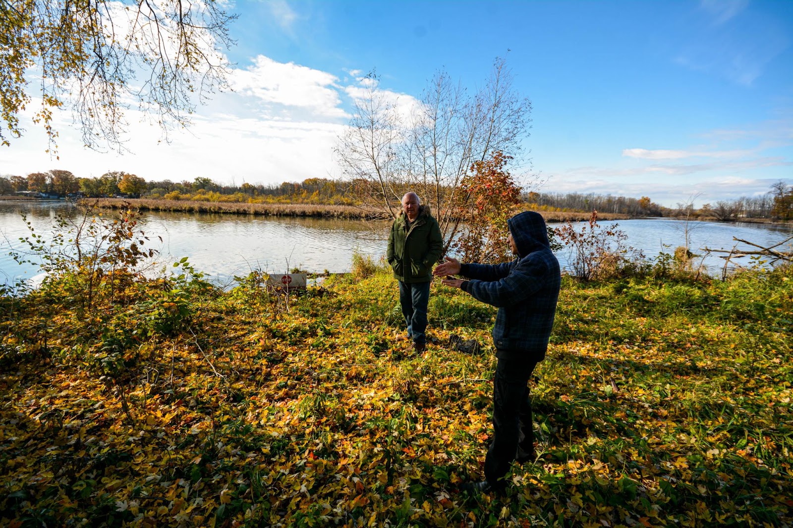
Bill Foster (left) and Thomas To standing where To’s property meets the Holland River, the historic site of The Lower Landing.
(Photo by Joel Wittnebel/The Pointer)
When asked for further clarification on its earlier decision, last year, to not designate the project for a comprehensive federal review, the Impact Assessment Agency referred back to the report released as part of the Minister’s 2021 decision.
“For its proposed Bradford Bypass Project, the Ontario Ministry of Transportation has identified ways to mitigate potential adverse effects through project design, the application of standard mitigation measures and through existing legislative mechanisms,” a spokesperson for the Impact Assessment Agency said.
It seems inexplicable that a federal process meant to ensure the protection of First Nations’ rights and history, by enforcing various pieces of relevant legislation, is instead being ignored, in the face of a massive highway development project.
When asked how this response aligns with the concerns raised by First Nations and the evidence of The Lower Landing, the Agency did not comment further.
Downplaying First Nations’ concerns contradicts previous statements made by Prime Minister Justin Trudeau as government action, or inaction, relates to the significance of Ottawa’s destructive historical relationship with Canada’s Indigenous peoples, and Trudeau’s claims of committing to turn this around.
“No relationship is more important to Canada than the relationship with Indigenous Peoples,” Trudeau wrote in a 2017 statement.
He said much the same in June to mark the first National Indigenous People’s Day.
“It is the responsibility of the Government of Canada to make significant change within our federal institutions. We must continue to review our laws and policies to see how we can improve outcomes for Indigenous peoples and for all Canadians, and rebuild or develop laws and policies accordingly in partnership with Indigenous peoples,” he said.
These words came in the weeks following the discovery of children’s bodies, hidden away and left unmarked, at the former site of a residential school in Kamloops—a horrific discovery that would be followed by several more across the country with the bodies of more than 1,000 Indigenous children discovered to date.
Trudeau and his government, instead of making good on their promises, now remain silent despite an opportunity that has been handed to them to address deep concerns being raised by First Nations communities over the Bradford Bypass.
Janusas says she was surprised Indigenous stakeholders were not invited to the meeting she attended with provincial officials—which would have given them the opportunity to see the new information that has come forward regarding The Lower Landing. Provincial officials told her a separate meeting would be held with Indigenous stakeholders.
“I was a little astounded that they hadn’t been included in the meeting,” Janusas says.

Thomas To stands on his property, the site of the historic Lower Landing. Over his right shoulder a bright orange survey marker can be seen marking the potential future path of the Bradford Bypass.
(Photo by Joel Wittnebel/The Pointer)
The lack of attention being paid to The Lower Landing by the Province has started to worry some local politicians.
East Gwillimbury council has been a strong supporter of the Bypass along with elected officials in the neighbouring municipality of Bradford West Gwillimbury (against the will of a growing number of residents) but at a council meeting in November, Councillor Terry Foster suggested it was time the town made a stronger effort to get answers surrounding how the Province plans to mitigate the potential damage to cultural heritage in the area.
“We have municipalities all around us asking very difficult questions about this highway going through the marsh and the health of Lake Simcoe… I think we better start asking some difficult questions also,” he said. “I can’t help but think that if council and senior staff read all the information that was in there about the history of the area, of The Lower Landing and the Upper Landing, and Soldier’s Bay, and senior staff for that matter, how can we not have questions about what’s going on?”
Councillor Foster suggested it was time to “light a fire” under local MPP Caroline Mulroney to get the information they need.
“Are they going to do a proper environmental assessment, are they going to look at the archeological merits of this area and if not, what are their excuses for not doing that?” He asked. “The more and more I read about this, the more concerned I become.”
“I agree with you 100 percent that we need to be talking about the important things for us that need to be dealt with,” said East Gwillimbury Mayor Virginia Hackson.
Foster went further: “I think we need to really push the fact that we understand how important the highway is, or important an east-west bypass is, but I think we need to let them know that we’re not willing hosts to just move in and start bulldozing wetland and very, very significant historical areas.”
East Gwillimbury council then passed a motion demanding the Province conduct a number of studies before proceeding with the Bypass, including archaeological assessments, and consult with all Indigenous communities who are stakeholders. The motion stopped short of rescinding support for the highway.
“The bottom line,” says Foster, “is, based on what I’ve heard, it would be my concern that some of the councillors are listening to the developers rather than the residents of the area and they have not been anxious to do anything other than refer to the Province and say ‘The Province is doing it, we trust them’.”
- The research conducted and kindly provided by Scarlett Janusas, Bertrand Duclos and local residents/historians is acknowledged in the writing of this article.
Email: [email protected]
Twitter: @JoeljWittnebel
COVID-19 is impacting all Canadians. At a time when vital public information is needed by everyone, The Pointer has taken down our paywall on all stories relating to the pandemic and those of public interest to ensure every resident of Brampton and Mississauga has access to the facts. For those who are able, we encourage you to consider a subscription. This will help us report on important public interest issues the community needs to know about now more than ever. You can register for a 30-day free trial HERE. Thereafter, The Pointer will charge $10 a month and you can cancel any time right on the website. Thank you
Submit a correction about this story
