
Mississauga flood study shows dire need for cities to prepare for climate change
“A slightly overcast day. I had dad's gardener over to trim the 12-foot hedge on the south side of the back garden. He had just finished up when the first drips began. We were still bagging up the last of the debris when the deluge began. I was inspecting the hedge from the back deck when the rain became torrential,” writes Janine Le Forestier on July 8, 2013, in her diary.
The ensuing flood caused widespread property and infrastructure damage across Mississauga, Brampton and many other parts of the GTA.
It closed roads, left people stranded on GO Transit, overwhelmed city stormwater systems and was the most costly storm in Ontario’s history, causing $932 million in damages.
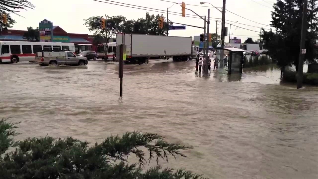
The 2013 flash storm turned parts of Mississauga into a lake. (Screen grab YouTube)
Le Forestier was one of many Mississauga residents who had their basements flooded and possessions ruined on that soupy summer day. As her Lakeview home was inundated by rain she rushed to the basement to see the damage done by just a few minutes of torrential rain.
It came down from the sky in walls, like a waterfall.
Immediately, about two inches of water had poured in from the door leading outside. She called her children and a furious all hands on deck effort to divert the water from her already damaged basement, and piano began.
For the next two weeks, Le Forestier dealt with the overwhelmed insurance companies as she began the difficult rebuilding process. It took six months to repair the damage to the carpet, walls and tiles caused by the afternoon flash flood.
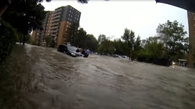
Janine Le Forestier's backyard in 2013. (Screen grab Janine Le Forestier)
On this unexpected day, rain poured from two storm systems (pictured above), causing chaos across the sprawling GTA. A report by Amec Environment & Infrastructure Inc. notes a Toronto Region Conservation Authority (TRCA) water gauge near Toronto Pearson Airport observed 138 mm of rain in about 10 hours. According to climate data between 1981 and 2010 form the Toronto Pearson weather station, the area sees approximately 681 mm of rain annually. It means the 2013 storm dumped about a fifth of the province’s yearly rainfall in a single afternoon.
As the effects of climate change continue to worsen, these types of massive storms, which bring colossal flooding, are predicted to become more common.
The heaviest amount of rain fell during a two-hour period from the beginning of the storm at around 4:30 p.m. to 6:30. The maximum rainfall in one hour was 79 mm. The federal government’s criteria for defining “Heavy Downpour” in Ontario is 50 mm or more within one hour, which triggers a widespread warning through Environment Canada.
Since the 2013 flood in Mississauga, the municipality has poured a lot of resources into its stormwater management system. Recently, Mississauga City Council approved a $520,000 expansion on the environmental assessment (EA) of Little Etobicoke Creek.
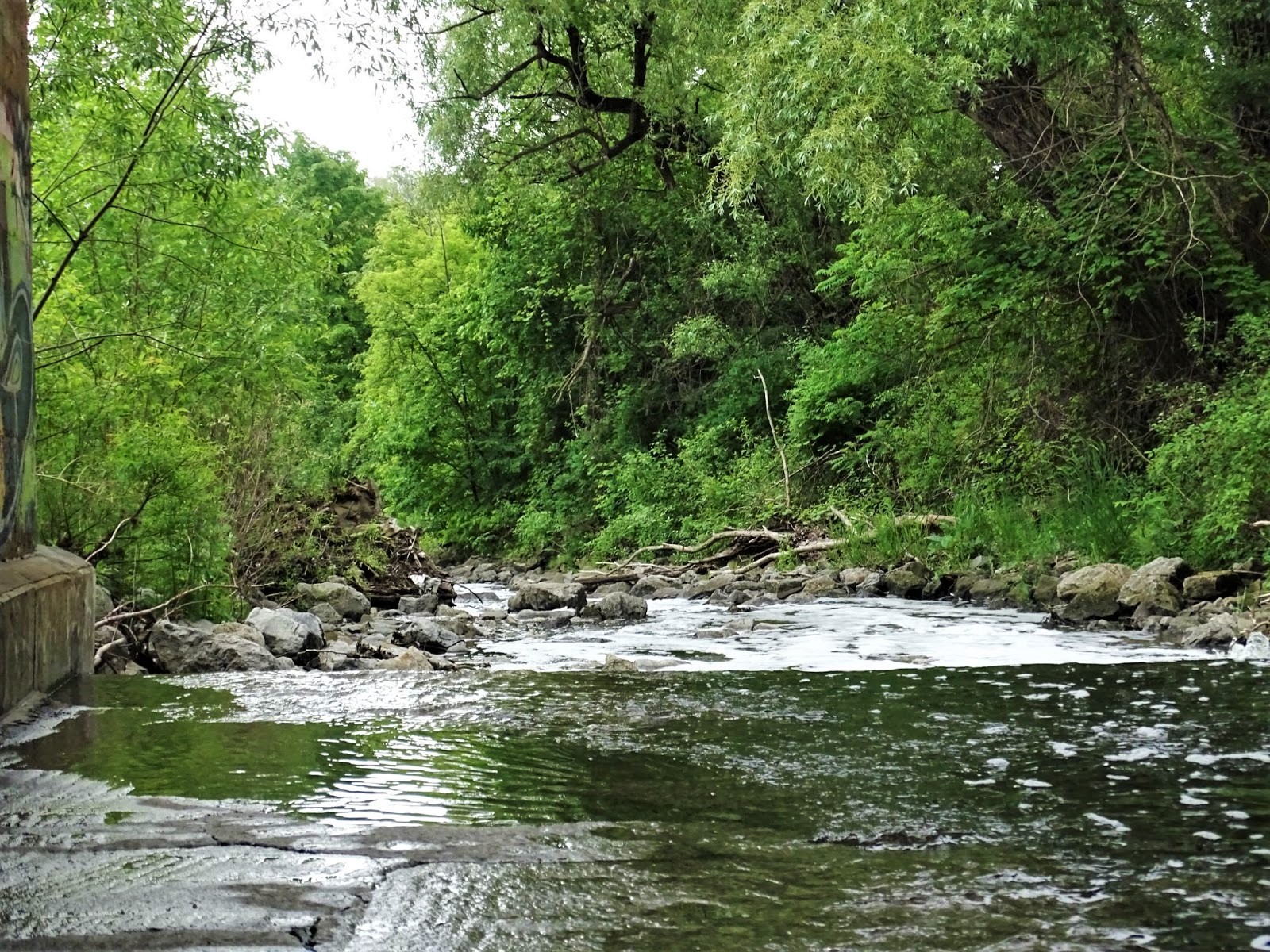
Little Etobicoke Creek right underneath the Canadian Pacific rail tracks, approximately 550 metres downstream of Dundas Street. (Photo: The Pointer - Natasha O’Neill)
Matrix Solutions Inc. the company in charge of the assessment, needs more funding to use advanced technologies to find solutions for the high water levels and flooding potential in the area of Dixie and Dundas.
In an effort to protect the homes and businesses in the area, Matrix was hired in 2019 to conduct the EA to study past flooding that has occurred from the creek and find potential solutions. This project will allow council to make future development decisions while keeping in mind the floodplain and required mitigation.
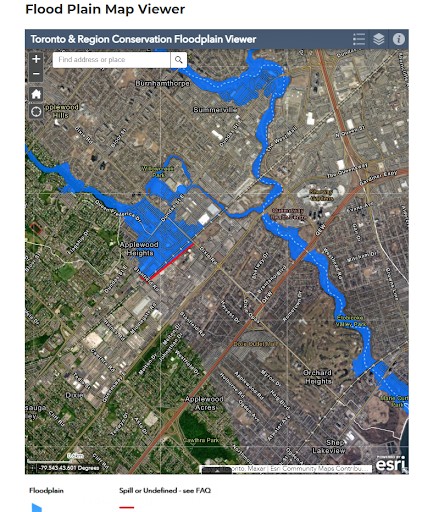
The Toronto Region Conservation Authority covers this area of Mississauga. It has extensive floodplain mapping on its website. (Screen grab: TRCA flood mapping)
The Dundas Connects Master Plan is one development the City hopes to protect with the flood mitigation study. Dundas Street is a critical roadway in the heart of Mississauga holding various businesses and homes. With the population growth expected, the recommendations are to develop more transit and bike lanes along the road, and create more spaces for complete communities.
Providing a proper EA of the area will help the city protect its plans for Dundas Connects and mitigate risk from any future heavy rainfalls. The broader study area will include 550 metres downstream of Dundas Street and can provide mapping for the Canadian Pacific rail crossing.
“Given the complexity of the flooding issues, additional analysis above the originally planned works would be required to ensure adequate and full consideration of project impacts,” the City staff report states.
Through prior study of the area, Matrix identified where the creek crosses Dundas Street as a clear area of focus. The study expansion includes hydraulic modeling, technical studies and selecting a solution for flood mitigation in the area. The company will also be doing erosion assessments and providing detailed designs and solutions for the issues found.
Mississauga’s highly intricate drainage system of storm sewer pipes spreads over 1,911 kilometres; if laid out end to end it would reach Winnipeg. This doesn’t include the 270 kilometres of ditches, 150 kilometres of creeks and 52,000 catch basins, all dedicated to collecting and draining rainwater runoff before going to Lake Ontario.
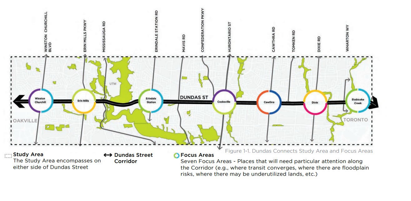
The Dundas Connects Master Plan ties into the environmental assessment being done around Little Etobicoke Creek. (City of Mississauga Dundas Connects plan)
In 2020 the entire system value was estimated at over $4.8 billion, and is one of the largest assets owned by the City. Maintaining and continuing to update the stormwater plan is a priority. In the 2021 to 2024 stormwater business plan, the City budgets repairs of infrastructure, flood mitigation studies, design of erosion restoration projects and specific work to provide flood relief to the Dixie-Dundas neighbourhood.
Over the next few years the City expects the stormwater capital investments to increase to $48.6 million by 2024.
By last year, a number of projects were completed and started protecting high-risk flood areas. The Lisgar community received a pump station to assist with the basement water intrusions they were dealing with. Construction at Sandalwood Park began for a series of underground storage galleries, which can hold and process water, while designs for two other facilities started.
Cooksville Creek, which runs from the city’s southeast corridor to Rathburn Road, was further protected from rising water levels with the completion of a stormwater pond at Saigon Park. It can hold 240-million litres of water and is now one of the largest in the province.
The pond played a key role in 2019 when 20,000 litres of diesel seeped into it from Highway 401, which otherwise would have travelled downstream via Cooksville Creek to Lake Ontario. The creek also saw the completion of two construction projects to restore erosion through Woodington Green Park and near the Mississauga Valley Community Centre.
Despite the millions of dollars towards stormwater diversion the City is left vulnerable because of its topography and make up. Mississauga, and its Credit River watershed, sit in the middle of a basin that runs from northern headwaters across the Greenbelt down toward Lake Ontario. Think of it as being in the middle of a bathtub that can fill up very quickly when the water faucet is turned on.
Senior climatologist at Environment Canada, David Phillips, told The Pointer, flood mitigation and climate change starts with one individual and one house.
“I think it begins in the neighborhood. I think it begins in the individuals, it doesn't begin city-wide. It begins with giving incentives to people to weatherproof their home,” he said.
With the sprawling infrastructure Mississauga and other parts of the GTA host, more concrete, which does not allow water to absorb into the ground, will leave the City vulnerable to floods as climate change sees increased events of heavy water fall. Phillips explained rain falling on a grassy knoll will take eight hours to reach the water table, on a parking lot it takes eight minutes.
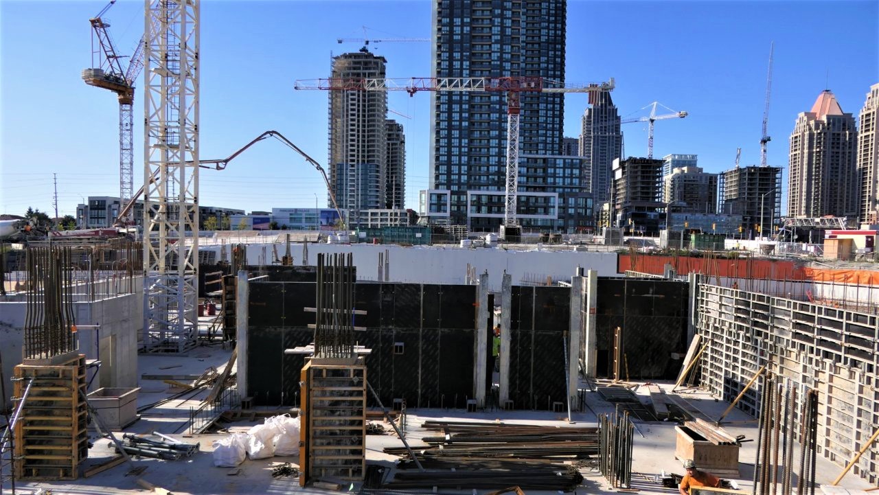
Concrete construction is booming in Mississauga (The Pointer file photo)
“We go from green infrastructure to grey, we turn them into parking lots and strip malls and cloverleafs on highways. We think that's progress. Well, it may be progress and maybe good for tax bases, but it is leaving yourself more vulnerable to heavy storms when they do occur,” Phillips said.
The stormwater charge costs taxpayers $110 per billing unit, with money going back into the repairs and construction of new storm diversion projects. Rahul Mehta, a local environmentalist and program worker for the Mississauga Cycles Project, recalls a large back and forth between incentivising homeowners to be flood prepared.
“Residents very broadly, and I guess increasingly, have been frustrated that the City has incentivized businesses to reduce stormwater leaving their site but not homeowners. That was a point of contention with the stormwater charge where there's no incentive,” he told The Pointer.
Mehta was a part of the consultation process on the current stormwater management plan and hopes other solutions like downspout disconnections and rain barrels will continue to be implemented. Homeowners are not incentivized to obtain these water mitigation tools for their property, because of the push for the large stormwater management infrastrastructure the City has.
Mehta said his street in Erin Mills constantly sees backups due to the sewer system in summer and winter because of debris that clogs up the system.
“It’s almost like I expect it to happen,” he said.
Other ideas including making all flat top buildings have green roofs in the City would be beneficial to soak up water in the event of a large rainfall.
After Le Forestier’s basement flooded she wanted to rip up her concrete driveway and add gravel so any water could drain into the ground. She was told at a neighbourhood meeting this was illegal.
The Pointer reached out to the City and it confirmed there is a bylaw in place that states driveways are to be, “designed to be structurally stable while allowing rainwater infiltration and may include pervious pavers and paving or interlock, but shall not include landscaping elements such as gravel, dirt or limestone screening.”
The alterations humans have made to the environment is not something that can be undone, but something to change for the future. Currently, 20 percent of Mississauga’s surface is dedicated to right-of-way roads which is the second largest land use in the entire municipality.
Rehana Rajabali, associate director of engineering services with TRCA, told The Pointer prior to knowledge on floodplains and watersheds, cities would often build in these areas to expand growth. To build further on a floodplain, cities need Special Policy Area (SPA) approval from the Province. Much of Brampton’s city centre is in an SPA due to the proximity to Etobicoke Creek, which causes major flooding in the area.
The downtown core was created entirely in a flood prone area and now the City will have to spend tens of millions to mitigate the risk.
Similar to Mississauga’s Dixie-Dundas area, Etobicoke Creek is the challenge as well. Brampton’s Riverwalk project will hopefully mitigate the risk of further flooding by widening and deepening the creek channel, but the City has not yet funded the plan.
“And then Hurricane Hazel [1954] happened. And we learned that nature is powerful. And it changed the way we looked at flood risk management,” Rajabali said.
Hurricane Hazel turned much of Southern Ontario into a lake. Hazel was the deadliest natural disaster in Ontario’s history, killing 81 people.
Mehta’s 55 gallon rainwater barrel is often close to overflowing because of regular summer storms. The water used to be collected to water his garden, but with the increased amount of precipitation he’s had to drain it.
“One of the most traumatizing things is now, in the middle of heavy and dangerous thunderstorms, I have to run outside,” said Mehta.
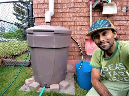
Rahul Mehta has been catching water in his rain barrel and diverting it away from his basement. (Photo submitted by Rahul Mehta)
Natural disasters and heavier than normal storms are becoming more frequent in our world due to climate change. Between 2017 and 2023, 33 radar sites across the country will be finished, in hopes of staying on top of impending disasters.
“We say that we get one day more accurate every 10 years. So for example, what has changed in terms of our forecasts from that 2013 flood is that the seven-day forecast is now as accurate as the six day forecast was 10 years ago,” said Phillips.
As severe weather events occur more frequently, added surface coverage for urban infrastructure and even private properties might make for a perfect storm in Mississauga, where City officials are now scrambling to mitigate a problem that has been entirely man made.
Email: [email protected]
Twitter: taasha__15
COVID-19 is impacting all Canadians. At a time when vital public information is needed by everyone, The Pointer has taken down our paywall on all stories relating to the pandemic and those of public interest to ensure every resident of Brampton and Mississauga has access to the facts. For those who are able, we encourage you to consider a subscription. This will help us report on important public interest issues the community needs to know about now more than ever. You can register for a 30-day free trial HERE. Thereafter, The Pointer will charge $10 a month and you can cancel any time right on the website. Thank you.
Submit a correction about this story
