
Ottawa pledges $38M to fix Brampton’s downtown flood threat but City needs to find money for its share
Leaders at City Hall want to transform Brampton’s downtown core into a place filled with jobs, bustling businesses and teeming foot traffic, mimicking development seen in large cities across North America.
The historic city centre, often called the Four Corners and once a jewel in the GTA, began to show signs of decay in the ‘70s. The risk of a massive flood, after downtown was swamped by a once-in-a-century storm in 1948, slowed down the forward momentum of the area. A few decades later, commercial developments such as Shoppers World to the south and Bramalea City Centre to the east drained the Four Corners and storefronts were boarded up, one by one.
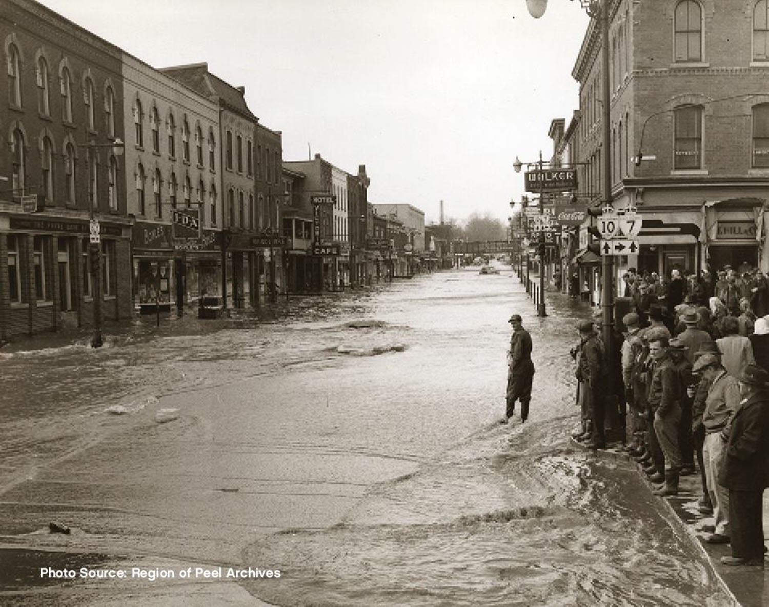
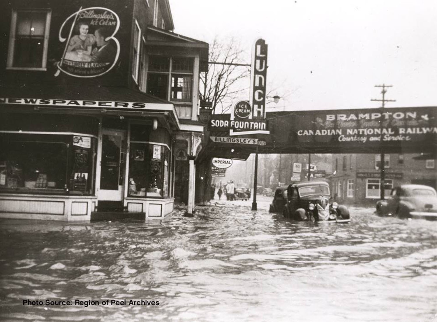
A 1948 flood that submerged downtown Brampton revealed the dangers of developing in a floodplain. Without a solution, growth in the city centre has been slowed for decades.
Now, there are still businesses dotted around City Hall, and the Rose Theatre stands ready to welcome guests, but downtown Brampton shows all the signs of a neglected neighbourhood.
A Special Policy Area (SPA) designation by the Province means it is difficult to develop in the area because of strict controls over zoning and approvals for construction, due to the risk of flooding throughout much of the city centre.
The area is in a floodplain and Etobicoke Creek, which runs along the spine of the city, threatens to spill over its banks if another severe storm event strikes.
Climate change has elevated the risk and the frequency of major storms.
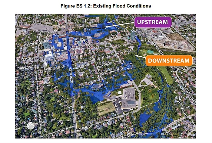
Several areas throughout downtown Brampton face a risk of flooding. Expensive infrastructure improvements are needed in order to mitigate the risk.
To remove the shackles that have locked out future downtown growth, the City needs to mitigate the flood risk and have the SPA restriction lifted.
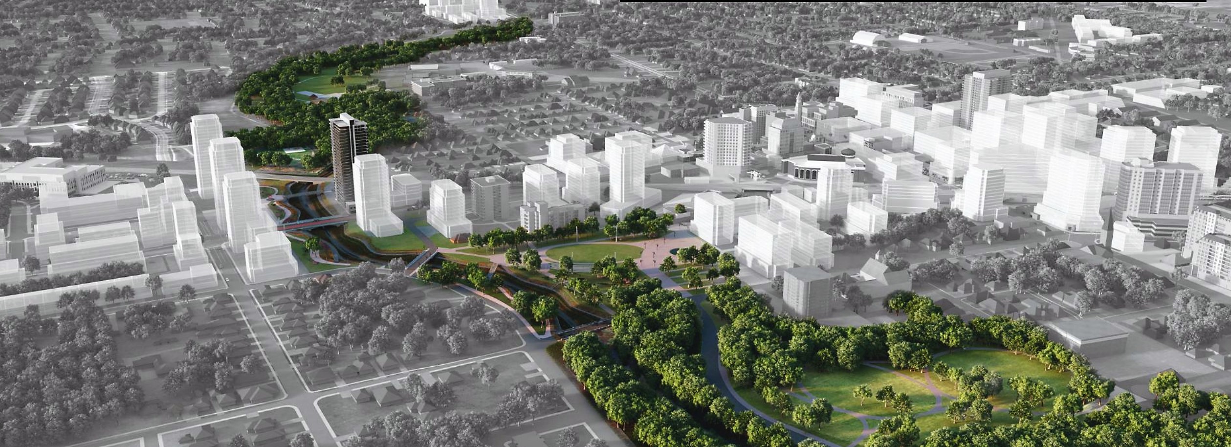
The idea is to build a wide channel for Etobicoke Creek that can handle even a colossal weather event. At the same time, if done right, it could attract huge development and reinvent the city’s fading city centre.
This dream is represented in the City’s Riverwalk project and will be detailed in the Riverwalk Area Urban Design Master Plan, a new document that is currently being developed by the City.
Other plans and outlines have come and gone, while businesses that have been loyally waiting for a strategy are now dealing with the added pressure of a pandemic. The downtown core has suffered throughout the years; decaying infrastructure has created another layer of headaches for downtown business owners.
In an attempt to find a solution to all the barriers, the City of Brampton, in partnership with the Toronto and Region Conservation Authority (TRCA) has been examining ways to protect the downtown area from flooding, and get the SPA lifted.
After years of analyzing its floodplain, the City is now one step closer to making this a reality.
In September, the Ontario Ministry of Environment, Conservation, and Parks approved the revised environmental assessment (EA) that was submitted by the TRCA back in June. This allows 19 of the 31 hectares currently under SPA to possibly be removed from the restrictive designation if the design, which will soon be worked out, reflects the needs of the area outlined in the EA. It details the movement of bridges and roads and the technical design work is estimated to take two years to complete. Construction, if funding is lined up and there are no significant unforeseen obstacles, could begin in 2023, lasting between 3 and 5 years.
The EA outlines two geological realities that impact the downtown floodplain. The first details that when a flood occurs, water rises through the valley area, a lower portion of the broader city centre-area where Etobicoke Creek runs, and flows through downtown. A flood from a large storm would impact the valley area and spillover into parts of downtown.
The second issue is “narrow valley conditions” near Centennial Park that cause water to back up, increasing the flood level, and creating the risk of the downtown core being flooded in a major storm event.
The solution to ease these problems means creating more room in the by-pass channel located between Church Street and the Canadian National (CN) rail bridge so stormwater can be contained. The plan calls for widening parts of the channel to 50 metres.
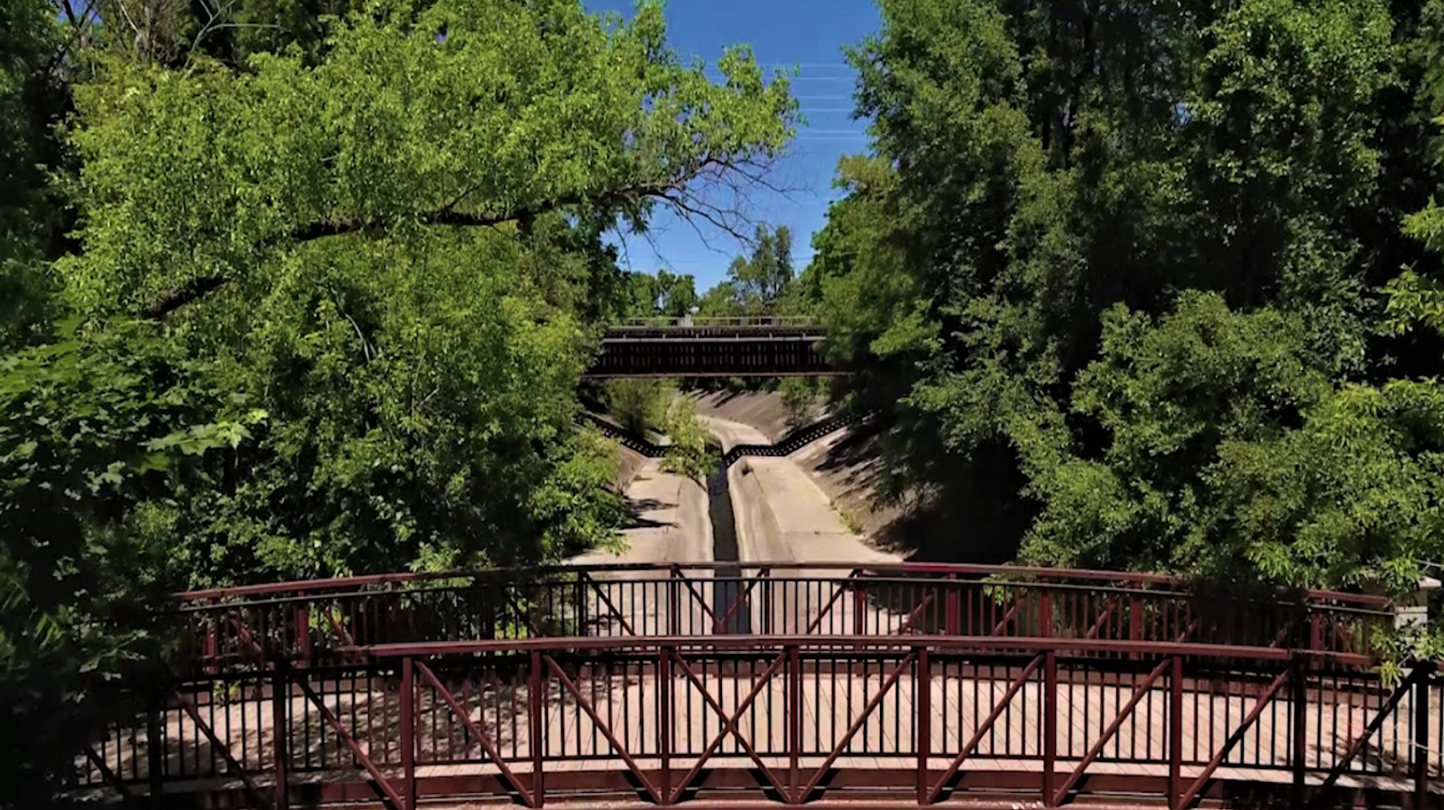
Mitigating downtown Brampton's flood risk will require widening the existing bypass channel.
In order to implement this, the by-pass channel will need to be widened by 10 metres and deepened by about 1.2 metres. This step asks the City to acquire four residential properties, one commercial property and a nearby woodlot to have enough space to make the widening happen.
Ken Whillans Drive will have to be realigned 100 metres west and raised between 0.5 and 1 metre. This option was chosen as it allows for more opportunities to create a pedestrian friendly street, while also allowing for additional design options through the Riverwalk area.
The goal, like other cities around the world, is to turn the waterway into a major attraction for commercial, recreational and residential development.
The Church Street Bridge, Scott Street Bridge, and Queen Street Bridge will be replaced to accommodate the changes outlined in the EA. Businesses on these streets will be impacted, as storm sewers, electrical cables, and a water main along Ken Whillans drive will need to be relocated.

A significant task for the Riverwalk project will be the realigning of Ken Whillans Drive to accommodate the infrastructure improvements.
The EA also states the CN rail bridge will need to be modified as well, but it’s not clear if the City or CN will be responsible for the cost. A similar level of uncertainty existed when a draft of the EA was released to the public back in February.
The EA process cost $3 million, with $1.5 million coming from Ottawa, about $1.2 million from the City of Brampton and $300,000 from Peel Region through federal funding.
Designing and building the project has a much larger price tag, with estimates putting the cost between $86 and $106 million. There will be a better understanding of the final cost after the design process is completed. The process will involve numerous considerations, such as the impact of disturbing areas of archaeological or historical importance, including unmarked grave sites at St. Mary’s Roman Catholic Cemetery.
On Wednesday, Minister of Infrastructure and Communities, Catherine McKenna, announced the federal government will invest about $38 million in the project through the Disaster Mitigation and Adaptation Fund.
A spokesperson from Infrastructure Canada confirmed to The Pointer the new funding is in addition to the $1.5 million the federal government provided in 2018.
The application, which the City acknowledged was being made earlier this year, was not the first time it asked for financial assistance. In 2018, an expression of interest (EOI) was submitted for $105 million for the Riverwalk project. Brampton’s request was rejected, and Ottawa cited high demand for projects starting in 2019 and 2020 as the reason for its decision.
Now, Ottawa is pledging roughly a third of the capital funding.
“This project, I know, is a critical component to a long term climate change mitigation strategy that the City is embarking on,” McKenna said. “We need to keep the community safe from increasingly violent storms that overwhelm municipal drainage and cause flooding.”
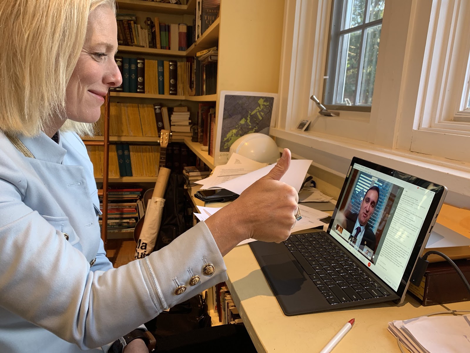
Minister of Infrastructure and Communities, Catherine McKenna, speaks with members of Brampton city council.
The City itself is responsible for funding the remaining cost, unless the Province steps up with assistance. It’s unclear how the City will pay for this and it’s not known if it plans to apply for further assistance from the federal or provincial government.
Megan Ball, a spokesperson for the City, told The Pointer funding will come through the budget. “The foundation of Riverwalk is the Downtown Brampton Flood Protection Project, and prior to beginning the design process, staff will bring a report to Council for funding allocation through budget amendments for the City’s portion.”
It’s unclear if future budget plans to accommodate the tens of millions needed for the Riverwalk project will come from property tax increases, debt financing (which would require revenue from taxes or user fees to service it) or other potential revenue sources.
In the 2021 budget, only 4 million is allocated through the 2022 and 2023 capital budget to fund the planning process of the Downtown Brampton Flood Plan and the Riverwalk Urban Master Plan.
The City may choose the option to finance the project through debt, as it has the capacity to borrow up to $1.32 billion. But it’s unclear how a council, which has approved two consecutive tax freezes pushed by Mayor Patrick Brown, will feel about this in the future.
Email: [email protected]
Twitter: @nida_zafar
Tel: 416 890-7643
COVID-19 is impacting all Canadians. At a time when vital public information is needed by everyone, The Pointer has taken down our paywall on all stories relating to the pandemic and those of public interest to ensure every resident of Brampton and Mississauga has access to the facts. For those who are able, we encourage you to consider a subscription. This will help us report on important public interest issues the community needs to know about now more than ever. You can register for a 30-day free trial HERE. Thereafter, The Pointer will charge $10 a month and you can cancel any time right on the website. Thank you.
Submit a correction about this story
