
New report on Brampton’s LRT extension study leaves more questions than answers; is the City putting the cart before the horse?
For people in the working world, commuting is often the worst part of the job.
Most Brampton residents, employed in Mississauga or Toronto, among other cities, know this all too well. Though transit use in Brampton is increasing at rapid rates, with ridership in 2018 growing by 14 percent from the previous year, commuting is still a major issue in a community experiencing explosive population growth.
Making the lives of local residents easier drew the inspiration for the Hurontario-Main LRT. But that dream was dashed in 2015 when the previous council rejected the province’s approved alignment and now the route moving forward, with 19 stops and an 18-kilometer track already into the early construction phase, will stop at Steeles Avenue. It will connect Brampton to Mississauga and the Milton/ Lakeshore West GO Train Line.
But in Brampton, the want is to build the line further into the city, like the original plan called for, extending the LRT into the downtown core, and maybe even beyond, in the future.
After months of silence on the progress of the project to get light rail into the heart of the city, new information has emerged.
But the lack of updated financial details for options being evaluated, how the LRT can operate within the provincially designated Etobicoke Creek downtown floodplain and whether or not the length of Main Street being examined can even accommodate a high order rail system, in the absence of any completed technical/geological and surface grade assessments, along with many other unanswered issues out of the new report, beg the question: what exactly has the City been doing on the LRT file?
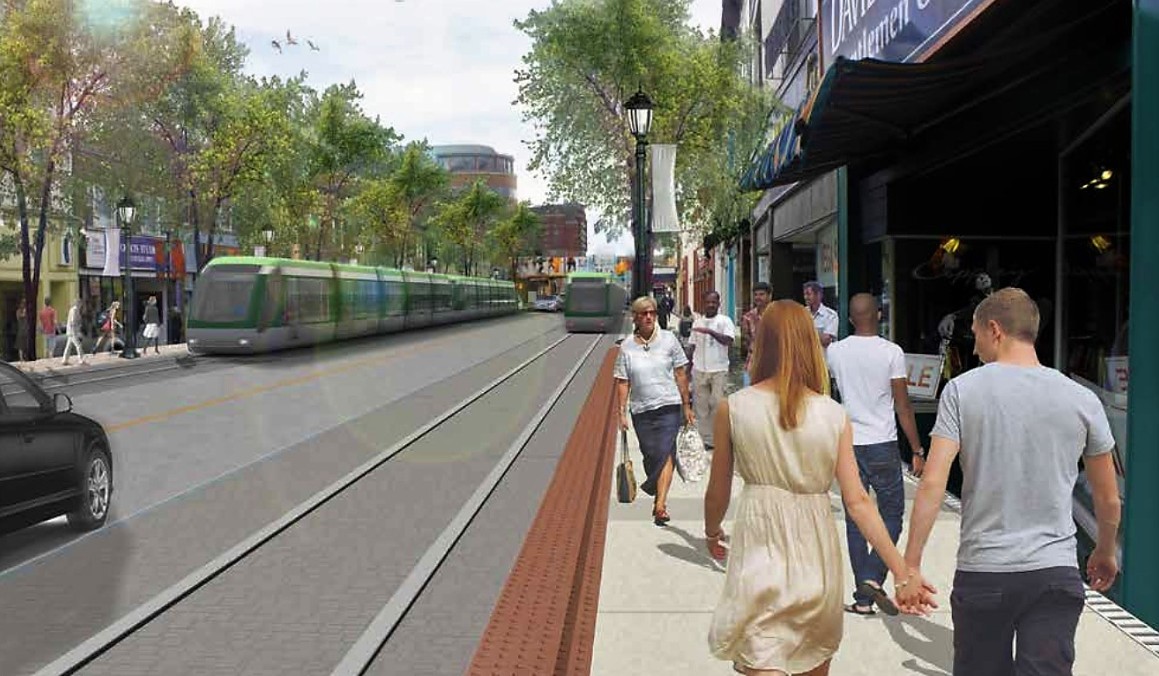
The LRT shown running just south of downtown Brampton
A brief history of the political machinations surrounding the LRT offers some needed context.
Under the previous Liberal government a Transit Project Assessment Process (TPAP) was conducted under provincial transit agency Metrolinx. Such a process only offers a limited scope of understanding and does not include technical variables that only a full environmental assessment can properly examine. The EA is currently ongoing and is expected to be completed around the summer of 2021, but with the ongoing pandemic and other delays it could easily run into 2022.
The previous council rejected the province’s Main Street alignment under its limited TPAP process, citing floodplain issues, the lack of surrounding growth potential because of Special Policy Area restrictions (related to the flood risk), unanswered questions about how even a fraction of an LRT’s ridership capacity could be reached for the entire Main Street length and concerns of disrupting the character of the downtown heritage district.
Former mayor Linda Jeffrey rejected these views and pushed forward with the province’s plan, but she was defeated and the Main Street option was scrapped in favour of either a Kennedy Road or McLaughlin Road north-south option in and out of downtown.
But after the 2018 election and Mayor Patrick Brown’s victory, the pro-Jeffrey faction on council grew and they immediately scrapped Kennedy and McLaughlin, putting Main Street back on the table.
Brown, who had been supported by those councillors that fought against Main Street, as well as former premier Bill Davis, who owns a heritage house along the historic route and also rejected the alignment, came up with another option: to tunnel the LRT under Main.
It remains unclear where he got the idea or if he or any of his staff did any research into the feasibility of a tunnel through a floodplain, but that’s what the City is now trying to figure out.
There still has never been a full, completed environmental study, no proper ridership analysis and no clear resolution to the downtown floodplain issue. Main Street runs right through this high-risk area.
One other problem: between $300 million and $400 million for the Brampton length of the project that the province had committed, was taken off the table when its TPAP alignment was defeated.
The whole project currently has not one cent of funding, other than money for the ongoing EA, and won’t qualify for any until the assessment is completed.
Another confounding reality: TRCA, the local conservation authority, which just issued its own updated downtown Brampton floodplain environmental assessment effective June 4, doesn’t want to touch the Main Street LRT issue.
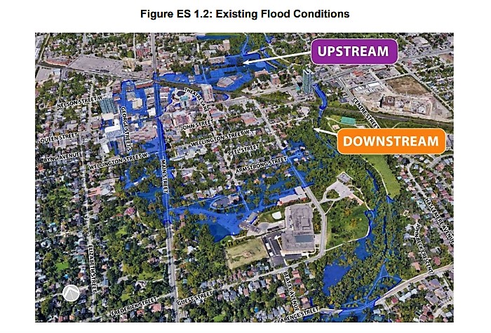
TRCA's downtown floodplain map with an illustration of where the greatest risks are, including right along the Main St. LRT route
The TRCA EA report states: “The LRT is not the focus of the Downtown Brampton Floodplain Project.” It says the City of Brampton is doing its own EA for the LRT and it is completely separate from TRCA’s work to determine how to solve ongoing problems with the city’s floodplain.
TRCA’s EA report says construction in the downtown area continues to be heavily restricted by the Special Policy Area designation because of the existing flood risk.
“There exits a risk to life and property due to flooding [in the area] at depths reaching up to three metres,” TRCA states.
This includes the area where the proposed Main Street LRT would run through.
It’s unclear why the TRCA (which would normally be working directly with the City) with its serious concerns about any construction in the area, is not involved in the LRT EA process.
It states in its brand new EA report on the floodplain that Brampton will not be able to realize its transit or other growth plans for the downtown until it builds proper flood mitigation infrastructure.
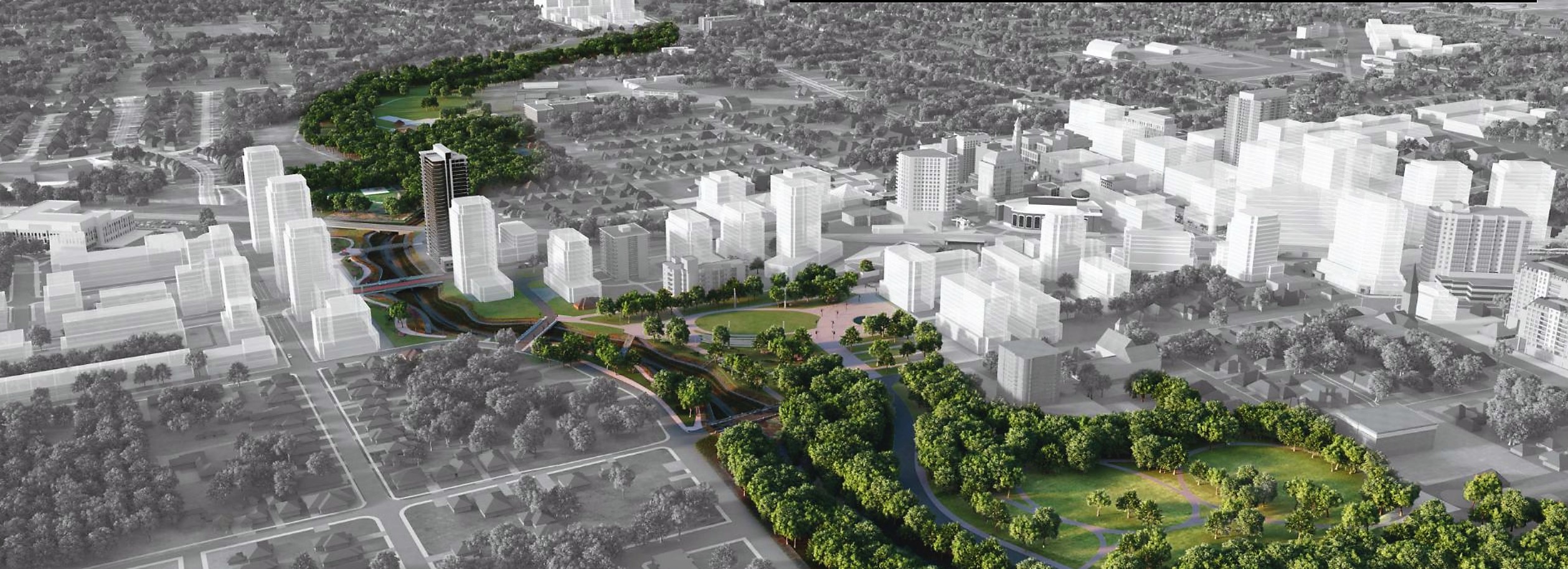
The proposed Riverwalk downtown flood mitigation corridor
Estimates for this, according to The Pointer’s sources, are between $100 million and $300 million dollars. The City is currently looking at its Riverwalk plan to build this water-diversion corridor, but no meaningful update has been provided for about a year.
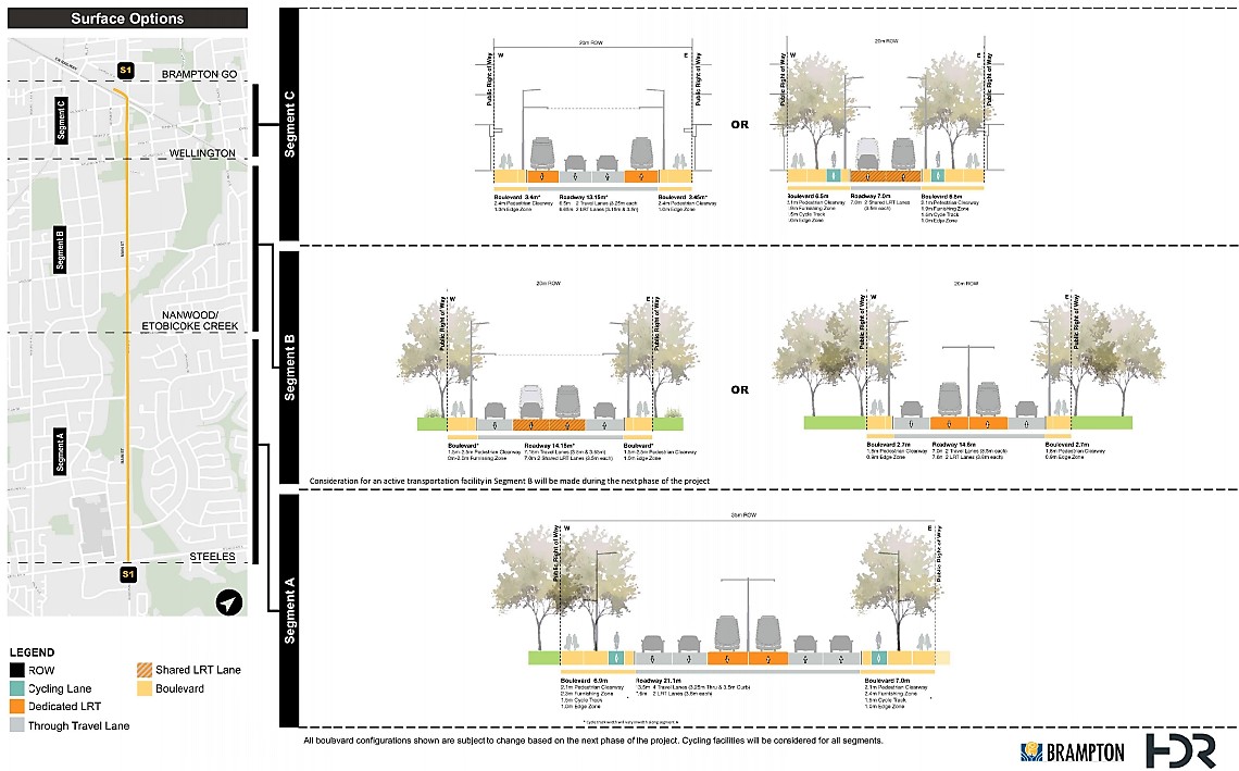
Meanwhile, the new LRT report by the City of Brampton focuses on the surface option, the loop option, or the underground option.
The report highlights three segments that could be developed along Main Street if the extension is approved. The street is divided into three sections with options for alignment focusing on existing right of way, lane width configuration and adjacent land use.
Kuman Ranjan, the author of the report who works under the public works and engineering department, explained to The Pointer the goal is to find the best way to get people from point A to B to C. Each of these segments will be examined through the lens of which proposed route option works best in segment A, B, and C: the surface option, the loop option or the underground option.
The Surface options
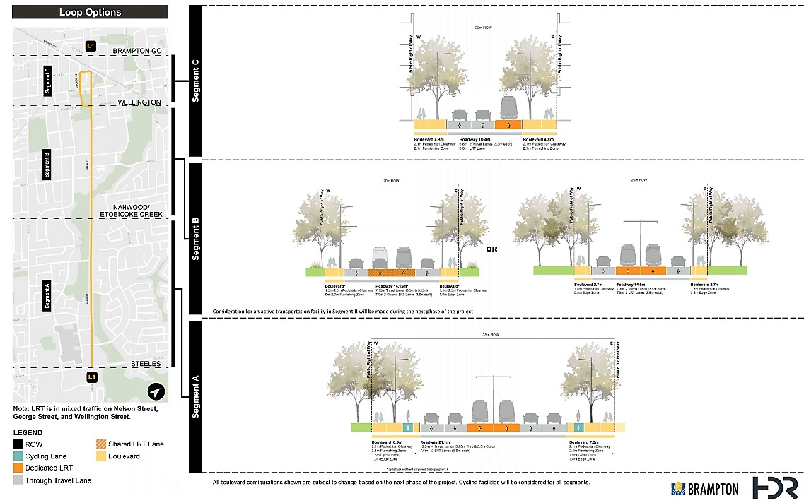
The Loop options
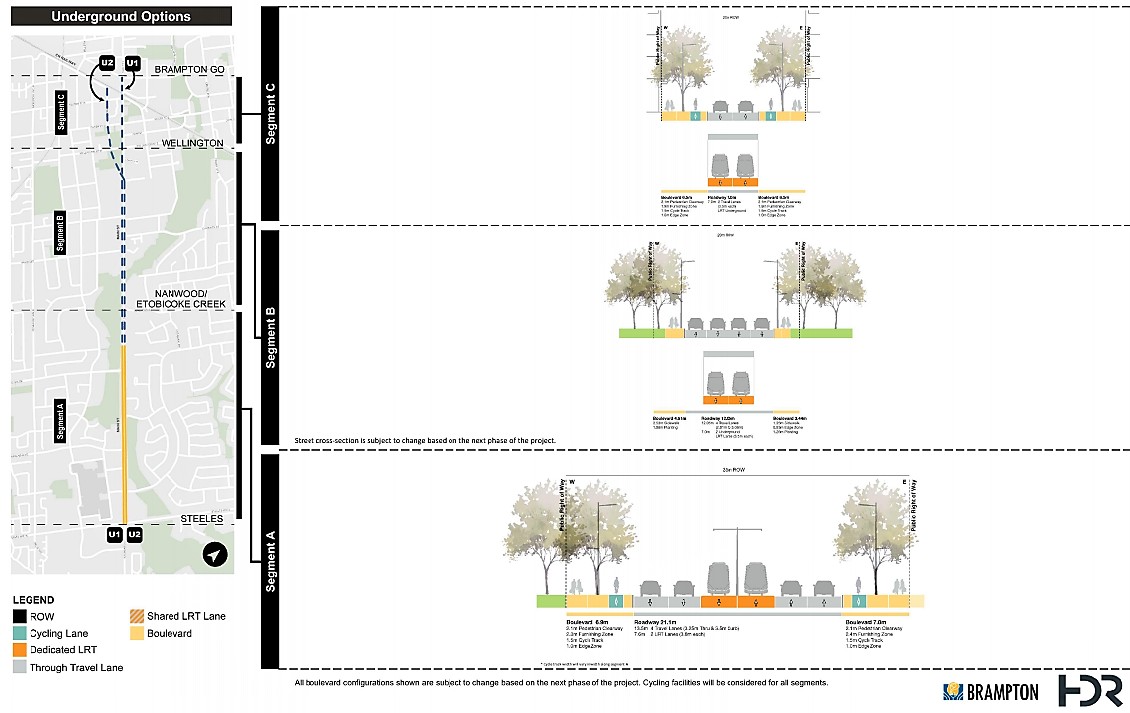
The Underground options
The report states these three segments were decided on after narrowing them down from a longer list of options using the evaluation criteria Metrolinx uses for preliminary design business case studies. Factors include economic benefits for Brampton, the capital cost for each option and the process for how each would be constructed and delivered.
While capital cost is something that was considered to shorten the list of options, the report does not share what each of the options presented would cost.
“Cost evaluations will be completed once the short list of options ha[s] been finalized,” City spokesperson Natalie Stogdill told The Pointer.
Following a virtual public consultation scheduled later this month and another later in the year, Stogdill said, “At the end of the EA process, a report with the final options will be considered by Council. We are currently scheduled to complete the EA in late Summer 2021.”
Staff, in the meantime are preparing to take the current report and its information to their first virtual consultation on June 22 to get input from the public and stakeholders.
It is not clear why no costing details for the options are currently available.
Previous reports have stated the original surface option would cost approximately $400 million, the loop option $450 million and the tunnel option as much as $1.7 billion. It’s not clear how these figures were calculated or if the numbers have changed.
Segment A runs from Steeles Avenue to Nanwood Drive/Etobicoke Creek and has the widest right of way, 35 metres, out of all three segments. It includes an approximate seven meters on each side of the road to be used as a boulevard. This includes a cycling track and sidewalks for pedestrians to walk on. The roadway is 21.1 metres, with 13.5 metres to be used as four lanes of traffic and 7.6 metres to be used for two LRT lanes. Future studies will examine which of the three alignment options (surface, loop and underground) work best with this segment.
Segment B is set to run between Nanwood Drive/ Etobicoke Creek and Wellington Street. For the loop and surface routes, this involves two options to choose from, one with slightly more space for travel lanes and the other providing more space for the LRT.
For the underground option, the segment presents a different picture, given routes above ground will not work. For the underground option, segment B involves 4.5 metres for the boulevard, 12 metres for four lanes of traffic, and seven metres for two underground LRT lanes.
Segment C runs between Wellington Street to the Brampton GO station. Under the surface options, the choices lie between allowing cars to be part of the route or allocating the space for a larger boulevard. Segment C for the underground option provides approximately the same amount of space for the boulevard, travel lanes and LRT.
Just as the report lacks details on finances, it also lacked discussion from council. The report was not presented by any member of staff and no members of council asked questions specific to information in the report.
The only question that came was from Regional Councillor Paul Vicente (Wards 1 and 5) on an update pertaining to the Hurontario LRT and how discussion on moving a stop for the Brampton Gateway Terminal to North of Steeles was going.
Alex Milojevic, the general manager for transit, said while staff have been working with the province and Metrolinx on the issue, the efforts have yet to yield a final decision. “[Staff] don't have any traction,” on the topic, Milojevic shared at the committee of council meeting.
That was not the answer Mayor Brown was looking for, remaining adamant that moving the stop on the Mississauga LRT line now under construction is something the province will consider.
Brown proposed a successful committee motion (which needs to be ratified at full Council) for staff to continue to look at the design for the LRT stop North of Steeles and directly contradicted Milojevic’s words. “We're making a lot of progress with the Premier's office and Metrolinx on having the stop on the North side of the street,” he claimed, without providing specific details about how this was happening. “I believe the province is going to let us do this. I'm optimistic about that,” he added soon after. He has not explained if the City would have to pay to cover the move, how much that might cost or how it would be paid for.
Clear answers were also missing after a delegation addressed a big discrepancy between the proposed loop option. Fight Gridlock in Brampton, a resident group advocating for active transit, said the loop option shown in the June 3 report was not the same one presented in the last report on the matter, listed as May 15, 2019 on the City’s website, and reports prior.
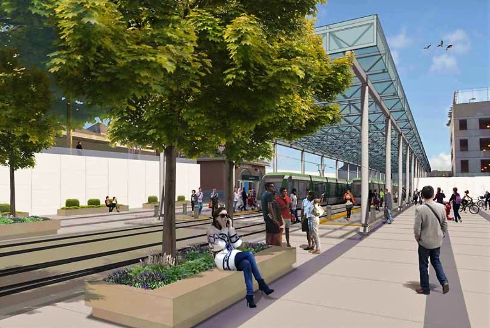
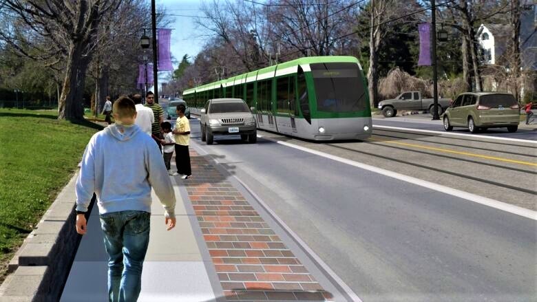
A rendering of the LRT near the downtown GO Station
These reports show the route running between Wellington Street and the Brampton Go Station. “Option #2 is a one-way loop at-grade that travels northbound on Main Street, connects to the Brampton GO station, and travels southbound on George Street and eastbound on Wellington Street West before travelling further southbound on Main Street,” the 2019 report states.
The June 3 report shows the loop option not reaching Brampton Go station and instead looping back at Nelson Street West. “Why has the George Street Loop route changed and has this been documented anywhere,” the delegation asked. Milojevic did not respond directly to the question, stating instead the comment will be incorporated in the June 22 public consultation.
In an outline to the province prior to the release of the provincial budget in January, the city asked for $1.7 billion in funding from the federal and provincial government to fund the LRT extension, with no commitments on the matter yet. The provincial budget, which was set to be released March 25, was postponed due to the spread of the novel coronavirus. Ontario’s Finance Minister shared the budget will be delivered before November 15. It remains unclear how the City could ask either Queen’s Park or Ottawa for any funding when it has no idea what the project could look like. Typically, a completed EA and technical cost specification is needed before a City can apply for infrastructure project funding.
Currently, Brampton doesn’t even know if it wants a multi-billion tunnel option or a surface route at less than a third of the cost.
And the issue of whether it can even build in a floodplain has yet to be resolved.
The current City report states a detailed update will be presented to council prior to the second open house, set to take place in the fall.
Email: [email protected]
Twitter: @nida_zafar
Tel: 416 890-7643
Submit a correction about this story
