
Vital plan to unlock downtown Brampton’s hidden jewel and fix flood problem gets funding from Ottawa
The federal government is pouring $1.5 million into a critical environmental assessment that could trigger a renaissance of development and revitalization in Brampton’s struggling downtown core, while opening up the potential of a stunningly scenic green space hidden along Etobicoke Creek.
Earlier this month, Ralph Goodale, the minister of public safety, announced the investment through the government’s National Disaster Mitigation program. The fund was established in 2015 to deal directly with the rising risks associated with flooding and for funding projects in Canadian cities aimed at improving flood protection.
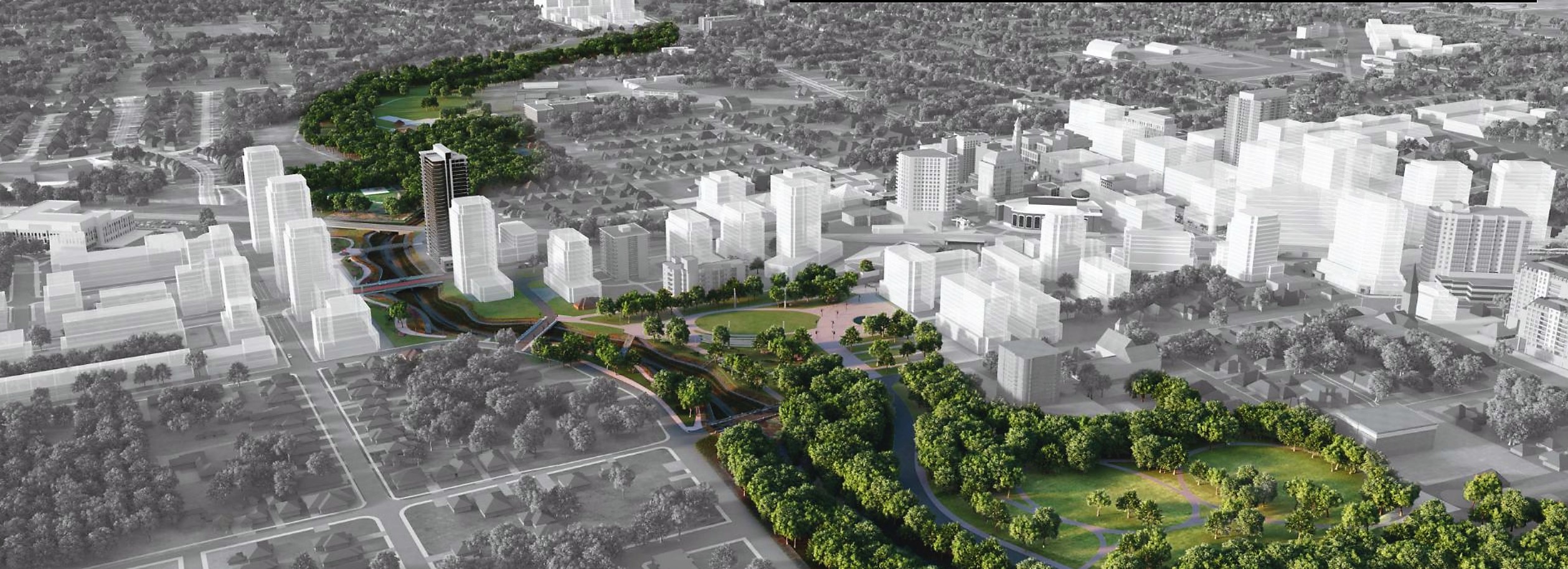
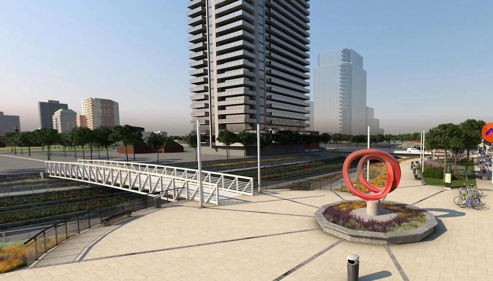
The EA is a critical step toward launching work on the city’s Riverwalk project, which aims to turn the area surrounding Etobicoke Creek near downtown Brampton into a destination spot with walking paths, possible commercial features such as dining, condos and other amenities along the winding waterway surrounded by an urban park. The work will mitigate flooding risks in the downtown, providing the solutions needed to remove a special land-use designation imposed by the province that has prevented any significant development in the city centre.

“It’s a key to unlocking the potential for residential development, along with other mixed uses in the downtown area,” says Ward 1 Councillor Paul Vicente, who sees the announcement as an indication that other levels of government are starting to take Brampton’s needs seriously. “It’s a signal that the federal government has recognized the need the City of Brampton has to mitigate the flood risk that exists in the downtown.”

Downtown Councillor Paul Vicente
“Weather-related natural disasters are getting more severe, more frequent, more damaging and more expensive. This is a threat not only to the safety of our city, but to our economic stability,” Brampton MP Ruby Sahota said in a release announcing the federal investment. “Through this funding, the Government of Canada is determined to reduce the impacts of flooding from the Etobicoke Creek and build a safer and more resilient Brampton.”
According to numbers from the Insurance Bureau of Canada, damage from natural disasters hit record levels in 2016, surpassing $4.9 billion and smashing the previous record of $3.2 billion, set in 2013. The economic costs of natural disasters have increased five-fold since the 1980s and are expected to continue rising as climate change increases the frequency and severity of storms.
The government says flood damage accounts for 80 percent of federal disaster assistance payments over the past 20 years.
The Riverwalk EA comes with a price tag of $3 million. With the feds covering $1.5 million, the remainder is made up of $1.2 million from the City of Brampton and $300,000 from the Region of Peel. However, Peel taxpayers may be off the hook for their chunk of the money, as it appears the $300,000 may come out of a multimillion-dollar federal investment in water and wastewater projects in the region announced in 2017.
The federal funds are the result of a successful application by the Toronto and Region Conservation Authority (TRCA), which owns the existing concrete channel that diverts Etobicoke Creek away from downtown. The funding marks a significant step forward for a Brampton project that has seen stops and starts for the better part of a decade.
While all parties involved have been trying to get on the same page to solve the flooding problem, the downtown area has withered under the “special policy area” designation it garnered because of its historical tendency to flood, particularly in a 1948 disaster that left most of downtown under water.
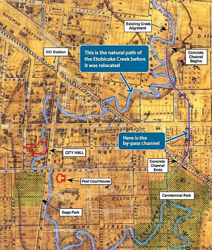
This policy area covers a large horseshoe-shaped swath that arcs through the downtown core, following the historic path of Etobicoke Creek before the bypass channel was constructed in 1952. While Etobicoke Creek was diverted, the special designation remains. It allows for only limited development to occur within the area.
To lift the designation and open the figurative floodgates to development, the city, in partnership with the TRCA, needs to construct additional flood mitigation measures in what is historically a floodplain area.
The channel was built as a flood mitigation measure, but under provincial standards it wouldn’t be enough to deal with a benchmark-level storm, what is technically referred to as a “regulatory storm event.”
A “regulatory storm event” is based on rainfall data collected from the worst storm in Southern Ontario history; all potential flood mitigation measures are compared with those numbers to make sure they can withstand the worst of the worst.
In this case, the worst of the worst was Hurricane Hazel, which struck Southern Ontario in October 1954. The devastating storm, which killed hundreds and wreaked havoc across the United States before hitting Canada, killed 81 people in Ontario, mostly in Toronto, and caused approximately $100 million in damage.
At its peak, the storm dropped 8.4 inches (214 mm) of rainfall, more than three times the amount of rain all of Ontario sees in an average month. However, these numbers fall shy of those anticipated in the “regulatory storm event.”
Hazel struck in 1954, two years after Brampton’s downtown bypass for Etobicoke Creek was completed, and the bypass was able to contain the rain dumped on it. However, the storm wasn’t centred over the Etobicoke Creek watershed.
To eliminate the designation of “special policy area” downtown, Brampton needs to plan for a Hurricane Hazel–sized storm centred on top of the city.
“If that storm were to happen today and drop all that moisture on the Etobicoke Creek watershed — that’s what we’re planning for,” Anneliese Grieve, the TRCA’s project manager for the EA, told Brampton residents during a November public information gathering.
To do that, the city needs to solve two problems: one upstream of downtown and one downstream. Both issues, according to the city’s projections and previous studies, could lead to flooding in the event of a regulatory storm event.
Upstream, if there’s another Hazel-sized storm, water will burst over the channel entrance near Church Street and flood into the downtown. A number of solutions are being considered, including blocking the potential overflow of water with a special landscaping design, or “landform,” similar to Corktown Common, a Toronto park created a few years ago at the edge of the Don River near Lake Ontario. The city could also create more room for excess water in the valley by relocating Ken Whillans Drive, or widen or deepen the concrete channel to increase the potential flow of water. The latter solution is complicated by the fact that the region’s sanitary sewer runs in tandem with the channel, sometimes beside it, sometimes beneath it, and sometimes crossing it at various points.
Downstream, a different issue results in the same outcome of a flooded downtown. But in this instance, old landfill waste beneath Centennial and Centre Street parks prevents the easy flow of water through the soil, causing a backup along the creek and eventually a flood.
“The presence of that waste material in the valley has constrained the valley. It has shrunk the valley and the ability to convey water through that valley,” Grieve explained at the public meeting.
To solve this issue, the EA will consider the potential to remove this waste to increase the permeability of the soil and allow more water to flow through it. Similar to the upstream problem, the EA will also consider creating some kind of landform to block potential overflow or widening the bridge openings at Clarence Street, which currently forms a pinch point for the creek.
All of these options will be considered while an environmental study report is prepared starting next fall, ahead of the EA’s expected approval in the summer of 2020.
Design concepts for a preferred solution will be put together through the spring and summer of 2019. The public will have another chance to comment on the process with a public information meeting tentatively slated for sometime in February 2019.
Submit a correction about this story
